Herrera ( Spanish: Herrera ) is one of the provinces of Panama . The administrative center is the city of Chitre .
| provinces | |||
| Herrera | |||
|---|---|---|---|
| Spanish Herrera | |||
| |||
| A country | Panama | ||
| Includes | 7 counties | ||
| Adm. Centre | Chitre | ||
| Governor | Raúl Rivera [1] | ||
| History and Geography | |||
| Date of formation | 1915 | ||
| Square | 2,340.7 km² (13th place ) | ||
| Timezone | UTC − 5 | ||
| Population | |||
| Population | 109 955 [2] people ( 2010 ) ( 9th place ) | ||
| Density | 46.97 people / km² (6th place) | ||
| Digital identifiers | |||
| ISO 3166-2 Code | PA-6 | ||
blank300.png | 300px]] 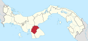  | |||

Content
Geography
The area of the province is 2340.7 km². Located in the south of the central part of the country. Borders on the provinces: Veraguas (in the west), Los Santos (in the southeast) and Kokle (in the north). In the northeast it is washed by the waters of the Gulf of Panama .
Population
The population of the province according to 2010 is 109 955 people. The population density is 46.97 people / km².
Administrative Division
Administrative division of the province of Herrera.
Administratively, the province is divided into 7 districts:
- Chitre
- Las minas
- Los posos
- Oku
- Paritas
- Pese
- Santa maria
Economics
The provincial economy is based on fisheries; production of sugarcane, dairy products, alcohol products, ceramics, cement; equipment repair.