

Below - the channel of the Peter and Paul
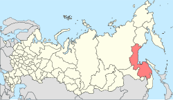
Khabarovsk Territory is located in the eastern part of the Russian Federation , in the Far Eastern Federal District . In the north it borders with the Magadan Region and the Republic of Sakha ( Yakutia ), in the west with the Jewish Autonomous Region , the Amur Region , and China , in the south with the Primorsky Territory , from the north-east and east it is washed by the Sea of Okhotsk , from the southeast - by the Sea of Japan . It is separated from Sakhalin Island by the Tatar and Nevelsky Straits . In addition to the main, continental part, several islands are part of the region, among them the largest are Shantarsky . The total length of the coastline is about 2500 km, including the islands - 3390 km.
The main mountain ranges are Sikhote-Alin , Suntar-Hayata , Dzhugdzhur , Bureinsky , Dusse-Alin , Yam-Alin . The highest point is Mount Beryl (2933 m), the lowest is sea level.
The territory of the region extends from south to north for 1800 km, from west to east - for 125-750 km. The total area of the region is 788,600 km², which is 4.5% of the entire territory of the country.
Climate
Climatic conditions change when moving from north to south, they also depend on proximity to the sea and on the shape and nature of the relief .
Winter in the region is long, not snowy, severe. The average January temperature is from −22 ° C in the south and to −40 ° C in the north, on the coast from −18 ° C to −24 ° C. The absolute minimum temperature even in the south of the region reaches −50 ° C. Summer is hot and humid. The average July temperature in the south is +20 ° C, in the north about +15 ° C.
The annual precipitation ranges from 400-600 mm in the north and up to 600-800 mm on the plains and eastern slopes of the ranges. In the south of the region up to 90% of precipitation falls from April to October , especially in July and August .
In the Khabarovsk Territory, two regions: Ayano-May and Okhotsk (as well as the Shantar Islands ) - are regions of the Far North .
Territories equivalent to regions of the Far North: Vaninsky , Verkhnebureinsky , Komsomolsky , Nikolaev , named after Polina Osipenko , Sovetsko-Gavansky , Solnechny , Tuguro-Chumikansky and Ulchi districts ; cities: Amursk , Komsomolsk-on-Amur , Nikolaevsk-on-Amur and Sovetskaya Gavan ; urban-type village of Elban, Amur region ; the villages of Achan , Juen , Voznesenskoye , Ommi , Padali of the Amur region .
Population
| Population | |
|---|---|
| Year | Population |
| 1926 | 147,000 |
| 1939 | 549,000 |
| 1950 | 608,000 |
| 1959 | 979,000 |
| 1970 | 1,174,000 |
| 1979 | 1,376,000 |
| 1989 | 1,609,000 |
| 1992 | 1,634,000 |
| 1996 | 1,571,000 |
| 2000 | 1,517,400 |
| 2002 | 1 436 570 |
| 2005 | 1 420 200 |
| 2007 | 1,405,452 |
| 2009 | 1,401,915 |
| 2010 | 1,344,200 |
According to the 2002 census, the region’s population was 1,466,570 people, of which 694,210 were men and 742,360 were women (48.3% and 51.7%, respectively). Compared to most regions of Russia, the Khabarovsk Territory is more urbanized , in 2002 the share of the urban population was 80.4%, of the rural - 19.6%. Khabarovsk is the largest city in the region, with a population of 583,072 people ( 2002 ). The second largest is Komsomolsk-on-Amur , with a population of 281,035 people. Of the remaining 5 cities of the region, 4 are small and 1 is medium.
There are seven cities, 24 urban-type villages and 426 rural settlements in the region.
The average population density in the region is about 1.8 people / km², in the northern and central regions of the region it does not exceed 0.1-0.2 people / km², which corresponds to the indicators of the far north. Only the more southern, developed areas are densely populated - from 1 to 6 people / km².
Administrative division
Khabarovsk Territory includes 2 urban districts and 17 municipal districts , on the territory of which there are 29 urban settlements and 188 rural settlements .
Urban counties
- City Khabarovsk
- City Komsomolsk-on-Amur
Forest Resources
The total area covered by forest in the Khabarovsk Territory is 52 million hectares, coniferous forests prevail, which occupy up to 85% of the forested area. The main species are larch and spruce.
Links
- Geography of the Khabarovsk Territory on allrf.ru