Akdarya (in the upper reaches of Aksu ) is a river in the Kashkadarya region of Uzbekistan .
| Akdarya | |
|---|---|
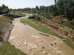 Akdarya on the southern outskirts of Kitab Akdarya on the southern outskirts of Kitab | |
| Characteristic | |
| Length | 154 km |
| Pool | 1280 km² |
| Water flow | 12.3 m³ / s |
| Watercourse | |
| Source | |
| • Coordinates | |
| Mouth | Kashkadarya |
| • Coordinates | |
| Location | |
| Water system | Kashkadarya |
| A country |
|
| Region | Kashkadarya region |

The length of the river is 154 km, the basin area is 1280 km². Akdarya originates on the slopes of the Gissar Range and flows into the Kashkadarya River. Food snow - glacial . The high water falls on the period from March to September with the maximum costs from May to June . Average water consumption is 12.3 m³ / s (at the Khazarnov kishlak ). Below the stock is disassembled for irrigation. The average consumption of suspended sediment is 12 kg / s. In the lower reaches of the river dries up, the course overgrown. Hydrocarbonate-calcium water, average salinity - 200-240 mg / l. On the bank of Akdarya is the city of Kitab .
Sources
- Akdarya // Dictionary of modern geographical names / Rus. geogr. oh Mosk. Centre; Under total ed. Acad. V.M. Kotlyakov . Institute of Geography RAS . - Yekaterinburg: U-Factory, 2006.