Schouten or Schouten ( Eng. Schouten Island [1] , on the old maps also used the name Schouten's Isle [2] ) - an island off the east coast of the island of Tasmania ( Australia ), is part of the state of Tasmania . The area of the island is 28 km² [3] .
| Joker | |
|---|---|
| English Schouten island | |
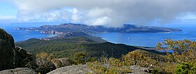 View of the island of Jouten from the top of Mount Freysine | |
| Characteristics | |
| Area | 28 km² |
| Highest point | 420 m |
| Population | 0 pax (2009) |
| Location | |
| Water area | Tasman Sea |
| A country |
|
| Region | Tasmania |


Content
- 1 Geography and geology
- 2 History
- 3 See also
- 4 notes
Geography and geology
Schouten Island is located south of the Freycinet Peninsula Peninsula , with which it forms the Freycinet National Park [4] . Schouten Island is separated from the Freysine Peninsula by a 1.6 km wide strait ( Schouten Passage ) [5] .
In the east, the island of Chouten is washed by the waters of the Tasman Sea , and in the west and northwest is Great Oyster Bay .
The highest point of the island of Shuten is Mount Story ( Mount Story [6] or Mount Storey [5] , 420 m high [6] ). A little east of it is the second highest mountain of the island - Dedalus ( Mount Daedalus , 400 m high [7] ).
A geological fault extending from north to south divides the island into an eastern part composed of granite and a western part composed of dolerite lying on sedimentary rocks [8] [9] .
The name sometimes used is the “ Schouten Island Group ”, which, in addition to the Schouten island, includes the Nuggets, Diamond Island , Governor Island , Picnic Island , Tyler Rocks ( Taillefer Rocks ), Ile des Phoques , Refuge Island and Little Christmas Island [10] .
History
In 1642, the Dutch navigator Abel Tasman sailed along the east coast of Van Diemen Land (the so-called Tasmania). He named the island after Jost Schouten ( Dutch Joost Schouten ), one of the leaders of the Dutch East India Company [10] .
Schoutin Island and the Freysine Peninsula were explored in more detail in 1802–1803 by the expedition of the French navigator Nicholas Baudin [11] , which, in particular, gave names to several capes of the island.
In 1809, a seal hunter, Joseph Stacey , had to land on an island, who discovered that there was coal on the island. Commercial development of coal deposits on the island began only in the 1840s by the Garland brothers - however, it turned out to be economically disadvantageous and soon ceased [11] .
In 1848, the Australasian Smelting Company took over the development of the coal field, which employed more than 60 prisoners, under the leadership of manager Edward Crockett. By 1850, 120-130 tons of coal were produced per week [11] . After that, Crockett directed coal mining for several years. In the 1880s, an entrepreneur Diego Bernacchi [12] attempted to restore coal mining, but without much success. In the same 1880s, Chinese miners mined tin on the island [11] .
See also
- Tasmania
- Peninsula of Freysine
- Great Oyster Bay
Notes
- ↑ Place Names Search: Schouten Island (link not available) . Australian Government - Geoscience Australia, www.ga.gov.au. Date of treatment November 27, 2011. Archived June 5, 2011.
- ↑ Chart of Van Dieman's Land, 1826 . National Library of Australia, www.nla.gov.au. Date of treatment November 27, 2011. Archived on September 4, 2012.
- ↑ Tasmania, Area of Major Islands (unavailable link) . Australian Bureau of Statistics, www.abs.gov.au. Date of treatment November 27, 2011. Archived on April 20, 2012.
- ↑ Freycinet National Park (unavailable link) . Tasmanian Parks & Wildlife Service, www.parks.tas.gov.au. Date of treatment November 27, 2011. Archived January 2, 2012.
- ↑ 1 2 Topographic map of Tasmania - Schouten Island (Link not available) . topomapper.com. Date of treatment November 27, 2011. Archived March 4, 2016.
- ↑ 1 2 LISTmap (Mount Story) (inaccessible link) . Tasmanian Government Department of Primary Industries and Water. Date of treatment November 27, 2011. Archived on September 4, 2012.
- ↑ LISTmap (Mount Daedalus) (inaccessible link) . Tasmanian Government Department of Primary Industries and Water. Date of treatment November 27, 2011. Archived on September 4, 2012.
- ↑ TD Hughes. Schouten Island (inaccessible link) . Mineral Resources Tasmania - Tasmanian Department of Infrastructure, Energy and Resources, www.mrt.tas.gov.au (1959). Date of treatment December 5, 2011. Archived on October 3, 2011.
- ↑ CA Bacon and KD Corbett. The Schouten Island Coalfield (link unavailable) . Mineral Resources Tasmania - Tasmanian Department of Infrastructure, Energy and Resources, www.mrt.tas.gov.au (1984). Date of treatment December 5, 2011. Archived on October 3, 2011.
- ↑ 1 2 East Coast Islands (link not available) . www.discovertasmania.com. Date of treatment December 5, 2011. Archived February 1, 2013.
- ↑ 1 2 3 4 Coles Bay and the Freycinet Peninsula, Tasmania (Unavailable link) . www.wineglassbay.com. Date of treatment November 27, 2011. Archived December 12, 2011.
- ↑ Wendy Rimon. Diego Bernacchi (Link unavailable) . Center for Tasmanian Historical Studies, University of Tasmania. Date of treatment December 6, 2011. Archived March 2, 2012.