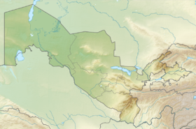
Nuratau , Nurata ridge ( Uzbek. Nurota tog'lari, Nurota tolari ) - a mountain range in Uzbekistan , one of the western spurs of the Gissar-Alai system . From the south it borders the Kyzyl Kum desert . In the east, it is separated from the ridge Malguzar by the deep gorge of the Tamerlane Gate .
| Nuratau | |
|---|---|
| Uzbek Nurota tog'lari | |
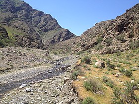 Northern Nurata Range, Sapsai River Valley | |
| Specifications | |
| Length | 170 km |
| Highest point | |
| Highest peak | Hayatbashi |
| Absolute height | 2169.5 m |
| Location | |
| A country |
|
| Mountain system | Gissaro Alai |
The length of the ridge is 170 km. The highest point is Mount Hayatbashi (2169.5 m). The ridge is composed mainly of sandstones , limestones and volcanic rocks . The crest is flat; the northern slope is steep, rocky, and the southern slope is flat, divided by valleys of small rivers . On the crest there are mountain steppes , on the slopes there is a shrub- steppe landscape . In the valleys of the southern slope - oases with gardens, kitchen gardens , irrigated fields.
Sources
- Nuratau - article from the Great Soviet Encyclopedia . .
- Dictionary of modern geographical names / Rus. geo about . Mosk. Centre; Under the total. ed. Acad. V.M. Kotlyakova . Institute of Geography RAS . - Yekaterinburg: U-Factoria, 2006 ..