Kawar ( fr. Kaouar ) is an oasis [1] 150 km in the north-east of Niger . It is a steep area. The highest point in the terrain (576 m) is Zumri Peak. Kavar is surrounded by the Tener desert . Located in the south of the Bilma department of the Agadez region.
| Kawar | |
|---|---|
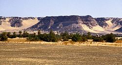 Kavar near Bilma | |
| A country | Niger |
| Desert | Tenere |

There are ten oases in Kavar , the largest of which are Bilme , Dirku , Aney and Szegedin , and there are settlements [2] . Due to the presence of water sources, the oases of Kavar have always been an important stop on the route through the Sahara , both in antiquity and now. In the Middle Ages, they were the main place for the production of dates and salt , for this reason the area was under the scrutiny of nomads , Tuaregs and the kingdom of Kanem-Borno .
There are several lakes: Ayama , Elki-Gernama , Barara and Kalala [1] .
The majority of the population of Kavar is Tuba . Tuba is chosen by the Sultan of Kavar - his traditional ruler, whose residence is in Aney [2] .
Notes
- ↑ 1 2 Map sheet E-33-VII .
- ↑ 1 2 Historical Dictionary of the Niger, 1997 , p. 179.
Literature
- Nizskaya L.O. Republic of Niger. Directory. - M .: Nauka, 1989 .-- 227 p. - 3950 copies. - ISBN 5-02-016972-2 .
- Decalo, Samuel. Historical Dictionary of the Niger (3rd ed.). - Boston & Folkestone: Scarecrow Press, 1997 .-- 486 p. - ISBN 978-0810831360 .