Thar [2] ( Hindi थार मरुस्थल , Thar [3] ) is a desert in northwestern India and southeast Pakistan . Area - about 446 thousand square meters. km: the desert stretches for 850 km in length and 485 km in width. Most of the desert territory is in the Indian state of Rajasthan ( Bikaner , Churu , Ganganagar and Hanumangarhar districts ), the desert also covers the southern states of Haryana and Punjab and the north of Gujarat . In Pakistan, the desert extends to the eastern part of Sindh province and the southeastern part of Pakistani Punjab , where it is called the Kholistan desert [4] . A continuation of the Thar Desert is the Thal Desert , located in the Pakistani province of Punjab .
| Tar | |
|---|---|
| Raj. थार मरुधर , Hindi थार मरुस्थल | |
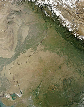 Thar Desert, NASA satellite imagery with Indo-Pakistan border line drawn | |
| Specifications | |
| Type of | sandy |
| Absolute height | 200 m |
| Length | 850 [1] km |
| Width | 485 [1] km |
| Square | 446,000 [1] km² |
| Water resources | |
| Rivers | Ghaggar , Looney |
| Channels | Rajasthan |
| Location | |
| Country |
|

The climate is tropical; precipitation from 90 mm per year in the west to 200 mm in the east (rain during the summer monsoon ). Dust storms are frequent . In the depressions between the ridges are small lakes, salt marshes and takyrs . Groundwater is plentiful, salted in some places. Thinned vegetation - psammophilic shrubs (leptadenium, kapparis, juzgun); Acacia, hard grass are found. Pastoral livestock. In the oases and along the Indus valley, irrigated agriculture.
Content
Relief and boundary description
In India, the borders of the Thar desert are: in the northwest, the Sutlej River; in the northeast - the Aravalli Range , in the south - the salt marshes of the Great Kach Rann (which are sometimes included in the Thar desert), in the west - the Indus River . The northern border - with thorny steppe steppes - is poorly expressed. In Pakistan, the main desert region is Tarparkar, which actually means "the other side of the Thar desert." In the west, Parkar is an irrigated territory, while in the east it is an absolutely waterless desert. Precipitation here falls 100-500 mm per year, mainly from July to September [1] .
The Tar desert is a type of sandy desert with a subtropical belt in the north and a tropical one in the south. In general, the territory is flat, lowering to the Indus Valley and the Kachsky Rann salt flats, with a height difference from east to west of 175 m (average height of 100–200 m, at the foot of Arawalli 350–450 m). Geologically and geomorphologically, the Thar Desert is associated with the ancient Indus Valley, which is confined to the region of the vast foothill trough between the western edge of the Deccan Plateau (Aravalli Range) and the eastern edge of the Iranian Highlands (Mekran and Suleyman Mountains ) [1] .
The desert is composed of sand of alluvial, marine or aeolian origin, overlapping ancient sandstones, which in some places come to the surface. Dunes of Tar are divided into three types - longitudinally parabolic, transverse and dunes. The first type is characteristic of the southern and western parts of the Thar desert. The transverse dunes aligned with the direction of the wind are in the east and south of Tar, and the dunes are mainly located in the central part of Tar. Dunes in the south of the desert are higher, sometimes rising to 152 m, while in the north they are lower and rise 16 m above the ground [5] .
In the Thar desert, two main bands of dunes running along the Indo-Pakistani border can be distinguished. The first (50 to 100 km wide) runs south of the Indian town of Anupgarh , and most of its surface is covered with high sand dunes (10–15 m), elongated from north-east to south-west in the form of longitudinal sand ridges. The second strip (from 75 to 125 km wide) is covered with low sand dunes or sand fields. It extends between the Aravalli range and the conditional line connecting the cities of Ranivara , Balotra , Nagaur and Sikar . Between these two belts of low dunes in the east and high in the west lies the territory, which represents numerous low plateaus dotted with pebbles. These plateaus are also divided among themselves by dunes [1] .
Climate
The climate of the Thar desert is dry, subtropical continental. Heat resources are significant. The total annual solar radiation ranges from 200 to 220 kcal / sq. cm, which is equal to the total annual solar radiation of the hottest parts of the Sahara and the Mojave Desert . In summer, the average daily maximum temperature, as a rule, is 40 ° C, in winter +22 ... 28 ° C. The average minimum temperature varies from 24 ° C in summer to 4 ° C in winter [1] .
With complete cloudlessness at night, strong daily temperature fluctuations occur. In summer, these fluctuations are about 14.5 °, in winter - 18.5 °. The annual amplitude of fluctuations in average monthly temperatures reaches 22.9 ° in Ganganagar , 20.3 ° in Bikaner . The absolute maximum in Ganganagar is + 50 °. The average relative humidity is 36–50% in the summer and 66–78% during the monsoon in the morning. Evaporation is high, amounting to over 3 thousand mm per year. The average annual rainfall varies from 105 in the west to 500 mm in the east. The distribution of precipitation is uneven: most of it falls between July and September. Rainfall falls to the west. In the driest areas, precipitation may be absent for up to 2 years. In May-June, dust storms are frequent, bringing rainfall and sharply lowering the temperature. Their number and intensity decrease to the east. The largest number of dust storms is dated to June in the northwest and to May in the south and southeast. In Ganganagar, sandstorms occur on average 27 days per year, and in Bikaner - 18 days [1] .
Hydrography
As a result of an unstable amount of precipitation, surface water sources are practically absent. Groundwater, which is also insufficient, lies too deep from the surface (30-120 m) [5] . Most of these waters are unsuitable for water supply. In lowered areas, salt lakes and salt marshes can be found. Working artesian wells exist only in some areas.
About 24% of the territory receives drinking water and irrigation water from the Rajstkhan Canal. Indira Gandhi. Water scarcity is the main threat to agricultural production. In Rajasthan, the only river crossing the sands, the Luni , begins in the Pushkar Valley from the spurs of the Aravalli Range, and ends in the salt marshes of the Great Kachsky Rann in Gujarat . Another river with a variable flow in India - Ghaggar - is full-flowing only after monsoon rains. She crosses the states of Punjab and Haryana and feeds two irrigation canals extending to Rajasthan [1] .
Desert Origin
The origin of the Thar Desert is still debated. Some scientists believe that the age of the desert is up to 1 million years, although some argue that aridity appeared in the region much earlier [1] .
According to another version, these territories have become a desert quite recently - 5–2 thousand years BC. e., when Ghaggar ceased to be the main river. Now this river ends in the desert of Cholistan , but once it flowed into the Arabian Sea and was called Saraswati . It was the central watercourse for Mohenjo-Daro , the center of the Indian Valley civilization. Satellite sensing data suggest that neotectonic movements and climatic changes at the end of the Quaternary played a significant role in the transformation of the channels of watercourses in this region [1] .
According to the third hypothesis, the Thar desert is mainly of anthropogenic origin [1] .
Attractions
- The Golden Fortress Jaisalmer
- Nawab Citadel Daravar
- The princely palaces of Bikaner
- Desert National Park
Notes
- ↑ 1 2 3 4 5 6 7 8 9 10 11 12 Plant world of the Thar and Thal deserts
- ↑ Tar // Dictionary of geographical names of foreign countries / ed. ed. A.M. Komkov . - 3rd ed., Revised. and add. - M .: Nedra , 1986. - S. 359.
- ↑ Instructions for the transfer on maps of geographical names from Hindi. - M .: TsNIIGAiK, 1959. - S. 24.
- ↑ Lev Y. Borkin. Three expeditions of the St. Petersburg Union of Scientists in India: the western Himalayas (2011 and 2013), the Thar desert and the Arabian coast (2014) // Historical and biological research: journal. - 2014. - T. 6 , No. 4 . - S. 124-133 . - ISSN 2076-8176 .
- ↑ 1 2 Dunes