Joy is a village located on the island of Kunashir , 4 km from South Kurilsk on the Pacific Ocean . According to the administrative-territorial division of Russia , the village is part of the South Kuril urban district of the Sakhalin region of Russia [5] .
| Village | |
| Joy | |
|---|---|
 | |
| A country | Russia [1] |
| Subject of the federation | Sakhalin Oblast |
| City district | South Kuril |
| History and Geography | |
| Former names | until 1946 - Tikappunay |
| Timezone | and |
| Population | |
| Population | ↘ 142 [2] people ( 2010 ) |
| Nationalities | Russians [3] |
| Digital identifiers | |
| Postcode | 694500 |
| OKATO Code | 64256551002 |

Kekur "The Devil's Finger", which is located near the village of Joy

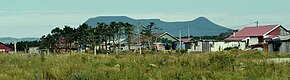
The road to the village of Joy, in the background - the village of Yuzhno-Kurilsk
History
Until 1945, the village belonged to the Japanese governorate of Karafuto and was called Matakotan . After the transfer of South Sakhalin to the USSR, the village received its modern name (the Free option was also proposed) [6] .
Population
| Population | |
|---|---|
| 2002 [7] | 2010 [2] |
| 169 | ↘ 142 |
According to the 2002 census, the population is 169 people (104 men, 65 women). The predominant nationality is Russian (77%) [3] .
Notes
- ↑ This village is located on the island of Kunashir . Kunashir is the subject of a territorial dispute between Russia , the ruling island, and Japan . In accordance with the Constitution of the Russian Federation, the island is part of the territory of the Russian Federation , according to the administrative-territorial division of Japan - it is part of the Nemuro District of Hokkaido Prefecture in Japan .
- ↑ 1 2 2010 All-Russian Population Census. Sakhalin region. The population of urban districts, municipalities, urban and rural settlements, urban settlements, rural settlements . Date of treatment July 28, 2014. Archived July 28, 2014.
- ↑ 1 2 2002 Census data: Table 2C. M .: Federal State Statistics Service, 2004.
- ↑ 1 2 Federal Law dated 09.03.2016 No. 59-ФЗ - 2016.
- ↑ Law of the Sakhalin Region dated July 21, 2004 No. 524 “On the Borders and Status of Municipalities in the Sakhalin Region”
- ↑ I. A. Samarin . About the history of renaming of settlements in South Sakhalin and the Kuril Islands in 1946-1947, p. 222
- ↑ 2002 All-Russian Census Data: Table No. 02c. Population and prevailing nationality for each rural locality. M .: Federal State Statistics Service, 2004