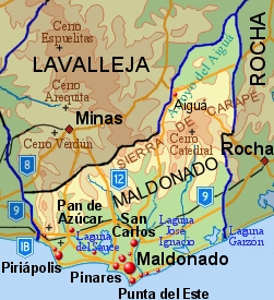
Maldonado ( Spanish: Maldonado ) is a department in southern Uruguay . The area is 4,793 km² (2.71% of the total area of the country). The administrative center is the city of the same name, located 140 km from the capital, Montevideo .
| The Department | |||||
| Maldonado | |||||
|---|---|---|---|---|---|
| Spanish Maldonado | |||||
| |||||
| A country | Uruguay | ||||
| Includes | 8 municipalities | ||||
| Adm. Centre | Maldonado | ||||
| History and Geography | |||||
| Date of formation | |||||
| Square | 4,793 km² (17th place ) | ||||
| Height | |||||
| Timezone | UTC-3 | ||||
| Population | |||||
| Population | 164 300 people ( 2011 ) ( 3rd place ) | ||||
| Density | 34.28 people / km² (3rd place) | ||||
| Digital identifiers | |||||
| ISO 3166-2 Code | UY-MA | ||||
| Telephone code | |||||
| Official site | |||||
 | |||||
 | |||||

![Coat of arms [d]](http://upload.wikimedia.org/wikipedia/commons/thumb/1/14/Coat_of_arms_of_Maldonado_Department.png/90px-Coat_of_arms_of_Maldonado_Department.png)
Content
Geography and climate
The north of the department is mountainous, the highest point of the country is here - Mount Cerro-Catedral (514 m). The central regions are hilly, with an average height of about 150 m above sea level. The south is occupied by the coastal plain of the Atlantic Ocean and several ridges of hills. The climate is subtropical, humid, with an average temperature of 17 ° C and an average annual rainfall of about 1000 mm. The most fertile soils are located in the western part of the department.
Population
The population according to the 2004 census is 140 192 people [1] . The population density is 29.25 people / km². Fertility - 17.1 per 1000 people. Mortality is 7.06 per 1000 people. The average age of the population is 31 years (30.1 for men and 32 for women). The average life expectancy is 76.2 years (72.19 for men and 80.37 for women).
Big cities:
| City | Population [2] , people (2011) |
|---|---|
| Maldonado | 62 590 |
| San carlos | 27 471 |
| Pinares - Las Delicias | 9819 |
| Punta del este | 9277 |
| Piriapolis | 8830 |
| Cerro Pelado | 8177 |
| Pan de Asucar | 6597 |
| San Rafael - El Placer | 3146 |
| La capuera | 2838 |
| Aigua | 2465 |
| Barrio Hippodromo | 1973 |
Administrative Division
The Maldonado Department is divided into 8 municipalities:
| No. | Municipality | Population [3] , people (2011) | Square, km² |
|---|---|---|---|
| one | Aiguá | 4,500 | 1,246 |
| 2 | Garzón | 900 | 719 |
| 3 | Maldonado ( Maldonado ) | 105 000 | 192 |
| four | Pan de Azúcar | 9 500 | 719 |
| five | Piriápolis | 14,000 | 192 |
| 6 | Punta del Este | 15 000 | 48 |
| 7 | San Carlos | 27 000 | 1 438 |
| eight | Solis Grande | 4 600 | 240 |
Notes
- ↑ http://www.ine.gub.uy/fase1new/Maldonado/Cuadro7_10.XLS
- ↑ Censos 2011 Cuadros Maldonado . INE (2012). Date of treatment August 25, 2012. Archived November 22, 2012.
- ↑ Presupuesto 2011 - 2015 de la Intendencia Departamental de Maldonado (IDM) (unavailable link) . Date of treatment April 2, 2013. Archived April 6, 2013.