Shimane [1] ( 島 根 県 Shimane-ken ) is a prefecture located in the Chugoku region on Honshu Island, Japan . The prefecture has an area of 6,707.96 km² [2] , a population of 697,398 people (August 1, 2014) [3] , and a population density of 103.97 people / km². The administrative center of the prefecture is the city of Matsue .
| Shimane Prefecture 島 根 県  Izumo Taisha Izumo Taisha | |
|---|---|
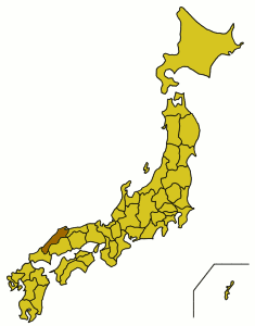 Shimane Prefecture on a map of Japan  Map of Shimane Prefecture | |
| Location | |
| A country | Japan |
| Region | Chugoku |
| Isle | Honshu |
| Coordinates | |
| Information | |
| Administrative center | Matsue |
| ISO 3166-2: JP | Jp-32 |
| Statistics | |
| Square | 6707.96 km² ( 18th ) |
| % water | 2.7% |
| Population | (as of August 1, 2014) |
| Total | 697,398 people ( 46th ) |
| Density | 103.97 people / km² |
| Counties | five |
| Municipalities | nineteen |
| Symbolism | |
 Prefecture flag | |
 Emblem of the prefecture | |
| Tree | Thunberg Pine ( Pinus thunbergii ) |
| Flower | Tree Peony ( Paeonia suffruticosa ) |
| Bird | Whooper Swan ( Cygnus cygnus ) |
| A fish | Flying Fish ( Exocoetidae ) |
| Administration | |
| Governor | Zembe mizoguchi |
Content
Administrative division
In Simane Prefecture, there are 8 cities and 5 counties (10 villages and one village).
Cities
List of cities in the prefecture:
|
|
Counties
Towns and villages in counties:
|
|
|
|
|
Symbols
The emblem and flag of the prefecture were introduced on November 8, 1968. In addition, another logo was created in 1990 [4] .
In 1953, the tree-shaped peony was chosen as the flower of the prefecture, the tree was Tunberg pine (1966), the whooper swan (2000), and the flying fish (1989) [4] .
Notes
- ↑ Geographic Encyclopedic Dictionary: Geographic Names / Ed. A.F. Treshnikov . - 2nd ed., Ext. - M .: Soviet Encyclopedia , 1989. - S. 435. - 210 000 copies. - ISBN 5-85270-057-6 .
- ↑ The area is indicated according to the Geospatial Information Authority of Japan (Japanese) , subject to changes published on October 1, 2011.
- ↑ 平 成 26 年 (2014) (Japanese) . Shimane Prefecture Administration (August 1, 2014). - The population of Shimane Prefecture. Date of treatment September 3, 2014.
- ↑ 1 2 全国 知事 会 ホ ー ム ペ ー ジ (Japanese) (inaccessible link) . National Governors' Association. Date of treatment June 15, 2010. Archived on April 7, 2008.
Links
- Simane Prefecture Business Development Center (official Facebook page) https://www.facebook.com/shimane.center/
- Wikimedia Commons has media related to Siman
- Official site
- Simane Prefecture Business Development Center
- SIMANE // Japan from A to Z. Popular Illustrated Encyclopedia. (CD-ROM). - M .: Directmedia Publishing , "Japan Today", 2008. - ISBN 978-5-94865-190-3 .
- Simane - an article from the Great Soviet Encyclopedia .
Invalid parameter