Chiba ( 千葉 県 иб Chiba-ken ) is a prefecture located in the Kanto region of Honshu Island, Japan . The prefecture's area is 5156.61 km² [1] , the population is 6 196 701 people (August 1, 2014) [2] , the population density is 1201.70 people / km². The administrative center of the prefecture is the city of Chiba .
| Chiba Prefecture 千葉 県  Clockwise from above: Makuhari new city, Keio Industrial Area, Makuhari Messe, Narita Airport Terminal 1, Chiba Port, Shinsho Temple Clockwise from above: Makuhari new city, Keio Industrial Area, Makuhari Messe, Narita Airport Terminal 1, Chiba Port, Shinsho Temple | |
|---|---|
 Chiba Prefecture on a map of Japan 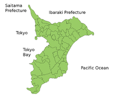 Map of Chiba Prefecture | |
| Location | |
| A country | Japan |
| Region | Kanto |
| Isle | Honshu |
| Coordinates | |
| Information | |
| Administrative center | Chiba |
| ISO 3166-2: JP | Jp-12 |
| Statistics | |
| Area | 5156.61 km² ( 28th ) |
| % water | 0.8%% |
| Population | (as of August 1, 2014) |
| Total | 6 196 701 people ( 6th ) |
| Density | 1201.70 people / km² |
| Counties | 6 |
| Municipalities | 54 |
| Symbolism | |
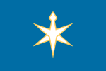 Prefecture flag | |
 Emblem of the prefecture | |
| Wood | Large-leaved legume ( Podocarpus macrophyllus ) |
| Flower | Turnip ( Brassica rapa var. Amplexicaulis ) |
| Bird | Rubella Oatmeal ( Emberiza cioides ) |
| Administration | |
| Governor | Kensaku Morita |
Content
- 1 History
- 2 Geography
- 3 Administrative division
- 3.1 Cities
- 3.2 Counties
- 4 Economics
- 5 Transport
- 6 Demographics
- 7 Education
- 8 Tourism
- 9 Symbols
- 10 notes
- 11 Links
History
It was founded on June 15, 1837 as a result of the unification of the prefectures of Kisarazu and Imba [3] . Before the introduction of the Todofuken system, the prefecture consisted of three provinces - Ava , Kazusa and Shimos .
Geography
Chiba borders Ibaraki north of the Ton River, with Tokyo and Saitama in the west, washed by the Pacific Ocean in the east and Tokyo Bay in the south. The predominant part of Chiba lies on the hilly Boso Peninsula, a rice-growing area: the east coast, known as the 99 league plain, is a particularly productive region. The most populated area is the northeast of the prefecture - part of the Kanto region, which extends into the metropolitan area of Tokyo and Saitama. The Kuroshio Current flows near Chiba, which makes the winter relatively warm and the summer cool compared to neighboring Tokyo.
Administrative division
In Chiba prefecture, there are 37 cities and 6 counties (16 villages and one village).
Cities
List of cities in the prefecture:
|
|
|
|
The largest cities in the prefecture: Chiba (960 thousand), Funabashi (610 thousand), Matsudo (485 thousand), Ichikawa (475 thousand) and Kashiva (400 thousand).
Counties
Towns and villages in counties:
|
|
Economics
Chiba, due to its long coast and proximity to Tokyo, is one of the largest industrial zones in the country. After the prefecture was chosen in 1950 for the construction of the Kawasaki main steel mill, local authorities began a large-scale program to reclaim large tracts of land for factories, warehouses and docks. Chemical production, petrochemicals and mechanical engineering are the three main industrial sectors of Chiba: together they account for 45% of the prefecture's exports. Also of great importance in the economy of Chiba are trade, transport, metallurgy, food industry and tourism. In the 80-90s, the government founded more than 80 industrial zones designed to accelerate the development of the inner regions of Chiba.
The prefecture is also famous for the second largest agricultural production in Japan: among all the prefectures, only Hokkaido produces more, but Chiba is ahead of Hokkaido in growing vegetables. Seaweed is collected in large numbers.
In the city of Chiba, the corporations Aeon (retail and financial services), Chiba Bank (finance), Seiko Instruments (electronics), Chiba Urban Monorail (rail transportation), and Chiba Tv (television) are based ), BMW Dzhapan (distribution of cars) and Er-I Amenia (tuning cars and production of components). Mabsuto Motor corporations (electric motors), Seiko Giken (optical and electronic equipment) and Matsumoto Kiyoshi corporations (retail) are based in Matsudo , Oriental Land Company (entertainment, tourism, hotels and trade) in Urayasu . in Ichikawa - “Kawasaki Kisen Kaisya” (shipping), in Mobara - Futaba Corporation (toys and radio-controlled models), in Yatiyo - “Pearl” (musical instruments), in Noda - “ Kikkoman ” (sauces, drinks, pharmaceuticals and restaurants) in Funabashi - "Fuji foods" (food), in Tosi - "JICA" (sauces), in CAMAG - "Syn- Electric aysey Reylvey "(rail).
Among the largest employers in the prefecture, the Kawasaki Steel Metallurgical Plant (JF-Steel Steel Corp.), Tokyo Electric Power Thermal Power Station, the port of Chiba with the Marubeni terminal, the Makukhari Messe exhibition complex, and the Chiba railway stations are distinguished. (East Japan Railway Company) and Kisei Chiba (Kaysai Electric Railway), World Business Garden office complex, IBM technology center, Makukhari Prince Hotel in Chiba , Narita International Airport, railway Narita Station (East Japan Railway Company) "Kaysey Narita" ( "Kaysey Electricians Reylvey"), Repair Plant "The Japan Turbine Technologies" ( "Pratt & Whitney" / "The Japan Airlines"), a pharmaceutical plant "Es Es Pharmaceutical" hotels "Hilton" and "Mercure" in Narita , Tokyo Disney Resort amusement park ( Disneyland and Disney Parks, Sheraton, Hilton, Okura, Tokyu, Mayhama, Dream Gate, Disney Ambassador, Tokyo Disney Sea and Tokyo Disneyland) in Urayasu , Nippon Steel Metallurgical Plant in Kimitsu , Sapporo Brewery Brewery in Funabashi , Thermoelectric Power Station Tokyo Electric Power, Cosmo Oil and Idemitsu Kosan refineries in Itihara , Tokyo Electric Power Thermal Power Station, Mitsui Sumitomo Insurance Group and CSC Holding Corps data centers, technology center Mabuchi Motor in Inzai , Tokyo Electric Power Thermal Power Station and Fuji Oil Oil Refinery in Sodegaura , Nikka Whiskey Distilling Distillery and Asahi Soft Drinks Soft Drink Factory in Kashiwa , Tokyo Electric Power Thermal Power Station in Futsu , alloy plant "Hita and Metals "in Matsudo , amusement park" Kamogawa SeaWorld "and hotel" Kamogawa Grand "in Kamogawa .
In the prefecture, there are large shopping centers and department stores: Aeon Marche (with the Carrefour hypermarket), Mitsui Outlet Park and Sogo in Chiba , LaLaPort (Mitsui), Ikea and Seibu in Funabashi , Aeon, LaLaPort and Mallage in Kashiwa , Ikspiari and Bon Voyage (Tokyo Disney Resort), Ito Yokado in Urayasu , Nikka Colton Plaza in Ichikawa , Aqua ”In Kisarazu ,“ Chiba New Town ”(“ Aeon ”) and“ Makinohara ”in Inzai ,“ Ito-Yokado ”in Narita ,“ Akao Mall ”in Kamagaya ,“ Isetan ”in Matsudo ,“ Aon ”in Nagareyama .
Transport
- Kokudo 16
Demographics
Chiba's population is one of the richest in Japan due to its strong commercial and industrial sectors. GDP per capita is 3.1 million yen, the fifth largest figure in the country. 70% of the population is involved in the services sector, 25% in industry and 5% in agriculture.
Education
The local education authority oversees municipal school districts; also directly directs public secondary schools.
Tourism
Disneyland Tokyo is located in Urayasu - near the western border of the prefecture.
Chiba is connected to Tokyo by several railway lines: the main lines are the Keio Line and the Sobu Line. The Musashino line connects Chiba with Saitama and northern Tokyo. The south of Chiba ( Kisarazu ) is connected to Kanagawa Prefecture by the Tokyo Bay Aqua Line tunnel bridge through the waters of Tokyo Bay .
Narita International Airport is located in Narita , which is located in the northeast of Chiba.
Symbols
The emblem of the prefecture was created on December 28, 1909. It is a combination of stylized symbols of the katakana "ty" ( Japanese チ ) and "ha" ( Japanese ハ ) . The flag of the prefecture was approved on July 29, 1963. The blue color of the flag symbolizes the hope and development of the prefecture, and yellow - the flower of turnip [3] .
Although the flower of the prefecture has not been officially approved, it is considered a turnip flower. It was chosen by residents of the prefecture in 1954 as a result of a survey conducted by NHK . Large-leafed throat was chosen as a tree of the prefecture (September 29, 1966), red-eared bunting (May 10, 1965), and red thai (February 23, 1989) as a bird [3] .
The day of the prefecture is considered June 15 [3] .
Notes
- ↑ The area is indicated according to the Geospatial Information Authority of Japan (Japanese) , subject to changes published on October 1, 2011.
- ↑ 市区 町 村 別人 口 と 世 帯 (最新) (Japanese) . Administration of Chiba Prefecture (August 29, 2014). - The population of Chiba Prefecture. Date of treatment August 31, 2014.
- ↑ 1 2 3 4 Symbols of Chiba Prefecture . Chiba Prefectural Government. Date of treatment June 15, 2010. Archived February 18, 2012.
Links
- Wikimedia Commons has media related to Chiba
- Official Website (Eng.) (Cor.) (Japanese)
- CHIBA // Japan from A to Z. A popular illustrated encyclopedia. (CD-ROM). - M .: Directmedia Publishing , "Japan Today", 2008. - ISBN 978-5-94865-190-3 .
- Chiba (prefecture in Japan) - article from the Great Soviet Encyclopedia .
- 千葉 県 (Japanese) . Geospatial Information Authority of Japan. - The geographical coordinates of the settlements of Chiba Prefecture. Date of treatment July 23, 2010.
- 千葉 県 内 市町村 (Japanese) . Local Authorities Systems Development Center. - Identification codes, names, postal addresses and phone numbers of the administrations of the settlements of Chiba Prefecture. Date of treatment July 23, 2010.