Pahacha [2] (Pogycha, Pokach, Pokhacha [3] ) - a river in Kamchatka . It flows through the territory of the Olyutor district of the Kamchatka Territory of Russia .
| Plowman | |
|---|---|
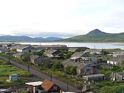 The village of Pahachi on the spit at the mouth of the river. In the middle plan - the estuary formed by the river The village of Pahachi on the spit at the mouth of the river. In the middle plan - the estuary formed by the river | |
| Characteristic | |
| Length | 293 km |
| Water consumption | 300 m³ / s (mouth) |
| Watercourse | |
| Source | |
| • Location | Koryak Highlands |
| • Height [?] | ≈ 1100 m |
| • Coordinates | |
| Mouth | Olyutor Bay |
| • Height | 0 m |
| • Coordinates | |
| Location | |
| Water system | Bering Sea |
| A country |
|
| Region | Kamchatka Krai |
| Area | Olyutor District |
| HWR code | |


The river is 293 km long [4] . The catchment area is 13,400 km² .
It takes its source within the Koryak Highlands in the spurs of the Ledyanaya Mountain. It falls into the Olyutor Bay . Near the mouth of the river is the village of Pahachi , in the middle reaches - the village of Middle Pahachi .
Content
Hydrology
The long-term average annual water discharge at the river mouth is 300 m³ / s (discharge volume 9.468 km³ / year, discharge modulus 25.6 l / (s × km²)). 70% of the annual runoff falls on the spring-summer flood, in winter only 3-5%. Mineralization of water during a maximum runoff of less than 50 mg / l. The average turbidity is 13.1 g / m³. Water belongs to the hydrocarbonate class and calcium group [5] .
The river’s nutrition is mixed, while the proportion of rainfall in some years reaches 30%. The peak of flood occurs in June-July, ends in early August. In the fall, rain floods are often observed, often in height exceeding the spring-summer flood. Freeze-up begins in late October - early November, lasting an average of 220-240 days. The largest ice thickness reaches 120 cm. Ice drift begins in late April - early May, during which ice jams often form, which lead to flooding of settlements [5] .
Historical Information
Cossack Ivan Erastov , considered to be the Russian discoverer of the river, reported it in 1646 [3] . From the beginning of the 18th century, the river begins to be applied to Russian maps and drawings. Russian interest in this area was associated with the "Pakhachin sable." As a result of active hunting, the number of animals decreased and Russian interest in this area fell, since the river was away from the path to the Anadyr prison [3] .
For a long time, the coastal region at the mouth of Pakhachi, like the entire Olyutor Bay, was mapped rather conventionally until in 1876 Mikhail Onatsevich on the Horseman clipper and in 1885 Fridolf Gek on the Sibir schooner conducted detailed studies [3] .
In the 1930s, two fish canneries and a fish base of the Kamchatka Joint Stock Company were built on a sandy spit at the mouth of the river (which had a different configuration then). Later they were transformed by the Pakhachinsky fish factory, later renamed the Olyutor fish factory [3] .
Hydronym
The name probably happened Koryakskogo Paӄychan - "the place of dried skins of the head (crown) of animals" [6] .
Ichthyofauna
Sockeye salmon, coho salmon, Arctic char, Kamchatka grayling, Siberian vendace, whitefish, thin-tailed burbot live in the river’s waters [5] .
Tributaries
Objects are listed in order from mouth to source.
- 1 km: untitled river
- 9 km: Chavanchan
- 24 km: untitled river
- 28 km: Wichignaivayam
- 35 km: Left Yakhinmuvayam
- 39 km: untitled river
- 45 km: Mainytayvaym
- 52 km: Lgunakanyau
- 56 km: Greater Emtetkonvayyam
- 68 km: Tekleveem the Third
- 76 km: Mainylvygorgyn
- 78 km: Vayuvayam
- 80 km: Neyuyuveem stream
- 81 km: untitled river
- 83 km: untitled river
- 90 km: Big Atalvayam
- 100 km: Pylgovyam
- 103 km: untitled river
- 108 km: untitled river
- 117 km: Ilpinayvayam
- 120 km: untitled river
- 121 km: untitled river
- 128 km: Kuchkutkin
- 135 km: Yachnolgiveem
- 147 km: Big Vochvivyam
- 155 km: Etetkin
- 169 km: untitled river
- 173 km: Hainkonkolav
- 175 km: Grand Hinkonkolav
- 176 km: Apavylgin
- 181 km: untitled river
- 182 km: untitled river
- 193 km: Echvayam
- 197 km: Kaginpenclave
- 200 km: untitled river
- 211 km: untitled river
- 222 km: Maly Tykelnyn
- 225 km: Bolshoy Tykelnyn
- 228 km: Helmivem
- 231 km: Pipikelnyn
- 232 km: Tykelnyn
- 233 km: Small Ayanki
- 244 km: Lesser Vallen
- 258 km: Grand Vallein
Water registry data
According to the state water register of Russia , it belongs to the Anadyro-Kolyma Basin District .
The code of the object in the state water registry is 19060000212120000004628 [4] .
Notes
- ↑ Surface Water Resources of the USSR: Hydrological Understanding. T. 20. Kamchatka / ed. V. Ch. Zdanovich. - L .: Gidrometeoizdat, 1966 .-- 260 p.
- ↑ Pakhacha ( No. 0303226 ) / Register of names of geographical objects on the territory of the Kamchatka Territory as of 11/30/2016 // State catalog of geographical names. rosreestr.ru.
- ↑ 1 2 3 4 5 Martynenko, 1991 , p. 87.
- ↑ 1 2 State Water Register . Pahacha . textual.ru . Ministry of Natural Resources of Russia (March 29, 2009). Date of treatment December 20, 2018. Archived March 29, 2009.
- ↑ 1 2 3 Pahacha . - An article from the popular science encyclopedia Water of Russia.
- ↑ Leontyev V.V. , Novikova K.A. Toponymic Dictionary of the North-East of the USSR / scientific. ed. G. A. Menovschikov ; FEB AN USSR . North-East complex. Research institutes. Lab archeology, history and ethnography. - Magadan: Magad. Prince Publishing House , 1989 .-- S. 302. - 456 p. - 15,000 copies. - ISBN 5-7581-0044-7 .
Literature
- Martynenko Valery. Kamchatka coast. Historical location . - Petropavlovsk-Kamchatsky: Far Eastern Book Publishing House, Kamchatka Branch, 1991. - 190 p.