Muldakkul (Muldak; bashk. Muldaҡ kүl ); the local name is Tozlokul ( Bashk. Toҙlokol - “salt lake”) - a salt-free drainage lake in the Abzelilovsky district of Bashkortostan. Nearby is the village of Ozernoye , Mount Muldak-tau . 15 km to the west - Magnitogorsk .
| Lake | |
| Muldakkul | |
|---|---|
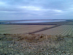 View of the lake from Muldaktau mountain | |
| Morphometry | |
| Absolute height | 406.9 m |
| Dimensions | 3.1 × 2.0 km |
| Square | 6.2 km² |
| Volume | 0,0131 [1] km³ |
| Deepest | 2.5 m |
| Average depth | 2.1 m |
| Pool | |
| Pool area | 49.6 km² |
| Location | |
| A country |
|
| The subject of the Russian Federation | Bashkortostan |
| Area | Abzelilovsky district |
| Identifiers | |
| HWR : | |
Content
Feature
The volume of water is 13.1 million m³. The surface area is 6.2 km². The catchment area is 49.6 km² [1] . Altitude - 406.9 m [3] .
Muldak is located on the watershed of rr. Yangelka and Small Dogwood .
Solo-loving rare plants grow on the gentle shores of the lake: salt moss , killer moth , water pepper, goose cinquefoil, European salt marsh, reed. Forest is rare due to the abundance of salt.
In some places along the banks and at the bottom there are large reserves of salted healing black mud used by the sanatoriums of Bashkortostan (the Yaktykul sanatorium was opened on the basis of these muds).
Karst lake, formed in Carboniferous rocks (limestones with interbeds of mudstones); the basin is round, elongated from north to south, symmetrical; muddy bottom.
Drainage-free, contains mineral mud (volume - 1 million tons). The food is mixed. The water is bitter-salty, magnesium chloride (12.6 g / l). The lake is mesotrophic. The banks are gentle, piled with sand.
Landscapes - fescue-feather grass steppes.
Water registry data
According to the geographic information system of water management zoning of the territory of the Russian Federation, prepared by the Federal Agency for Water Resources [4] :
- Water Code 12010000311112200000568
- Hydrological Code 212200056
- Pool code - 01.05.00.001
- GI Volume Number 12
- GI Issue 2
Notes
- ↑ 1 2 A.M. Gareev. Muldakkul // Bashkir Encyclopedia / ed. M.A. Ilgamov. - Ufa: GAUN “ Bashkir Encyclopedia ”, 2015—2019. - ISBN 978-5-88185-306-8 .
- ↑ Surface Water Resources of the USSR: Hydrological Understanding. T. 12. Lower Volga and Western Kazakhstan. Vol. 2. Ural-Emba region / ed. Z. G. Markova. - L .: Gidrometeoizdat, 1966 .-- 152 p.
- ↑ Map sheet N-40-94 Magnitogorsk . Scale: 1: 100,000. State of the terrain for 1985. 1990 edition
- ↑ State Water Register . Lake Muldak . textual.ru . Ministry of Natural Resources of Russia (March 29, 2009). Date of treatment December 20, 2018. Archived March 29, 2009.
Literature
- The newspaper "Choice" No. 118-119 (10044-10045) from 08/11/2015. The article "The Land of a Thousand Lakes."