Masim ( Masim-Tau ; ( Bashk. Mәsemtau , from the personal name of Masim - one of the characters of the Bashkir epics " Akbuzat " and " Babsak and Kusek " and tau "mountain" [1] ) - the mountain range of the Southern Urals in the Burzyan district of Bashkortostan . Height 1040.3 m.
| Masim | |
|---|---|
| head Mәsemtau | |
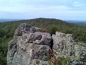 View of the top of Masema | |
| Highest point | |
| Absolute height | 1040.3 m |
| Location | |
| A country |
|
| The subject of the Russian Federation | Bashkortostan |
| Mountain system | Southern Urals |

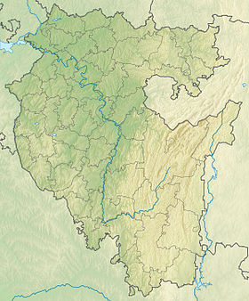
The most southern thousandth of the whole Ural range . The highest point of Burzyan district. It is located on the right bank of the Belaya to the west of the Bazal ridge and 16 km from the Kapova Cave in the Bashkir Reserve and the Altyn-Solok game reserve .
Masim is a popular point of tourist routes [2] . The republican program “Development of the tourism industry in the Burzyansky district of the Republic of Bashkortostan for 2008–2011” mentioned Mount Masim, noting that it is “repeatedly mentioned in the Bashkir epos and has significant resources for the development of hunting and horse tourism, the organization of extreme tourist travel” [3] .
Content
Feature
The length of the ridge is 28 km, the width is 3-4 km, the height is 1040 m (Masim). Addition - quartzites, quartz sandstones of the Zigalga suite of the Middle Riphean, carbonaceous shale of the Yushin Suite of the Riphean. It gives rise to the tributaries of the river Kuzha.
Landscapes - deciduous forests on light gray forest mountain soils and deciduous steppe forests in combination with lime-oak-maple. It is located in the Altyn Solok reserve.
Vertex Accessibility (s)
The ethnographer of S. I. Rudenko in the book “Bashkirs” reports that at the top of Mount Masim-Tau, he had to see “sacrifices made to the host-spirit of the mountain by those who rose upon it; most often the victims were either copper coins, tin or silver jewelry of women's breastplates, or, finally, pieces of cloth hung on trees or tied to a stick stuck in a crevice between the stones at the very top of the rock ” [4] .
On the Bashkir trips for the summer to the Masim mountain, S. I. Rudenko wrote in the book “Bashkirs”:
“Driving up to Mindigulov , we were fascinated by the amazing mountain view: the road began to descend far down, and when we descended, a wide green valley opened up before our eyes, bordered by two ridges of mountains, and in the valley beautiful White flowed when we went down the road, suddenly she was at our feet. Along one of its shores stretched bogatyr stone ridge. On the other side was a village deserted, silent; Bashkirs migrated from it for the summer to the neighboring mountains and, by the way, to the main one of them - Masim. The only Russian here was the parish clerk, it seems, Ostroumov. By chance, a forest conductor, also Russian, visited with him. Both told us that there was nothing to do in the village: neither the Bashkirs, nor the koumiss, nor food, but that we should go to the migrations to the Masim mountain, 18 miles from Mindegulova. We decided to go there "
Mount Masim has an altitude of 1040 km, length - 1 km. Top smooth, elongated. The eastern slopes are steep, the western slopes are gentle; there are rocks-remnants. The top is forested. It is composed of quartzites, quartz sandstones of the Zigalga Formation of the Middle Riphean.
Legends, the origin of the name
According to legends, the ruler of the union of 12 Bashkir tribes [5] lived on Mount Masim (according to other sources - 7 Bashkir clans [6] [7] ) - Masim Khan.
Confirmation of the version may be the fact that in these places there are other mountains and rocks, the names of which are associated with the Bashkir folklore: Babsakbey mountain, Karahyyyr mountain, Ataisal and others. The name of the main peak of Masima is called Kyzlar-Tash - “The Maiden's Stone”. Place of girls' holidays and rituals. According to legend, the name is associated with the pink color of the rocks.
Topographic maps
- Map sheet N-40-XXVIII . Scale: 1: 200 000. Specify the date of issue / state of the area .
Gallery
View from the Masimov cliffs to the north
Staircase to the top of Masema
Pink Masim Tau Rocks
Yaylyau (letnik) at the foot of Masim-tau
Notes
- Russian-Bashkir Dictionary of mountain objects of the Republic of Bashkortostan (Z. B. Latypova, Z. A. Sirazitdinov, Khisamitdinova F. G.)
- ↑ [1] Mausoleum of Tura Khan and Huseinbek
- ↑ [2] Order of the Government of the Republic of Belarus of June 25, 2007 No. 688-p On measures for the development of tourism infrastructure in the territory of the municipal district of Burzyansky District of the Republic of Bashkortostan. Archived March 13, 2014.
- ↑ Belsky expanses
- ↑ Article in Bashkortostan: a brief encyclopedia (Inaccessible link) . Archived October 30, 2013.
- ↑ Gabbas Davletshin. Masim Khan / Bashkort Aymagy, 1929, No. 7, p. 72-73.
- ↑ Babsak and Kusak. Bashkir folk epic.