Kholmsky district is an administrative-territorial unit ( district ) [5] , within the borders of which, instead of the abolished homonymous municipal district , the Kholmsky urban district [6] [7] municipality in the Sakhalin Region of Russia is formed .
| district [1] / city district [2] | |||||
| Kholmsky district (Kholmsky city district) | |||||
|---|---|---|---|---|---|
| |||||
| A country | Russia | ||||
| Included in | Sakhalin Oblast | ||||
| Includes | 24 settlements | ||||
| Adm. Centre | Kholmsk city | ||||
| Head of the municipality | Borovikov Vladimir Pavlovich | ||||
| History and Geography | |||||
| Date of formation | June 15, 1946 | ||||
| Square | 2279.04 [3] km² | ||||
| Timezone | MSK + 8 ( UTC + 11 ) | ||||
| Population | |||||
| Population | ↘ 36 568 [4] people ( 2019 ) | ||||
| Density | 16.05 people / km² | ||||
| Digital identifiers | |||||
| OKTMO | 64,754,000 | ||||
| Official site | |||||
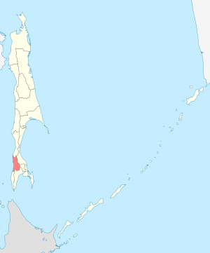 | |||||


The administrative center is the city of Kholmsk .
Content
Geography
The Kholmsky district is equated to the regions of the Far North . [eight]
Located in the southwestern part of the island. Sakhalin on the coast of the Tatar Strait .
History
On June 5, 1946, the Kholmsky district was formed as part of the South Sakhalin region of the Khabarovsk Territory . On January 2, 1947, the Yuzhno-Sakhalin Region was liquidated; its territory was included in the Sakhalin Region , which was withdrawn from the Khabarovsk Territory . In 1963 - 1965 it was abolished.
In June 2006, the homonymous municipal district, the municipality of Kholmsky district was transformed into the urban district, the municipality of “Kholmsky city district”.
Population
| Population | ||||||
|---|---|---|---|---|---|---|
| 2002 [9] | 2009 [10] | 2010 [11] | 2011 [12] | 2012 [13] | 2013 [14] | 2014 [15] |
| 35 141 | ↗ 44 776 | ↘ 41 925 | ↘ 41,781 | ↘ 40 884 | ↘ 40 001 | ↘ 39 179 |
| 2015 [16] | 2016 [17] | 2017 [18] | 2018 [19] | 2019 [4] | ||
| ↘ 38 789 | ↘ 38 371 | ↘ 37 877 | ↘ 37 295 | ↘ 36 568 | ||
District demographic development [20] [21]
| Year | Population | Birth | Deaths | E.p. | Migration |
|---|---|---|---|---|---|
| 2011 | 41,781 | 386 | 749 | -363 | -534 |
| 2012 | 40,884 | 392 | 730 | -338 | -545 |
| 2013 | 40 001 | 412 | 702 | -290 |
The composition of the urban district
The urban district includes 24 settlements:
| No. | Locality | Type of settlement | Population | Japanese name [23] |
|---|---|---|---|---|
| one | Baykovo | village | ↘ 0 [11] | Kurashi |
| 2 | Bambuchek | village | ↗ 17 [22] | Minamisen |
| 3 | Zyryansk | village | ↘ 6 [22] | Ohodomari |
| four | Kalinino | village | ↘ 35 [22] | Tarantomari |
| five | Kamyshevo | village | → 0 [11] | Takaraday |
| 6 | Kostroma | village | ↘ 1236 [22] | Konotoro |
| 7 | Krasnoyarsk | village | ↘ 19 [22] | Tobutsu |
| eight | Lublin | village | ↘ 11 [22] | Minamitomarichokkisi |
| 9 | Nikolaychuk | village | → 0 [11] | Ikenohata |
| ten | Novosibirsk | village | ↘ 92 [22] | Zueto |
| eleven | Ozhidaevo | village | ↘ 9 [22] | Nakano |
| 12 | Pavino | village | ↘ 35 [22] | Nijusango |
| 13 | Pioneers | village | ↘ 514 [22] | Habomayi |
| 14 | Pozharskoe | village | ↘ 79 [22] | Mizuho |
| 15 | true | village | ↘ 2031 [22] | Hiroti |
| sixteen | Surf | village | → 10 [22] | Tikonai |
| 17 | Pyatirechye | village | ↘ 398 [22] | Osaka |
| 18 | Sulfur Sources | village | → 42 [22] | Akeushi |
| nineteen | State farm | village | ↘ 154 [22] | Tomunaykisizawa |
| 20 | Kholmsk | city, administrative center | ↘ 27,479 [4] | Maoka (Mauka) |
| 21 | Chaplanovo | village | ↘ 778 [22] | Futomata |
| 22 | Chekhov | village | ↘ 3134 [22] | But yes |
| 23 | Pure | village | ↘ 122 [22] | Shimizu |
| 24 | Apple | village | ↘ 1716 [22] | Randomomary |
Notes
- ↑ from the point of view of the administrative-territorial structure
- ↑ from the point of view of the municipal structure
- ↑ Sakhalin region. The total land area of the municipality
- ↑ 1 2 3 Estimation of the population in the context of municipalities as of 01.01.2019 and the average annual rate for 2018 . Territorial authority of the Federal State Statistics Service for the Sakhalin Region (April 22, 2019). Date of treatment April 25, 2019. Archived April 25, 2019.
- ↑ Law of the Sakhalin Region "On the administrative-territorial structure of the Sakhalin Region" No. 25-ЗО of March 23, 2011
- ↑ Official names: "Municipal formation" Kholm city district "," Kholm city district "
- ↑ Charter of the municipality Kholm city district
- ↑ List of regions of the Far North and equivalent localities
- ↑ 2002 All-Russian Population Census. Tom. 1, table 4. The population of Russia, federal districts, constituent entities of the Russian Federation, regions, urban settlements, rural settlements - district centers and rural settlements with a population of 3 thousand or more . Archived February 3, 2012.
- ↑ The number of permanent population of the Russian Federation by cities, urban-type settlements and regions as of January 1, 2009 . Date of treatment January 2, 2014. Archived January 2, 2014.
- ↑ 1 2 3 4 2010 All-Russian Population Census. Sakhalin region. The population of urban districts, municipalities, urban and rural settlements, urban settlements, rural settlements . Date of treatment July 28, 2014. Archived July 28, 2014.
- ↑ Sakhalin region. Estimated resident population as of January 1, 2011-2016
- ↑ Population of the Russian Federation by municipalities. Table 35. Estimated resident population as of January 1, 2012 . Date of treatment May 31, 2014. Archived May 31, 2014.
- ↑ The population of the Russian Federation by municipalities as of January 1, 2013. - M.: Federal State Statistics Service of Rosstat, 2013. - 528 p. (Table 33. The population of urban districts, municipalities, urban and rural settlements, urban settlements, rural settlements) . Date of treatment November 16, 2013. Archived November 16, 2013.
- ↑ Table 33. The population of the Russian Federation by municipalities as of January 1, 2014 . Date of treatment August 2, 2014. Archived on August 2, 2014.
- ↑ The population of the Russian Federation by municipalities as of January 1, 2015 . Date of treatment August 6, 2015. Archived on August 6, 2015.
- ↑ Population of the Russian Federation by municipalities as of January 1, 2016
- ↑ The population of the Russian Federation by municipalities as of January 1, 2017 (July 31, 2017). Date of treatment July 31, 2017. Archived July 31, 2017.
- ↑ The population of the Russian Federation by municipalities as of January 1, 2018 . Date of treatment July 25, 2018. Archived July 26, 2018.
- ↑ Fertility is growing in the Kholmsky district
- ↑ Sakhalin Oblast
- ↑ 1 2 3 4 5 6 7 8 9 10 11 12 13 14 15 16 17 18 19 20 Operational forecast of emergencies for August 17, 2013 . Date of treatment September 24, 2014. Archived September 24, 2014.
- ↑ The names of many settlements in southern Sakhalin have the Japanese equivalent, despite the fact that these villages were founded by Russians at the end of the 19th century , and the original names are Russian (or Ainu , see for example A.P. Chekhov . Sakhalin Island). The Japanese gave their names after the capture of southern Sakhalin at the beginning of the 20th century