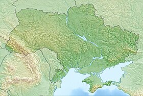
Kiev reservoir ( ukr. Kyivska Vodoshovische ) - reservoir on the Dnieper River to the north of Kiev . The area is 922 km².
| Kiev reservoir | |
|---|---|
| ukr Kyivska watershed | |
 Satellite image of the Kiev reservoir | |
| Morphometry | |
| Dimensions | 110 × 12 km |
| Square | 922 km² |
| Volume | 3.73 km³ |
| Deepest | 14.5 m |
| Specifications | |
| Year of filling | 1964-1966 |
| Pool | |
| Flowing streams | Dnepr , Pripyat , Teterev , Already , Irpen |
| Flowing stream | Dnieper |
| Location | |
| A country |
|
| Region | Kiev region |

In the north, it almost reaches the border with Belarus . The eastern part (territorially Chernihiv region ) is part of the Mezhrechensky regional landscape park , established in 2002 .
The Pripyat , Teterev , Uzh , Irpen and others rivers flow into the Kiev reservoir. The reservoir is a place for recreation and fishing [1] .
Feature

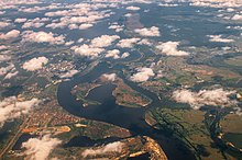


The reservoir was created in 1964-1966 and became the penultimate of six large reservoirs on the Dnieper. Its greatest width is 12 km. The dam was placed on the upper section of the Dnieper above Kiev near the city of Vyshgorod . It is located on the Dnieper - from Vyshgorod to with. Dnipro, on Pripyat - from the mouth to the city of Chernobyl and on the Grouse - from the mouth to the village. Bogdany. The reservoir area exceeds 922 km², the length is about 110 km, the greatest width is 12 km, in some places up to 3 km. The greatest depths (up to 15 m) are near the dam, the average depth (4.1 m) and shallow water (up to 2 m) occupy almost half of the entire area of the reservoir.
The difference in height is used by the Kiev Hydroelectric Power Plant to generate electricity .
Description
The territory of the Kiev reservoir can be divided into several sections, each of which has specific features. So, the Dnieper reach, located along the Dnieper channel above the confluence of the Dnieper and Pripyat, is very shallow. The same is characteristic of Pripyat Reaching, stretching along the channel of Pripyat above its mouth. The upper, or channel, parts of these reaches are the rivers themselves, with a slightly slower course and elevated water levels. By their characteristics, they differ little from the sections of the Dnieper and Pripyat, located above the zone of the reservoir.
The lower, extended parts of the layers have a lake-like character. Their shallow areas (up to 3 m) are abundantly overgrown with higher vegetation and algae. The waters of the Pripyat reach differ from the Dnieper waters due to their color due to the increased content of humic substances. Teterevsky ples is also shallow. But the influence of the Teterev waters on the water regime, as well as the flora and fauna of the reservoir is less noticeable than the Dnieper and Pripyat. This is due to the different water content of these rivers. With the waters of Teterev, a certain amount of substances of organic origin from domestic and industrial effluents causing water “bloom” is introduced into the reservoir.
The main pool of the reservoir, located below the confluence of the Dnieper and Pripyat, can be divided into three parts. The lower boundary of the upper part of the main body is with. Pissy Here shoals up to 3 m deep occupy almost 3/4 of the whole area. They are abundantly overgrown with higher vegetation and filamentous algae. This part of the main reach is greatly influenced by the overlying Dnieper and Pripyat stretches. That is why many of the water properties on the left side are similar to the properties of the Dnieper, and on the right - Pripyat waters.
The lower boundary of the middle part of the main reach is Rudnya-Tolokunskaya. The plot is deep. Squares with depths up to 3 m make up a little more than 1/3 of the area. The properties of water depend on the mixing of the waters of the upper part of the main and Grouse Reaches.
The lower part of the main reach, extending from. Rudnya-Tolokunskaya to the dam, the deepest. Shallow waters make up an insignificant part, so vegetation develops poorly.
Hydrology
During the year, the water level of the reservoir changes. It decreases from January to mid-March, then rises as a result of inflow of flood waters to mid-April, after which it falls again during April-June. Its increase is observed only at the beginning of winter, which is caused by autumn rains, and then the water level decreases again.
Depending on the level regime in the reservoir, there is a drainable zone and a zone of permanent flooding. Within the drained zone there are two subzones. The subzone of temporary flooding is expressed only in the upper part of the reservoir. It is flooded from mid-March to the end of June. Meadow vegetation develops on its territory. Fish come out for spawning here, animal and plant organisms develop abundantly, and after a water fall, they roll onto the reservoir, significantly affecting the vital activity of its various organisms and water quality. The temporary drainage subzone is located below the previous one. These territories are exempt from water only in early September, due to the fall in its level. They are overgrown with property amphibious vegetation.
Water exchange in the reservoir is carried out 9–12 times a year, depending on the volume of water coming from the Dnieper and Pripyat, during the period of flooding (April-May) the reservoir differs little from the river. Only with the establishment of summer low water in the Dnieper (end of June — July) does the flowage of the reservoir decrease, does it take a lake-like appearance. The water exchange rate in June — July has an impact on the development of water “blooming”: with good flowability, combined with low water mass and with some other factors, “flowering” of water develops to a lesser extent than with weak flowability and good warming of the water mass. A characteristic feature of the Kiev reservoir, located above all other Dnieper reservoirs, is that in spring there is a large difference in levels between the upper part of the reservoir and its main reach, which can reach 1.5—2 m. In summer, the water warms up to 20—24 ° C. The ice cover is established in December — January and lasts until the middle or end of March.
Ichthyofauna
Of the fish in the Kiev reservoir there are relatively few zherekh, white-eyed eyes, podust, chub, as well as nose, ruff, and ide, the breeding conditions of which have greatly deteriorated. The number of fish that lay eggs on plants has increased, since they are widely used in the reservoir for spawning as flood meadows at the top, and aquatic vegetation in shallow waters. Most often there are roach, bream , white bream , rudd, perch, blue bream , tench, pike, crucian carp.
Notes
- ↑ B. M. Kurkin, A. Ya. Shcherbukh. Kiev reservoir on the site of "Tsar fishing" . Fishking.ru. The appeal date was July 12, 2009. Archived February 17, 2012.
Literature
- Water Fund of Ukraine: Artificial reservoirs - reservoirs and ponds: A Handbook / Ed. V. K. Khilchevsky , V. V. Grebnya. - K .: Interpress, 2014. - 164 p. (ukr.) - ISBN 978-965-098-2