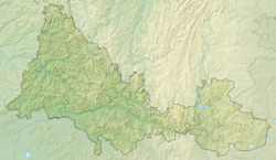
Zhusa ( obsolete. Djusa) [2] is a river in Russia , a left tributary of the Suunduk River. It flows in Adamovsky and Novoorsky districts of the Orenburg region. The source of the river is 2 km east of the village of Dzhusinsk , the mouth is 36 km along the left bank of the river Suunduk - Suundukoy branch of the Iriklinsky reservoir . The length of the river is 75 km [2] . 17 km from the mouth, the Kumustob River flows along the right bank, the other tributaries - the left: Koldar , Taubekty , right - Zhulamansai ; also low-flow beams: the right - Sadiq, Ashilsay, Alshinsay and the left - Beskryuk and Budamsha. From the source down on the river the settlements: Baymurat , Andreevka , Terensai , Slyudyanoy , Yubileyny and Dobrovolskoye .
| Zhusa | |
|---|---|
| Characteristic | |
| Length | 75 km |
| Pool | 1070 km² |
| Watercourse | |
| Source | |
| • Coordinates | |
| Mouth | Suunduk |
| • Location | 36 km on the left bank |
| • Coordinates | |
| Location | |
| Water system | Suunduk → Ural → Caspian Sea |
| A country |
|
| Region | Orenburg region |
| Areas | Adamovsky district , Novoorsky district |
| HWR Code | |
Water Registry Data
According to the state water register of Russia, it belongs to the Ural Basin District , the water management section of the river - the Urals from the Magnitogorsk hydroelectric complex to the Iriklinsky hydroelectric complex , the river sub-basin - the sub-basin is absent. The river basin is the Ural (the Russian part of the basin) [2] .
According to the geographic information system of water management zoning of the territory of the Russian Federation, prepared by the Federal Agency for Water Resources [2] :
Notes
- ↑ Surface water resources of the USSR: Hydrological knowledge. T. 12. The Lower Volga region and Western Kazakhstan. Issue 2. Ural-Emba region / ed. Z. G. Markova. - L .: Gidrometeoizdat, 1966. - 152 p.
- ↑ 1 2 3 4 State Water Register of the Russian Federation: Dzhusa . Archived August 24, 2012.
Links
- Map sheet M-40-23 Novoorsk . Scale: 1: 100,000. State of the area in 1984. 1985 edition