Ukhtoma - the river of the Vologda and Yaroslavl regions of Russia , the left tributary of the Sozhozha ( Volga basin), flows 29 km from the mouth. The river is 92 km long. The river is formed by the merger of Polygalka and Rybinka in the territory of the Gryazovets district of the Vologda region. The middle course runs through the Pervomaisky district of the Yaroslavl region, before the mouth the river flows into the territory of the Poshekhonsky district .
| Ukhtoma | |
|---|---|
 Basin of the Rybinsk Reservoir and White Lake Basin of the Rybinsk Reservoir and White Lake | |
| Characteristic | |
| Length | 92 km |
| Pool | 994 km² |
| Watercourse | |
| Source | |
| • Height | 154 m |
| • Coordinates | |
| Mouth | Mrs. |
| • Location | 29 km on the left bank |
| • Coordinates | |
| Location | |
| Water system | Sogozh → Volga → Caspian Sea |
| A country |
|
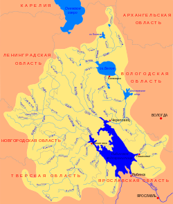
| Regions | Vologda region , Yaroslavl region |
| Areas | Gryazovets district , Pervomaisky district , Poshekhonsky district |
| HWR code | |
Water registry data
According to the state water register of Russia, it belongs to the Upper Volga Basin District , the water sector of the river is the Rybinsk Reservoir to the Rybinsk Hydroelectric Complex and the rivers flowing into it, without the Mologa , Suda and Sheksna Rivers from the source to the Sheksninsky Hydroelectric Complex , the river sub-basin is the Rivers of the Rybinsk Reservoir Basin. The river basin - (Upper) Volga to the Kuibyshev reservoir (without the Oka basin) [2] .
According to the geographic information system of water management zoning of the territory of the Russian Federation, prepared by the Federal Agency for Water Resources [2] :
- The code of the water body in the state water registry is 08010200412110000009908
- Hydrological Understanding (GI) Code - 110000990
- Pool code - 01/08/02.004
- GI Volume Number - 10
- GI Issue - 0
Tributaries
- 31 km: Kopsha river (lv)
- 37 km: Sheleksha river (lv)
- 39 km: Lyudinka river (ave.)
- 53 km: Kema river (lv)
- 79 km: Tyutesh river (lv)
Notes
- ↑ Surface Water Resources of the USSR: Hydrological Understanding. T. 10. Upper Volga region / ed. V.P. Shaban. - L .: Gidrometeoizdat, 1966 .-- 528 p.
- ↑ 1 2 State Water Register . Ukhtoma . textual.ru . Ministry of Natural Resources of Russia (March 29, 2009). Date of treatment December 20, 2018. Archived March 29, 2009.