Pohiyaha ( Ustara . Pohi-Yaha ) is a river in Russia , which flows through the Yamalo-Nenets Autonomous District . The river mouth is located on the 123rd km on the left bank of the Etypur River. The length is 75 km.
| Pohiyah | |
|---|---|
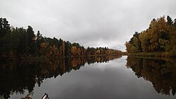 Pohiyah autumn. 5 km below the bridge Pohiyah autumn. 5 km below the bridge | |
| Characteristic | |
| Length | 75 km |
| Watercourse | |
| Source | |
| • Coordinates | |
| Mouth | Etypur |
| • Height | 59.5 m |
| • Coordinates | |
| Location | |
| Water system | Etypur → Ayvashedapur → Pur → Kara Sea |
| A country |
|
| Region | Yamalo-Nenets Autonomous District |
| HWR Code | |


The river is practically inaccessible due to the fact that it flows in places where there are no passing roads: the terrain along the banks is continuous impassable swamps. The most popular place on the river due to its availability is the bridge at the only intersection with a dirt road - a winter road that connects the village of Halyasavey with the rest of the world.
Content
Origin of title
Practically in all the rivers of the Yamalo-Nenets Autonomous Okrug, the name consists of one or two hyphenated words in the Nenets language.
As a rule, the first part speaks about the nature of the area, and the second part simply reports that this is a river. “Pohi-Yakha” is a combination of the words “Pukhacha Yakha”, pronounced in a singing tone, which literally translates to “old woman-river”.
Historical Information
It is believed that the first mention of this river was in 1820-1822. in a handwritten map of the area. The map appears in the book “Grigory Stroganov and the development of the lands of Siberia” by the author Belyaev I.
Bridges and crossings
Apart from the natural debris in the upper reaches of the river, the so-called “burned bridge” became the first permanent bridge across the river [2] . The bridge was built in the 1980s and made classically for oil and gas exploration sites. These are rejected and often new pipes used for oil production. The engineering solution is simple: the pipes are inserted into each other and welded to each other so that when crossing the bridge, the equipment does not fall into the river. Its name was due to the fact that the first bridge was built of wood, but was burned by local people who do not like the extraction of oil and gas.
Tributaries
Pohiyahi tributaries from the mouth to the source [3] :
- 20 km: Otayaha
- 25 km: Nyucha-Pohiyaha
- 30 km: Manayah
- 43 km: Tydeyaha
- 52 km: river without name
Water Registry Data
According to the state water register of Russia, it belongs to the Nizhneobsky Basin District , the water management section of the river - Pur , the river sub basin of the river - the sub basin. River basin - Pur [4] .
The object code in the state water register is 15040000112115300057374 [4] .
Notes
- ↑ Surface water resources of the USSR: Hydrological knowledge. T. 15. Altai and Western Siberia. Issue 3. The Lower Irtysh and Lower Ob / ed. G. D. Eyrich. - L .: Gidrometeoizdat, 1964. - 432 p.
- ↑ GPS coordinates of the Latitude of the bridge 63 ° 12'45.45 "С Longitude 77 ° 51'22.12" В
- ↑ Map sheet P-43-XI, XII Amputinka . Scale: 1: 200 000. State of the area in 1970. 1990 edition
- ↑ 1 2 State Water Register . Poha-Yaha . textual.ru . Ministry of Environment of Russia (March 29, 2009). The appeal date was December 20, 2018. Archived March 29, 2009.
Literature
- "Teachings of the Nenets language" G. N. Prokofiev (ed. 1936)
- “Nenets-Russian Dictionary” N. M. Tereshchenko, Uchpedgiz (published in 1955)
- Nenets, Entsy, Nganasans (North Samodian peoples) Vasilyev V.I. Peoples of the North and Siberia in the context of economic reforms and democratic transformations. M., 1994.
- Geography of the Yamalo-Nenets Autonomous District. Tyumen, 2001