Burtuy - a river in the Barguzinsky district of Buryatia , flows into the Lake Small Arangatuy , connected by the channel with the Chivyrkui Bay of Lake Baikal .
| Burtuy | |
|---|---|
 River View River View | |
| Characteristic | |
| Length | 16 km |
| Pool | 58 km² |
| Watercourse | |
| Source | |
| • Location | Svyatonossky range |
| • Coordinates | |
| Mouth | Small Arangatuy |
| • Coordinates | |
| Location | |
| Water system | Baikal → Angara → Yenisei → Kara Sea |
| A country |
|
| Region | Buryatia |
| Area | Barguzinsky Bay |
| HWR Code | |

Content
Geography
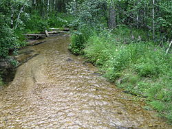
The length is 16 km, the basin area is 58 km² [2] . In the upper and middle reaches it has a mountainous character and runs in a stream along the southeastern slope of the watershed ridge of the Holy Nose Peninsula, in the lower (about 6 km) it flows along the flat swampy terrain of the Chivyrkuy isthmus , the Soft Carga tract, with a sharp slowing down of the current speed.
In the middle course, before entering the isthmus, the river is crossed by a country road leading to settlements on the bank of the Chivyrkuisky Bay - the settlements of Monakhovo , Katun , and Kurbulik . The width of the river here is on average 2–3 m. A kilometer in front of the estuary, the width of the river increases to 10–20 m, at the confluence of the Small Arangatui lake, the width reaches 60 m.
Attractions
The territory of the river valley is fully part of the Trans-Baikal National Park . The Buryat sanctuary is located on the middle course on its coast. The place near it is equipped for tourists. However, making fires, walking dogs, setting up tents, damaging the soil layer and collecting plants is prohibited.
Notes
- ↑ Surface water resources of the USSR: Hydrological knowledge. T. 16. Angaro-Yenisei district. Issue 3. Transbaikalia / ed. V.I. Zilberstein. - L .: Gidrometeoizdat, 1966. - 159 p.
- ГО RGO Novosibirsk. River Burtuy. (inaccessible link) . The date of circulation is December 16, 2015. Archived December 22, 2015.