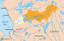
Eastmain ( Fr. Rivière de l'Eastmain ; English Eastmain River ) - a river in northwestern Quebec . The length is 756 km, the sources are in the center of the province, and the river flows into the James Bay . Eastmain - English East Main - East Maine is the old name for the eastern part of James Bay . The pool area is 46,400 km². At the mouth of the river is the village of Eastmaine, an indian Cree people [1] .
| Eastmain | |
|---|---|
| fr. Rivière de l'Eastmain Eastmain river | |
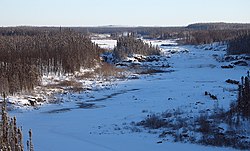 Eastmain River in December 2005. Eastmain River in December 2005. | |
| Characteristic | |
| Length | 756 km |
| Swimming pool | 46,400 km² |
| Watercourse | |
| Source | |
| • Coordinates | |
| Mouth | James Bay |
| • Height | 0 m |
| • Coordinates | |
| Location | |
| Water system | James Bay → Arctic Ocean |
| A country |
|
| Region | Quebec |

Content
- 1 Toponymy
- 2 Hydropower
- 2.1 Environmental concerns
- 2.2 Criticism of the project
- 3 Minerals in the river basin
- 4 See also
- 5 notes
- 6 References
Toponymy
The river got its name from the Hudson's Bay Company Branch in the East Maine region, which included the eastern and southern coasts of the Hudson's Bay . The oldest trading post of the Company was founded here in 1685.
Hydropower
Since the 1980s , most of the water has been diverted from the river and delivered through canals to one of the reservoirs of the James Bay project , Robert Burassa , owned by Hydro-Québec . The current runoff is significantly inferior to natural, due to which the river began to freeze in winter.
In the upper reaches of the river, hydraulic engineering continues under the James Bay and Northern Quebec Treaty (1975). In particular, the mirror area of the Eastmain Reservoir will be about 600 km², and the Eastmain-1 Hydroelectric Power Station will generate up to 900 MW of energy.
Environmental Issues
To ensure the unhindered life of the nekton (including fish) in the river, special channels were provided in the Eastmein-1 hydroelectric station construction through which the fish had to go around the dam, however, during the tests it was found that too high water flow rates in the channel do not allow fish climb upstream [2] .
Project Criticism
The implementation of the project for the transfer of water from the Eastmain River Basin led to a significant shallowing of the river in the lower reaches, which caused protests by local residents, including the Cree Indians [3] .
Minerals in the River Basin
In the basin of the Eastmain River there is a gold deposit of the same name ( Eastmain ), the potential ore reserves of which are estimated at 1,015,000 tons (gold content - 15 g / t). [four]
See also
- Hydro-québec
- James Bay Project
- List of Canada Rivers