Sita is a river in the Khabarovsk Territory in the Amur basin .
| Sita | |
|---|---|
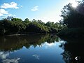
 Sita River near the village of Knyaz-Volkonskoye Sita River near the village of Knyaz-Volkonskoye | |
| Characteristic | |
| Length | 105 km |
| Swimming pool | 3320 km² |
| Watercourse | |
| Source [?] | swamps near the village of Sita |
| • Location | Lazo District |
| • Height | 184 m |
| • Coordinates | |
| Mouth | Peter and Paul Lake |
| • Height | 32 m |
| • Coordinates | |
| Location | |
| Water system | Peter and Paul Lake → Amur → Sea of Okhotsk |
| A country |
|
| Region | Khabarovsk region |
| HWR code | |

It flows out of the marshes near the village of Sita in the Lazo district . The river is 105 km long (159 km from the source of the largest tributary of Obora ).
Flowing through low-lying wetlands, it takes in small rivers and streams Dzhulikha , Malaya Sita 2nd , Kamenushka , Mad , Malaya Sita .
Between the villages of Blagodatnoye and Knyaz-Volkonskoye in the Khabarovsk region, it receives the Obor River, which is much more full-flowing, on the right. In the vicinity of the village of Knyaze-Volkonskoye, the Black River flows into the Sita River on the left.
Between the villages Blagodatnoye and Knyaz-Volkonskoye it forms a wide valley with a large number of old women , work is underway to produce gravel , and a dredger is working. In the valley of the river, on the site of a former gravel pit , the artificial Lake Blagodatnoe was formed , which is a resting place for local residents and Khabarovsk residents.
The Sita River floods violently during floods, flooding the low-lying wetland valley for many kilometers.
There is no shipping, exceptionally small.
Two reinforced concrete automobile bridges were built across the Sita River - in the vicinity of the villages of Blagodatnoye and Knyaz-Volkonskoye .
The river is a place of recreation and recreational fishing, river waters are selected for livestock complexes (technical water supply).
Fifteen kilometers below the village of Knyaze-Volkonskoye, the Sita River flows into the shallow Petropavlovsk Lake , which is connected by channels to the Amur River .

Sita River Flood
Sita River above the village of Blagodatnoe
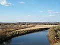
Sita River below the village of Blagodatnoe


Settlements by the River
Top down:
- 34 km (p. B.)
- Sita (l. B.)
- Grace (p. B.)
- Kalinka (l. B.)
- Prince Volkonskoye (p. B.)
- Sergeevka (l. B.)
- Red Banner (n. B.)
Literature
- Topographic atlas of the Khabarovsk Territory. Khabarovsk, 1994.
Links
- State Water Register of the Russian Federation: Sita (Arrow) . Date of treatment November 12, 2012. Archived November 22, 2012.