Rideau River is a river in Southern Ontario , flowing north from Lake Superior Rideau and flowing into the Ottawa River in the vicinity of Rideau Falls in Ottawa . The length of the river is 146 km. The name of the river in French means “curtain” - it is given in honor of the mentioned waterfalls, the appearance of which reminded S. de Champlain of the curtain.
| Rideau | |
|---|---|
| English Rideau river | |
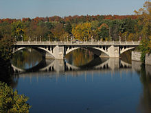
 Rapids at Rideau at Carleton University Rapids at Rideau at Carleton University | |
| Characteristic | |
| Length | 146 km |
| Watercourse | |
| Source | |
| • Coordinates | |
| Mouth | Ottawa |
| • Coordinates | |
| Location | |
| A country |
|
| Region | Ontario |


In the 1830s, the Rideau Canal was built, allowing access by water from Ottawa to Kingston on Lake Ontario . The canal connected Rideau with the Katarakvi River. The canal leaves the Rideau River in the Hogs Back Falls area in southern Ottawa .
In early spring, to reduce the risk of flooding in the lower reaches of the river, Ottawa municipal workers explode ice crust to clear ice on the surface of the river from Billings Bridge to Rideau Falls. This practice has been going on for over 100 years [1] .
Content
- 1 Cities
- 2 notes
- 3 Literature
- 4 References
Cities
The cities and municipalities are located along the river:
- Ottawa
- Manotik ;
- Kars ;
- Merrickville
- Smiths Falls .
Notes
- ↑ Leblanc, Daniel . Why Ottawa needs to blow up the Rideau River every year (February 28, 2011). Date of treatment March 1, 2011.
Literature
- Legget, Robert Ferguson (1986), Rideau Waterway , University of Toronto Press, ISBN 0802025730 , < https://books.google.ca/books?id=CaA4OpW4Ao0C&lpg=PP1&dq=Rideau%20Canal&pg=PP1#v=onepage&qft