Razvarnya - a river in Russia , flows in the Moscow region . Left tributary of the ridge . The length of the river is 19 km, the catchment area is 74.7 km².
| Fat | |
|---|---|
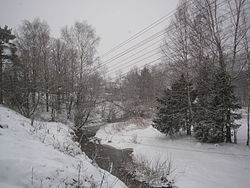 River near Denkovo River near Denkovo | |
| Characteristic | |
| Length | 19 km |
| Pool | 74.7 km² |
| Watercourse | |
| Source | |
| • Location | Istra district |
| • Coordinates | |
| Mouth | Ridge |
| • Location | Ruzsky urban district |
| • Coordinates | |
| Location | |
| Water system | Ridges → Ozerna → Ruza → Moscow → Oka → Volga → Caspian Sea |
| A country |
|
| Region | Moscow region |
| Areas | Istra district , Ruzsky urban district |
| HWR code | |

Content
Geography
The Razvarnya River originates in the Istra district . The source is located in the forests about 2 km east of the Fedorovka farm. It flows south, crosses the routes of the Riga direction of the Moscow Railway , Volokolamsk and Novorizhskoe Highways. The following settlements are located along the river: Denkovo , Davydkovo , Grebenki and Kolshino . The boil flows into the Gryad River near the village of Ivoylovo, Ruzsky urban district . It flows into the Ridge, 3.4 km from its mouth, near the village of Ivoilovo .
Water registry data
According to the state water register of Russia, it belongs to the Oka Basin District , the water sector of the river is Ozerna from the source to the Ozerninsky hydroelectric complex , the river sub-basin is the basins of the Oka tributaries to the Moksha inlet. The river basin of the river is the Oka [2] .
The code of the object in the state water registry is 09010101212110000023347 [2] .
See also
- List of rivers in the Moscow region
Notes
- ↑ Surface Water Resources of the USSR: Hydrological Understanding. T. 10. Upper Volga region / ed. V.P. Shaban. - L .: Gidrometeoizdat, 1966 .-- 528 p.
- ↑ 1 2 State Water Register . Boil . textual.ru . Ministry of Natural Resources of Russia (March 29, 2009). Date of treatment December 20, 2018. Archived March 29, 2009.