Sutka - a river in the Yaroslavl region of the Russian Federation , flows into the Rybinsk reservoir , 2764 km from the Volga estuary.
| Day | |
|---|---|
 Basin of the Rybinsk Reservoir and White Lake Basin of the Rybinsk Reservoir and White Lake | |
| Characteristic | |
| Length | 81 km |
| Pool | 609 km² |
| Watercourse | |
| Source | |
| • Coordinates | |
| Mouth | Rybinsk reservoir |
| • Location | 2764 km from the mouth of the Volga |
| • Coordinates | |
| Location | |
| Water system | Volga → Caspian Sea |
| A country |
|
| Region | Yaroslavskaya oblast |
| Areas | Myshkinsky District , Uglich District , Nekouz District |
| HWR code | |
Content
Description
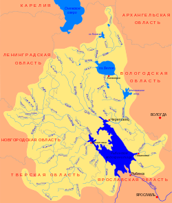
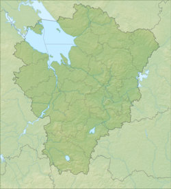
A day flows from a swamp near the Kozmodemyanka tract in the southern part of the Myshkinsky district and flows to the southeast. Near the village of Ushakovo, the Myshkinsky district, the river abruptly turns north; it flows near the village of Agerovo into the Volga spur of the Rybinsk reservoir [2] .
Previously, this river separated in the lower reaches the Myshkinsky district from Mologsky and flowed into the Volga with its two arms [2] .
The day has a length of 84 km with a catchment area of 580 square kilometers [2] . The width of the river bed is 10–25 m, and the depth is 0.5–4.5 m [2] . The lower section of the river is located in the backwater of the Rybinsk reservoir , this section is accessible for ships cruising along the Volga [2] . A ten-kilometer section (from the Verkhne-Nikulskoye pier) is included in the list of waterways of the Russian Federation [3] .
In the 19th century , a forest was fused along the river 50 miles upstream; also 5 mills worked on the Day. 57 villages were located along the banks [2] .
In the lower reaches of the river, near the village of Shestikhino , in the eroded root banks, Jurassic sands with the fauna of ammonites appear; this fauna is similar to the known exposure of the village of Glebovo on the Volga [2] .
In the middle and lower reaches, the river valley is attractive for recreation and fishing [2] .
History
The lands along the river were owned by the princes of Suda , one of the branches of the princes of Molozhsky .
Water registry data
Tributaries (km from the mouth)
- 40 km: Terenka river (lv)
- 51 km: Lomikha river (lv)
Notes
- ↑ Surface Water Resources of the USSR: Hydrological Understanding. T. 10. Upper Volga region / ed. V.P. Shaban. - L .: Gidrometeoizdat, 1966 .-- 528 p.
- ↑ 1 2 3 4 5 6 7 8 Sutka River - Yaroslavl Territory.
- ↑ List of inland waterways of the Russian Federation . Archived on October 18, 2012.
Literature
- Grechukhin V.A. On the rivers of the infamous . - Rybinsk: Rybinsk Compound, 2002 .-- 144 p. - 1,500 copies - ISBN 5-85231-116-2 . (about the rivers Sutka, Ild , Chesnava )
Links
- State Water Register: Day . Archived on May 26, 2012.