Ternei is an urban-type settlement in the north-east of Primorsky Krai , the administrative center of Terney district .
| Settlement | |
| Terney | |
|---|---|
 | |
| A country | |
| Subject of the federation | Primorsky Krai |
| Municipal district | Terney |
| Urban settlement | Terney |
| History and geography | |
| Based | 1908 |
| Former names | until 1922 - Gringmutovka until 1938 - Terney-Morozovsky |
| PGT with | 1938 |
| Square | 3.5 km² |
| Timezone | UTC + 10 |
| Population | |
| Population | ↘ 3311 [1] people ( 2018 ) |
| Digital identifiers | |
| Telephone code | +7 42374 |
| Postcode | 692150 |
| OKATO code | 05240551 |
| OKTMO code | |
Content
Geographical position
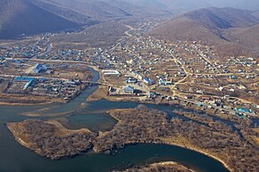
The village of Terney stands on the right bank of the Serebryanka River, three kilometers from its confluence with Serebryanka Bay, Sea of Japan .
The road to the village. Terney goes north from the village. Plastun , the distance to Plastun is about 58 km.
The distance by road to Vladivostok is 665 km, to Khabarovsk 640 km.
North of the village There is a road to the village of Malaya Kema ; the distance to Malaya Kema is 112 km.
From the Terney - Malaya Kema highway to the north-west there is a road to the villages of Tayozhnoye and Molodezhnoye of the Krasnoarmeysky district , the distance to Tayozhnoye is about 120 km, to Molodezhnoye about 160 km, there is no other highway to these remote settlements.
History
Terney Bay was opened to Europeans by Laperuse on June 23, 1787 , and it was named after the French navigator Admiral Charles d'Arsac de Ternay ( French: Baie de Ternay ). [2]
The village of Gringmutovka was founded in September 1908 , named after the immigrants in honor of the leader of the Black-Hundred movement Vladimir Gringmut who died in 1907 . [3] [4]
“The New Settlers Society on the shores of the Great Ocean decided to name their village Gringmutovsky. It not only does not have its own Orthodox church, but is also far from churches ... Archpriest John Vostorgov appealed to Muscovites to collect donations for the construction of the church, which the Grengmouth decided to name in memory of St. Prince. Vladimir ".
- Newspaper "Far Outskirts", 1909
In 1922, the village was renamed Terney-Morozovsky, and since 1938 it received the status of an urban-type settlement and the name Terney [5] .
Population
| Population | ||||||
|---|---|---|---|---|---|---|
| 1915 [6] | 1926 [7] | 1939 [8] | 1959 [9] | 1970 [10] | 1979 [11] | 1989 [12] |
| 145 | ↗ 246 | ↗ 3931 | ↘ 3236 | ↘ 2727 | ↗ 3717 | ↗ 4508 |
| 2002 [13] | 2005 [14] | 2009 [15] | 2010 [16] | 2011 [17] | 2012 [18] | 2013 [19] |
| ↘ 3971 | ↘ 3940 | ↘ 3908 | ↘ 3590 | ↘ 3585 | ↘ 3478 | ↘ 3426 |
| 2014 [20] | 2015 [21] | 2016 [22] | 2017 [23] | 2018 [1] | ||
| ↘ 3406 | ↘ 3360 | ↘ 3346 | ↘ 3318 | ↘ 3311 | ||
Climate
The village of Terney is equated to areas of the Far North , which is caused by economic reasons.
The climate is temperate monsoon .
Terney’s climate is somewhat harsher and sunny than the climate, located in similar geospatial conditions at the same 45 ° latitude, in the eastern Canadian city of St. John .
The temperature of winter (November-March) is about −7 ° C , summer (July-September) +16.4 ° C. The coldest month is January (−11.7 ° C), the warmest is August (+18.6 ° C). The summer is rainy, sometimes super-rainy - this is how July 2013 was remembered by the inhabitants of the village for record rains - 631 mm of rain fell, which is 5.4 monthly norm or 76% annual. [24] . For comparison, the average annual rainfall in St. Petersburg is about 662 mm.
| Climate Terney (norm 1981-2010) | |||||||||||||
|---|---|---|---|---|---|---|---|---|---|---|---|---|---|
| Indicator | Jan. | Feb | March | Apr | May | June | July | Aug | Sen | Oct. | Nov. | Dec | Year |
| Absolute Maximum, ° C | 7.3 | 9.4 | 20.1 | 26.4 | 31.5 | 36.6 | 38.1 | 36.5 | 30.8 | 26.0 | 17.1 | 9.3 | 38.1 |
| Average temperature, ° C | −11.7 | −8.2 | −2,4 | 3.8 | 8.2 | 12.0 | 16.2 | 18.6 | 14.4 | 7.4 | −2,2 | −9.6 | 3.9 |
| Absolute minimum, ° C | −28,6 | −26.4 | −25.6 | −11.3 | −4,6 | −1 | 1.9 | 6.9 | −3.5 | −9,8 | −21.7 | −26.9 | −28,6 |
| Precipitation rate, mm | 32 | 18 | 36 | 53 | 77 | 93 | 114 | 132 | 115 | 71 | 46 | thirty | 817 |
| Source: Tav ° C and precipitation [25] , Tmin ° C and Tmax ° C [26] [27] [28] | |||||||||||||
| Sunshine, hours per month [29] . | |||||||||||||
|---|---|---|---|---|---|---|---|---|---|---|---|---|---|
| Jan | Feb | Mar | Apr | May | Jun | Jul | Aug | Sen | Oct | But I | Dec | Year | |
| 185 | 198 | 216 | 193 | 191 | 146 | 149 | 162 | 211 | 224 | 201 | 172 | 2248 | |
| Climate of Terney (1961 - 1990) | |||||||||||||
|---|---|---|---|---|---|---|---|---|---|---|---|---|---|
| Indicator | Jan. | Feb | March | Apr | May | June | July | Aug | Sen | Oct. | Nov. | Dec | Year |
| Average temperature, ° C | −12 | −9.5 | −3 | 3.0 | 7.4 | 10.9 | 15.5 | 17.6 | 13.5 | 6.7 | −2,2 | −9.9 | 3.2 |
| Source: North Eurasian Climate Center | |||||||||||||
Notes
- ↑ 1 2 The population of the Russian Federation by municipalities as of January 1, 2018 . The appeal date was July 25, 2018. Archived July 26, 2018.
- ↑ La Pérouse, Jean François de Galaup, comte de (1831), de Lesseps, Jean Baptiste, ed., Voyage de Lapérouse, rédigé d'après ses manuscrits, suivi d'un appendice renfermant tout ce que l'on a découvert depuis le naufrage, et enrichi de notes par m. de Lesseps , p. 249,252-257 , < https://books.google.com/books?id=jLSxhmCvbVsC >
- ↑ Dyachkovsky - Labetsk .
- ↑ Far Eastern Monarchical Bulletin. Number 32
- ↑ N.P. InfoRost. GPIB | THE USSR. Administrative-territorial division of the Union republics: changes that occurred during the period from 1 / X 1938 to 1 / III 1939 - M., 1939. . elib.shpl.ru. The appeal date is December 13, 2018.
- ↑ Inhabited and inhabited places of the Primorsky region. Peasants. Aliens. Yellow : population census 1-20 June 1915 / Agriculture, Primorsky resettlement area, Statistical Dep. - Vladivostok: Type. Primorsky region Board, 1915. - XVI, 136 p.
- List of populated areas of the Far Eastern region According to the materials of the All-Union Population Census on December 17, 1926 and the Circumpolar Census 1926-1927
- All-Union census of 1939. The urban population of the USSR in urban settlements and inner-city areas . Circulation date November 30, 2013. Archived November 30, 2013.
- All-Union census of 1959. The urban population of the RSFSR, its territorial units, urban settlements and urban areas by sex . Demoscope Weekly. The date of circulation is September 25, 2013. Archived April 28, 2013.
- ↑ 1970 All-Union Population Census The urban population of the RSFSR, its territorial units, urban settlements and urban areas by sex. Demoscope Weekly. The date of circulation is September 25, 2013. Archived April 28, 2013.
- ↑ 1979 All-Union Population Census. The urban population of the RSFSR, its territorial units, urban settlements and urban areas by sex. Demoscope Weekly. The date of circulation is September 25, 2013. Archived April 28, 2013.
- All-Union Population Census 1989. Urban population . Archived August 22, 2011.
- ↑ All-Russian census of 2002. Tom. 1, table 4. The population of Russia, federal districts, constituent entities of the Russian Federation, districts, urban settlements, rural settlements — regional centers and rural settlements with a population of 3,000 or more . Archived on February 3, 2012.
- ↑ CD Territory: Primorsky Krai
- ↑ The resident population of the Russian Federation by cities, urban-type settlements and districts as of January 1, 2009 . The date of circulation is January 2, 2014. Archived January 2, 2014.
- ↑ Population of urban districts, municipalities, urban and rural settlements, urban settlements, rural settlements. The 2010 All-Russian Population Census (as of October 14, 2010). Primorsky Krai . The appeal date is August 31, 2013. Archived June 11, 2013.
- ↑ Primorsky Krai. Estimated resident population on January 1
- Population of the Russian Federation by municipalities. Table 35. Estimated number of resident population on January 1, 2012 . The date of circulation is May 31, 2014. Archived May 31, 2014.
- ↑ Population of the Russian Federation by municipalities as of January 1, 2013. - M .: Federal State Statistics Service Rosstat, 2013. - 528 p. (Table 33. Population of urban districts, municipal districts, urban and rural settlements, urban settlements, rural settlements) . The appeal date is November 16, 2013. Archived November 16, 2013.
- ↑ Table 33. The population of the Russian Federation by municipalities as of January 1, 2014 . Circulation date August 2, 2014. Archived August 2, 2014.
- ↑ Population of the Russian Federation by municipalities as of January 1, 2015 . Circulation date August 6, 2015. Archived August 6, 2015.
- Population of the Russian Federation by municipalities as of January 1, 2016
- ↑ Population of the Russian Federation by municipalities as of January 1, 2017 (July 31, 2017). The date of circulation is July 31, 2017. Archived July 31, 2017.
- ↑ On the east coast, the past month turned out to be not only the rainiest, but also the warmest over the entire observation period. (inaccessible link) . Date of treatment August 23, 2013. Archived on April 13, 2014.
- ↑ FSBI "VNIIGMI-WDC"
- ↑ Thermo-Karelia
- ↑ Primhydromet
- ↑ Weather and climate
- ↑ “The USSR Climate Guide” ( The USSR Climate Guide. Vol. 26. Primorsky Territory. Part 1. Solar radiation, radiation balance, and sunshine / Edited by V.K. Khramtsov. - L .: Gidrometizdat, 1966. - S. 57 .-- 78 p. ).