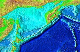
The Kuril-Kamchatka Trench (until the 1950s - the Tuskaror Basin) is a narrow deep-water trench in the Pacific Ocean , near the eastern underwater slopes of the Kuril Islands and the southern part of the Kamchatka Peninsula . Length 2170 km, average width 59 km. The maximum depth is 9717 m [1] ( ).
| Kuril-Kamchatka Trench | |
|---|---|
 | |
| Specifications | |
| Depth | 9717 m |
| Width | 59 km |
| Location | |
| Ocean | Pacific Ocean |

The boundaries of the depression approximately coincide with the isobath of 6000 m. The average steepness of the slopes is about 7 °. On the slopes - numerous ledges, terraces, as well as valleys descending to the maximum depth. The epicenter of many strong earthquakes [2] .
It was investigated mainly in the 1950s by Soviet expeditions on the Vityaz vessel.
See also
- Ulakhan fault
Literature
- Tectonics of the Kuril-Kamchatka deep-sea trench / Gnibidenko G.S. , Bykova T.G., Veselov O.V. et al .; Repl. ed. P.M.Sychev. - M.: Science , 1980.
- Belyaev G.M. Deep-sea oceanic trenches and their fauna . - M. , 1989.
Notes
- ↑ Kuril-Kamchatka Trench // Big Russian Encyclopedia : [in 35 vol.] / Ch. ed. Yu.S. Osipov . - M .: Great Russian Encyclopedia, 2004—2017.
- ↑ Analysis of the patterns of the distribution of earthquakes by types of focal movements in the Kuril-Okhotsk region before the catastrophic Simushir earthquake on 15. 11. 2006 - ...