Preobrazhenskaya Embankment - an embankment on the left bank of the Yauza River , in the Eastern Administrative District of Moscow on the territory of the Preobrazhenskoye District [1] . It lies between Bolshaya Semenovskaya and Preobrazhenskaya streets . It runs parallel to the Yauza River and Rusakovskaya Embankment (on the other side of the river). In the south, after the Semenovsky bridge , passes into the Semenovskaya embankment ; in the north, after the Sailor Bridge , goes to the promenade of Gannushkina . The numbering of houses is from Bolshaya Semenovskaya Street ( Electrozavodsky bridge over Yauza).
| Preobrazhenskaya Embankment | |
|---|---|
 | |
| general information | |
| A country | Russia |
| City | Moscow |
| County | VAO |
| Area | Preobrazhenskoye district |
| Underground | |
| Postcode | 107023 |

During the reconstruction, the exit of the 2nd Electrozavodsky Lane to Preobrazhenskaya Embankment was cleared and organized, and later paved.
Name Origin
This is the first name of the embankment. It was named so in 1925 according to the village of Preobrazhensky, located in this area.
History
The embankment is located in the Eastern administrative district of Moscow on the territory of the Preobrazhenskoye district.
In the scribe book of 1573-1574, the village of Mill was mentioned (it is also Sobakino). On the lands of this former village, the village of Preobrazhenskoye was formed in the second half of the 17th century.
- In the 1650s, this territory became the royal estate;
- in 1661, the wooden palace of Tsar Alexei Mikhailovich was built here.
Buildings and Structures
Bridges over Yauza
- Sailor's bridge .
- Two pedestrian bridges.
- Electrozavodsky bridge .
Odd side
|
|
|
|
|
Gallery
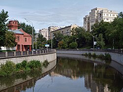
The river Hapilovka flows into Yauza
house 29-2
Building 21, p. 15 ...
... and about the same
house 23
house 25
Transport
Ground transportation
Public transport does not go along the street; the street is accessible from vehicles moving along Elektrozavodskaya street .
Beginning of the Embankment
- Stop " Electrozavodsky bridge "
- Bus : No. 80, No. 171 (final).
- Trolleybus : No. 14 (final).
Mid Quay
From the stop, walk along the 2nd Elektrozavodsky Lane to the embankment.
- Stop "2nd Electrozavodsky Lane" (towards "Transfiguration Square"):
- Bus : No. 80, No. 171.
- Trolleybus : No. 14.
- Stop "2nd Electrozavodsky Lane" (towards "Electrozavodsky Bridge"):
- Bus : No. 80, No. 171.
- Trolleybus : No. 14.
End of the Quay
- Stop "Preobrazhenskaya Square":
- Bus : No. 80, No. 171.
- Trolleybus : No. 14.
Rail Transport
- Platform of electric trains (electric trains) Elektrozavodskaya , Kazan direction of Russian Railways .
Nearest underground station
- Metro station "Preobrazhenskaya square" - towards "Preobrazhenskaya square".
- Metro station "Electrozavodskaya" - towards the "Electrozavodsky bridge".
Notes
- ↑ Transfiguration, Transfiguration Embankment. Archived on April 20, 2010.
Links
- Yandex Maps - Preobrazhenskaya Embankment
- Google Maps - Preobrazhenskaya Embankment
- WikiMapia - Preobrazhenskaya Embankment
- Maps openstreetmap - Preobrazhenskaya Embankment
- All-Moscow Classifier of Moscow Streets OMK UM: Preobrazhenskaya Embankment
- The names of Moscow streets . Toponymic Dictionary / R. A. Ageeva, G. P. Bondaruk, E. M. Pospelov and others; author foreword E.M. Pospelov. - M .: OGI, 2007. - (Moscow Library). - ISBN 5-94282-432-0 .
- Preobrazhenskaya Embankment: institutions and organizations.
- Photo of Preobrazhenskaya Embankment