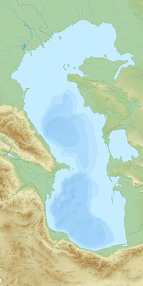
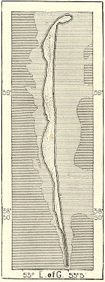
Ogurchinsky or Ogurdzhaly ( Turkmen. Ogurjaly adasy ) is a sandy island in the southeastern part of the Caspian Sea , the largest island of Turkmenistan , formerly the Turkmen SSR. Coordinates: 3906'0 s. w. 5306'0 in. The village stretches with a narrow oblique width of about 1-1.5 km and a length of about 42 km from north to south.
| Ogurchinsky | |
|---|---|
| Turkm. Ogurjaly adasy | |
| Specifications | |
| Square | 45 km² |
| Population | 0 pax (2012) |
| Location | |
| Water area | Caspian Sea |
| A country |
|
| Velayat | Balkan province |
Content
Title
The shape of the island resembles a cucumber, although the name itself comes from the name of the Ogurdzh tract in the Cheleken district, known since 1392 as a settlement of the late medieval Turkmen tribe of Ogurjaly [1] , letters. "Dashing people", "sea robbers." And indeed, in the XV — XVII centuries, sea pirates took refuge on the island, robbing caravans of Persian merchants and selling salt and stolen goods.
Geography
During severe winter storms, the waves of the Caspian Sea roll across the island in narrow places, changing its outlines. From the Cheleken Peninsula is separated by the Cheleken-Ogurchinsky Strait with a width of about 15 km. The island itself from the east borders the Turkmen Gulf with a width of about 40-60 km. The total area of about 45 km². [2] The surface is low with low sand dunes, sometimes overgrown with grass and shrubs.
In Soviet times, the island was turned into a wildlife sanctuary . Dzheyrans who were on the verge of extinction on the continent were brought here. A Caspian seal is found along the coastline, which successfully breeds here. [3]
Population
Permanent settlements are currently absent due to lack of water, but in the past there was a leper colony on the island for leprosy patients . Fishermen also stop on the island during fishing. [2] In Soviet times, their stay was severely limited.
At present, the settlement, located at the northern end of the island, is partially washed away - the waves of the Caspian washed out a new strait, forming many small islands [4] .
Notes
- ↑ S. Ataniyazov. Dictionary of Turkmen ethnonyms. Ashgabat, Ylym Publishing House, 1988
- ↑ 1 2 Ogurchinsky - an article from the Great Soviet Encyclopedia .
- ↑ Ogurchinsky Island , “The Gurchins Family Site”
- ↑ Google Earth