Chandyr (Turkic. “Lived, stringy meat”; in Jergelan in Iran) is a small dry river in Iran and Turkmenistan , the largest tributary of the Sumbar River (left), which in turn belongs to the Atrek basin and the Caspian Sea. The length is 120 km in spring and about 90 km in summer and autumn, the catchment area is about 1,820 km².
| Chandyr | |
|---|---|
| Characteristic | |
| Length | 120 km |
| Pool | 1820 km² |
| Watercourse | |
| Source | |
| • Coordinates | |
| Mouth | Sumbar |
| • Coordinates | |
| Location | |
| Water system | Sumbar → Atrek → Caspian Sea |
| Country |
|
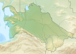
It starts on the southern slope of the Kopetdag mountains. Meals are mainly key and rain, to a lesser extent snow. In the summer in the lower reaches it dries out, since almost all the waters are used for irrigation and households. the needs of the oases, although a small underground runoff remains. The largest water discharge was registered during the flood in 1963 and amounted to about 4.22 m³ / s. [1] In places it serves as a border with Iran.
Attractions
A narrow side gorge Bezegly-Dere ( Garrygaly region ) departs from the Chandyr River with well-preserved rock paintings of ancient people hunting for representatives of the Kopetdag fauna. [2]
Notes
- ↑ Chandyr // The Great Soviet Encyclopedia : [in 30 t.] / Ch. ed. A. M. Prokhorov . - 3rd ed. - M .: Soviet Encyclopedia, 1969-1978.
- ↑ News - Erkin Turkmenistan (Free Turkmenistan) (Not available link) . The appeal date is April 7, 2010. Archived October 29, 2013.