Kukes ( Alb. Rrethi i Kukësit ) - one of the 36 districts of Albania , located in the north-eastern part of the country.
| district | |
| Kukes | |
|---|---|
| Alb. Rrethi i kukësit | |
| A country | |
| Included in | Kukes region |
| Adm. center | Kukes |
| History and Geography | |
| Area | 956 km² |
| Height | |
| Timezone | UTC + 1 , in summer UTC + 2 |
| Population | |
| Population | 64,000 people ( 2004 ) |
| Denominations | Islam |
| Digital identifiers | |
| ISO 3166-2 Code | |
 | |


The county covers an area of 956 km² and belongs to the Kukes region. The administrative center is the city of Kukes .
Before World War II, the district was closely connected with Kosovo . Prizren is only 60 km away. However, the post-war closure of Albanian borders led to the severance of these ties. After the withdrawal of the Serbian army from the border after the end of the war in Kosovo , tens of thousands of ethnic Albanians from Kosovo rushed here, seeking salvation.
Content
- 1 Geographical location
- 2 Economics and industry
- 3 Transport
- 4 Administrative divisions
- 5 notes
- 6 References
Geographical position
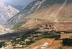
The county is located in the northeast of Albania in the highlands. To the east of the town of Kukes, the mountains reach a height of over 2400 m. The highest point is Mount Gjallica (2484 m).
The northern boundary of the district is the Drin River . In this part, it is dammed, forming the Fierza reservoir. From the south Black Drin flows into the reservoir, uniting here with the current White Drin from the east. The Drina Valley is as narrow and impregnable as many parts of the county.
In the east is the autonomous region of Serbia - Kosovo and Metohija . Near Morin, 39 km east of Kukes, in the White Drin Valley, is the main border crossing of Vrbnitsa between Albania and Kosovo.
Economics and Industry
To the east of Kukes, chromium is mined, and there are deposits of copper ores.
The population is engaged in agriculture. Kukes (18,000 inhabitants) is the only city in the county. Almost all residents are Sunni Muslims. On the eastern border, Gorans live in several villages.
Transport
Kukes has long been cut off from the rest of the country. Only narrow mountain roads leading through numerous passes connected the district with other cities, and in winter many villages were cut off from the outside world.
An airport has been built in Kukes, but there is virtually no air traffic. A new autobahn in Kosovo with a 5-kilometer underground tunnel passing through Kukes has significantly shortened the way here.
Albania is currently building a freeway from the largest Albanian port of Durres to Kukes. It is planned that in the future it will be extended to Pristina .
Administrative Division
The district is territorially divided into the city of Kukes and 14 communities: Arrën, Bicaj, Bushtrica, Grykë-Çaja, Kalis, Kolsh, Malzi, ишištěvac, Shtiqën, Surroj, Tërthor, Topojan, Ujmisht, Zapod .
Notes
- ↑ GeoNames - 2005.