Madang Province is the province of Papua New Guinea .
| Madang | |||
|---|---|---|---|
| English Madang province | |||
| |||
| A country | |||
| Included in | Momas region | ||
| Includes | Bogia County Madang County Middle Ramu County Rai Coast County Sumkar District Usino Bundi County | ||
| Adm. Centre | Madang | ||
| History and Geography | |||
| Square | 28 970 km² (7th place ) | ||
| Timezone | UTC + 10 | ||
| Population | |||
| Population | 493,906 [1] [2] [3] people ( 2011 ) ( 4th place ) | ||
| Density | 17.05 people / km² (15th place) | ||
| Digital identifiers | |||
| ISO 3166-2 Code | PG-MPM | ||
blank300.png | 300px]] 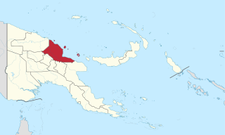  | |||

Content
Geography
Madang is a huge region that stretches from west to east for almost 300 km, and from north to south - for 160 km. Most of the province is located in the northeastern part of New Guinea . It also includes numerous coastal islands, the largest of which are Karkar , Long Island , Manam and Bagabag . The total area of the province is 28 970 km². The population of Madang is 493,906 people ( 2011 ).
The landscape of the province is represented mainly by mountainous terrain [4] . To the south are the Bismarck mountains , whose height exceeds 4000 m (the largest peak is Mount Wilhelm , whose height is 4509 m). In addition, in the south is the Ramu plain, which separates these mountains from the Finisterre ridge, located in the southeast of the province. The local mountains are covered with dense tropical forests, while the coastal plains washed by the New Guinea Sea represent a treeless area on which mainly coconut palms grow. Several large rivers flow through Madanga, including the Ramu , Soheram , Gogol and Malas .
The coastal islands that make up the province are usually of volcanic origin. They are still recorded volcanic activity, accompanied by volcanic eruptions .
History
The first people supposedly appeared on the island of New Guinea about 50 thousand years ago. As a result of archaeological excavations near the settlement of Simbai, an ancient settlement of people was found, which lived in this region about 12-15 thousand years ago. About 6 thousand years ago, immigrants from the island of Taiwan settled in the region, who reached New Guinea by sea. Representatives of the Papuan tribes Yabob ( Yabob ) and Bilbil ( Bilbil ) since ancient times used canoes and traded their pottery from the island of Karkar with residents of the western part of the modern province of Morobe .
For the first time, the coast of Madang was investigated in detail by the Russian ethnographer Nikolai Nikolayevich Miklukho-Maklai . This happened in 1871 . In 1884, the first German merchants appeared in the region who actively traded with local residents or built local plantations on which coffee, tobacco and cotton were grown. At the end of the 19th and beginning of the 20th centuries Christian missionaries settled in Madang.
In 1914, the island of New Guinea came under the control of Australia , which since 1921 ruled it as part of the Trust Territory under the mandate of the League of Nations . During the Second World War, large battles of Australian and American forces with the Japanese armed forces were waged in the province, which, however, were completely defeated by 1945 .
Since 1975, the territory of the modern province of Madang has been part of the independent state of Papua New Guinea .
Economics
The basis of the local economy is agriculture (primarily the production of cocoa and copra ) [5] . At the same time, the industrial sector and the services sector are developing.
Notes
- ↑ Census - (2011) Geohive
- ↑ Population Census - (2011) City Population
- ↑ Census - (2011) Png Nso
- ↑ Madang Province (inaccessible link) . Ministry of Inter Government Relations. Date of treatment April 4, 2010. Archived April 22, 2012.
- ↑ Madang Province (inaccessible link) . PNG Holidays. Date of treatment April 4, 2010. Archived April 22, 2012.