South Island ( Eng. South Island , Maori Te Wai-pounamu [1] ) - the largest of the two largest islands in New Zealand ; the second largest, but more densely populated, is the North Island . The islands are separated by the Cook Strait , the west coast is washed by the Tasman Sea , the eastern and southern Pacific Ocean . The area of the South Island is 150,437 square kilometers (58,084 sq. Miles) [2] , making it the 12th largest in the world . The island has a temperate climate .
| South island | |
|---|---|
| English South Island , Maori Te Wai-pounamu | |
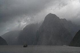 Milford sound | |
| Specifications | |
| Square | 150 437 km² |
| Highest point | 3724 m |
| Population | 1,038,600 (2010) |
| Population density | 6.9 people / km² |
| Location | |
| Water area | Pacific Ocean |
| A country |
|

South Island is 32 percent larger in size than North Island, but only 23 percent of New Zealand’s population lives here. In the early stages of European colonization, most of the European population lived on the South Island due to the “gold rush” that began in the 1860s. The population of the North Island exceeded the population of the South at the beginning of the 20th century, and throughout the century there has been internal migration to the North. [3]
Title
On maps of the 19th century, the island was referred to as Middle or New Muenster Island , while the name South Island was used for modern Stuart . In 1907, an official government announcement was issued to abandon the use of the name Middle Island . [four]
Although the island has been known as the South for many years, in 2009 the New Zealand Geographic Names Council reported that the South Island still did not have an official name [5] . After consultation with the public, the commission officially approved the modern name South Island, or Te Waipounamu, in October 2013 [6] .
History
Human Appearance
Charcoal drawings can be found in limestone caves in the central part of the South Island. More than 500 drawings are known on the territory [7] , stretching from Kaikoura to Northern Otago. Their age is estimated from 500 to 800 years. They depict animals, people, and fantastic creatures, possibly stylized reptiles [8] . Some of the birds in the photo have long died out, including the moa and Haast eagles . By the time the Europeans arrived, the local Maori did not know the origin of the drawings [9] .
Classic Maori period
The Appearance of Europeans
The first of the Europeans to reach the South Island was the crew of the Dutch explorer Abel Tasman . In December 1642, Tasman anchored at the northern tip of the island in Golden Bay , which he called Murderers Bay after a clash with Maori. He plotted the west coast of the two main islands. Tasman named them Staten Landt , in honor of the General States of the Netherlands , and this name appeared on the first maps of the country. Dutch cartographers changed their name to Nova Zeelandia in honor of the Dutch province of Zealand . Subsequently, it was Anglicized as New Zealand by the British captain Cook , who visited the islands more than 100 years after Tasman (1769-1770).
The first European settlement on the South Island was founded in 1823 by James Spencer, a veteran of the Battle of Waterloo . [ten]
In January 1827, the French explorer Jules Dumont-Durville arrived in Tasman Bay on the corvette Astrolabe . A number of geographical names around the Gulf of Tasman were given by Durville and his crew, including the island of d'Urville , French Pass Strait . [eleven]
European settlements
When Great Britain annexed New Zealand in 1840, the South Island briefly became part of the New South Wales colony. [12] This annexation was a response to France’s attempts to establish a colony on the South Island in Acaroa [13] and the New Zealand company in Wellington , and therefore Governor General William Hobson proclaimed British sovereignty over all of New Zealand on May 21, 1840.
On June 17, 1843, Māori natives and British settlers clashed in the Wairau Valley, an event known as the Wairau incident . This was the first serious clash between the parties after the signing of the Waitangi agreement , and the only one that occurred in the south of the island. Four Māori were killed and three were injured in the incident, while 22 people were killed and five wounded among Europeans. [14]
The settlement of Otago, organized by the Free Church of Scotland, began to form in March 1848 with the arrival of the first two immigrant ships from Greenock - John Wickliffe and Philip Laing . Captain William Cargill, a veteran of the Iberian War, became the first colony leader.
While New Zealand land wars of the 1860s and 1870s were on the North Island , the situation on the South Island, where there were few Maori settlements, was more peaceful. In 1861, gold deposits were discovered in Gabriel Galli in Central Otago, causing a gold rush. Dunedin became the richest city in the country, and many residents were outraged by the need to finance the wars of the North Island. In 1865, parliament discussed the independence of the South Island. The initiative was defeated, receiving support from 17 votes out of 31.
In the 1860s, several thousand Chinese, mainly from Guangdong , moved to New Zealand to work on the gold mines of the South Island .. Although the first Chinese migrants were invited by the government of the province of Otago , special laws were soon adopted to restrict migration from Of Asia. [15]
Earthquakes 2010—2011
September 2010
An earthquake of magnitude 7.1 occurred on the South Island of New Zealand on Saturday at 04:35 AM local time, September 4, 2010 (16:35 GMT, September 3, 2010). [16] An earthquake occurred at a depth of 10 kilometers (6.2 miles), no one was killed.
The epicenter was located 40 kilometers west of Christchurch; 10 kilometers (6.2 miles) southeast of Darfield [17]
Sewers were damaged, [18] gas and water lines were broken, up to 75% of the city was de-energized. [19] Among the facilities affected by the lack of electricity was Christchurch Hospital , which was forced to use backup generators immediately after the earthquake. [nineteen]
Christchurch Airport was closed after the earthquake, all flights were canceled. It was reopened at 1:30 pm after inspecting the main runway. [20]
Earthquakes were reported to have caused enormous damage and led to power outages. 63 aftershocks were also recorded in the first 48 hours after the earthquake. The total insurance cost of this natural disaster, according to the Treasury of New Zealand, reaches $ 11 billion. [21] [22]
February 2011
A powerful aftershock of magnitude 6.3 occurred on February 22, 2011. The epicenter was located 10 kilometers southeast of Christchurch, at a depth of 5 km. [23] Although this time the magnitude was inferior to the 2010 earthquake, this earthquake was recognized as one of the strongest ever recorded in the world in a populated urban area due to its shallow depth and proximity to the epicenter. [24] Preliminary estimates indicated that about a third of the buildings in the central business district should be demolished.
Unlike the events of September 2010, the earthquake in February 2011 occurred on a busy weekday. This, along with proximity to the city center, led to the death of 181 people. [25]
For the first time in the history of New Zealand, a national emergency was introduced. Many of the city’s buildings were seriously damaged, including the famous Christchurch Cathedral .
June 2011
On June 13, 2011, at about 1:00 New Zealand time, Christchurch shakes an earthquake of magnitude 5.7, an earthquake of magnitude 6.3 (according to the original information 6.0) at 2:20 pm, with the epicenter in the same place as the February earthquake. Several dozen tremors occurred in the following days, including several with a magnitude of more than 4.
Telephone lines and power were destroyed in some suburbs. [26]
After the earthquake, only one death was recorded, but there were many injured.
Geography
The South Island, with an area of 150.437 square kilometers (58 sq. Miles), is New Zealand's largest land mass; it is the 12th largest island in the world . It is divided along its length by the Southern Alps , the highest peak of which is Aoraki / Mount Cook with a height of 3,724 meters. Eighteen peaks with a height of more than 3,000 meters (9800 feet) are on the South Island. The Canterbury Plain occupies the eastern part of the island. The landscapes of the South Island made it an ideal place to create some films , including The Lord of the Rings and the Chronicles of Narnia: the Lion, the Witch and the wardrobe . The island is located at the same latitudes. like Tasmania and Patagonia in South America .
Climate
The climate of the island is mostly temperate . The average temperature on the South Island is 8 ° С [27] January and February are the warmest months, and July is the coldest. [28]
Climatic conditions vary dramatically across regions from very humid on the west coast to semi-arid in the interior of Canterbury . Christchurch is the driest city, receiving about 640 mm of rain annually, while Invercargill is the wettest, receiving about 1150 mm.
Political structure
The two-level structure established under the Law on Local Self-Government in 2002 establishes seven regional councils on the management of regional environmental and transport issues on the South Island (and neighboring islands), and 25 territorial administrations that carry out the construction of roads, sewers, and issuance of building permits and other issues. Four territorial councils (one city and three districts) also serve as a regional council and are known as unitary bodies.
Administrative Division
There are 23 territorial administrations within the South Island: 4 city councils and 19 district councils.
| Name | Seat | Area (km 2 ) [29] | Population | Density (per km 2 ) | Region (s) |
|---|---|---|---|---|---|
| Ashburton district | Ashburton | 6208 | Template: NZpopulationdata | {{rnd / b <strongclass = "error"> Expression "[" | <strongclass = "error"> Expression error: unrecognized punctuation character "[" | 2 | 1}} | Canterbury |
| Buller district | Westport | 7950 | Template: NZpopulationdata | {{rnd / b <strongclass = "error"> Expression "[" | <strongclass = "error"> Expression error: unrecognized punctuation character "[" | 2 | 1}} | West coast |
| Central otago district | Alexandra | 9966 | Template: NZpopulationdata | {{rnd / b <strongclass = "error"> Expression "[" | <strongclass = "error"> Expression error: unrecognized punctuation character "[" | 2 | 1}} | Otago |
| Christchurch city | Christchurch | 1610 | Template: NZpopulationdata | {{rnd / b <strongclass = "error"> Expression "[" | <strongclass = "error"> Expression error: unrecognized punctuation character "[" | 2 | 1}} | Canterbury |
| Clutha district | Balclutha | 6406 | Template: NZpopulationdata | {{rnd / b <strongclass = "error"> Expression "[" | <strongclass = "error"> Expression error: unrecognized punctuation character "[" | 2 | 1}} | Otago |
| Dunedin city | Dunedin | 3340 | Template: NZpopulationdata | {{rnd / b <strongclass = "error"> Expression "[" | <strongclass = "error"> Expression error: unrecognized punctuation character "[" | 2 | 1}} | Otago |
| Gore district | Gore | 1251 | Template: NZpopulationdata | {{rnd / b <strongclass = "error"> Expression "[" | <strongclass = "error"> Expression error: unrecognized punctuation character "[" | 2 | 1}} | Southland |
| Gray district | Greymouth | 3516 | Template: NZpopulationdata | {{rnd / b <strongclass = "error"> Expression "[" | <strongclass = "error"> Expression error: unrecognized punctuation character "[" | 2 | 1}} | West coast |
| Hurunui district | Amberley | 8661 | Template: NZpopulationdata | {{rnd / b <strongclass = "error"> Expression "[" | <strongclass = "error"> Expression error: unrecognized punctuation character "[" | 2 | 1}} | Canterbury |
| Invercargill city | Invercargill | 491 | Template: NZpopulationdata | {{rnd / b <strongclass = "error"> Expression "[" | <strongclass = "error"> Expression error: unrecognized punctuation character "[" | 2 | 1}} | Southland |
| Kaikoura District | Kaikoura | 2050 | Template: NZpopulationdata | {{rnd / b <strongclass = "error"> Expression "[" | <strongclass = "error"> Expression error: unrecognized punctuation character "[" | 2 | 1}} | Canterbury |
| Mackenzie district | Fairlie | 7442 | Template: NZpopulationdata | {{rnd / b <strongclass = "error"> Expression "[" | <strongclass = "error"> Expression error: unrecognized punctuation character "[" | 2 | 1}} | Canterbury |
| Marlborough district | Blenheim | 12 484 | Template: NZpopulationdata | {{rnd / b <strongclass = "error"> Expression "[" | <strongclass = "error"> Expression error: unrecognized punctuation character "[" | 2 | 1}} | unitary authority |
| Nelson city | Nelson | 445 | Template: NZpopulationdata | {{rnd / b <strongclass = "error"> Expression "[" | <strongclass = "error"> Expression error: unrecognized punctuation character "[" | 2 | 1}} | unitary authority |
| Queenstown-Lakes District | Queenstown | 9368 | Template: NZpopulationdata | {{rnd / b <strongclass = "error"> Expression "[" | <strongclass = "error"> Expression error: unrecognized punctuation character "[" | 2 | 1}} | Otago |
| Selwyn district | Rolleston | 6557 | Template: NZpopulationdata | {{rnd / b <strongclass = "error"> Expression "[" | <strongclass = "error"> Expression error: unrecognized punctuation character "[" | 2 | 1}} | Canterbury |
| Southland district | Invercargill | 32 605 | Template: NZpopulationdata | {{rnd / b <strongclass = "error"> Expression "[" | <strongclass = "error"> Expression error: unrecognized punctuation character "[" | 2 | 1}} | Southland |
| Tasman district | Richmond | 9786 | Template: NZpopulationdata | {{rnd / b <strongclass = "error"> Expression "[" | <strongclass = "error"> Expression error: unrecognized punctuation character "[" | 2 | 1}} | unitary authority |
| Timaru district | Timaru | 2726 | Template: NZpopulationdata | {{rnd / b <strongclass = "error"> Expression "[" | <strongclass = "error"> Expression error: unrecognized punctuation character "[" | 2 | 1}} | Canterbury |
| Waimakariri district | Rangiora | 2216 | Template: NZpopulationdata | {{rnd/b<strongclass="error">Ошибкавыражения:неопознанныйсимволпунктуации«[»|<strongclass="error">Ошибкавыражения:неопознанныйсимволпунктуации«[»|2|1}} | Canterbury |
| Waimate District | Waimate | 3577 | Шаблон:NZpopulationdata | {{rnd/b<strongclass="error">Ошибкавыражения:неопознанныйсимволпунктуации«[»|<strongclass="error">Ошибкавыражения:неопознанныйсимволпунктуации«[»|2|1}} | Canterbury |
| Waitaki District | Oamaru | 7212 | Шаблон:NZpopulationdata | {{rnd/b<strongclass="error">Ошибкавыражения:неопознанныйсимволпунктуации«[»|<strongclass="error">Ошибкавыражения:неопознанныйсимволпунктуации«[»|2|1}} | Canterbury (59.61 %) Otago (40.39 %) |
| Westland District | Hokitika | 11 870 | Шаблон:NZpopulationdata | {{rnd/b<strongclass="error">Ошибкавыражения:неопознанныйсимволпунктуации«[»|<strongclass="error">Ошибкавыражения:неопознанныйсимволпунктуации«[»|2|1}} | West Coast |
Урбанизация
На Южном острове есть 14 городов с населением более 10 тысяч:
| title | Population (Июнь 2018 года) |
|---|---|
| Christchurch | 377200 |
| Данидин | 104500 |
| нельсон | 49300 |
| Инверкаргилл | 48700 |
| Timaru | 28300 |
| Бленхейм | 26400 |
| Ашбертон | 19600 |
| Рангиора | 18400 |
| Роллстон | 16350 |
| Квинстаун | 15650 |
| Richmond | 15,000 |
| Mosgiel | 13400 |
| Оамару | 13150 |
| Каиапои | 11850 |
Economics
На Южном острове экономика ориентирована на туризм и развитие первичного сектора экономики , в частности, сельского хозяйства.
ВРП Южного острова оценивается в 61,5 млрд долларов в 2017 году, 22,7 % от национального ВВП Новой Зеландии. [thirty]
Энергетика
Южный остров является крупным центром по выработке электроэнергии, имеется развитая гидроэнергетика. В 2010 году остров произвел 18,010 ГВтч электроэнергии, 41,5 % от общей выработки Новой Зеландии. Почти вся (98.7 %) электроэнергия острова вырабатывается на ГЭС. [31]
Три крупные ГЭС острова: Уаитаки , Клута , и Манапоури , вместе производят около 92 процентов электроэнергии на острове.
Transport
Road Transport
Протяженность автомобильных дорог острова составляет 4 921 километр.
Rail Transport
Железнодорожная сеть имеет две основные линии: Главная Северная линия из Пиктона в Крайстчерч и на Главная Южная линии из Литтелтона в Инверкаргилл через Данидин.
- ↑ Reporter. Two official options for NZ island names . The New Zealand Herald (October 10, 2013). Date of treatment December 20, 2018.
- ↑ Quick Facts - Land and Environment : Geography - Physical Features (недоступная ссылка) . Statistics New Zealand (2000). Дата обращения 13 августа 2012. Архивировано 8 апреля 2013 года.
- ↑ King, Michael. The Penguin History of New Zealand. — Auckland : Penguin Books, 2003. — P. 280–281. — ISBN 978-0-14-301867-4 .
- ↑ The Waitara Harbour Bill . Taranaki Herald (30 July 1907).
- ↑ The New Zealand Geographic Board Considers North and South Island Names (недоступная ссылка) . Land Information New Zealand. Дата обращения 10 октября 2013. Архивировано 14 февраля 2013 года.
- ↑ Two official options for NZ island names . NZ Herald (10 October 2013). Date of treatment October 10, 2013.
- ↑ Very Old Maori Rock Drawings (недоступная ссылка) . Natural Heritage Collection. Дата обращения 15 февраля 2009. Архивировано 24 февраля 2009 года.
- ↑ The SRARNZ Logo (недоступная ссылка — история ) . Society for Research on Amphibians and Reptiles in New Zealand. Дата обращения 15 февраля 2009.
- ↑ Keith, Hamish. The Big Picture: A history of New Zealand art from. 1642. — 2007. — P. 11–16. — ISBN 978-1-86962-132-2 .
- ↑ Bluff history — an overview (недоступная ссылка) . Дата обращения 4 апреля 2019. Архивировано 14 октября 2008 года. (from the 'bluff.co.nz' website. Retrieved 14 December 2008.)
- ↑ D'Urville's Tasman Bay Odyssey . theprow.org.nz .
- ↑ А. Х. Маклинток (ред.), энциклопедия Новой Зеландии", 3 тт., Веллингтон, Новая Зеландия: Р. Э. Оуэн, правительства принтера, 1966, т. 3 С. 526.'
- ↑ Robbie Whitmore. French colonists - New Zealand in History . history-nz.org .
- ↑ Michael King. The Penguin History of New Zealand. — Penguin Books, 2003. — ISBN 978-0-14-301867-4 .
- ↑ Manying Ip. 'Chinese', Te Ara—the Encyclopedia of New Zealand, updated 21 December 2006, http://www.TeAra.govt.nz/NewZealanders/NewZealandPeoples/Chinese/en Архивировано 24 февраля 2007 года.
- ↑
- ↑ New Zealand earthquake report - Sep 4 2010 at 4:35 am (NZST) (link not available) . GeoNet . Earthquake Commission and GNS Science (September 4, 2010). Date of treatment September 6, 2010. Archived on September 5, 2010.
- ↑ New Zealand Quake Victims Say 'It was terrifying' . The Epoch Times (September 3, 2010). Date of treatment September 4, 2010.
- ↑ 1 2 New Zealand's South Island Rocked by Magnitude 7.0 Earthquake . Bloomberg (September 3, 2010). Date of treatment September 4, 2010.
- ↑ Published: 9:08 am Saturday 4 September 2010. State of emergency declared after quake hits Chch | NATIONAL News (inaccessible link) . Tvnz.co.nz. Date of treatment September 4, 2010. Archived on September 7, 2010.
- ↑ Canterbury shaken by 240 aftershocks . Stuff (September 8, 2010). Date of treatment September 8, 2010.
- ↑ Multiple fatalities in New Zealand earthquake near Christchurch (Link not available) . Daily Telegraph (February 22, 2011). Date of treatment February 22, 2011. Archived on October 7, 2012.
- ↑ New Zealand Earthquake Report - Feb 22, 2011 at 12:51 pm (NZDT) unopened) link not available) . GeoNet . Earthquake Commission and GNS Science (February 22, 2011). Date of treatment February 22, 2011. Archived February 23, 2011.
- ↑ Fox. Building code no match for earthquake . The Dominion Post (March 1, 2011). Date of treatment July 11, 2011.
- ↑ List of deceased . New Zealand Police (1 June 2011). Date of treatment July 11, 2011.
- ↑ Archived copy (inaccessible link) . Date of treatment August 21, 2011. Archived on September 19, 2012. Christchurch aftershocks: Hard-hit east residents three times unlucky
- ↑ From Niva Climate Science Review .
- ↑ Summary of New Zealand climate extremes unspecified (link not available) . National Institute of Water and Atmospheric Research (2004). Date of treatment February 17, 2008. Archived January 13, 2009.
- ↑ Living Density: Table 1 (unreachable link) . Date of treatment April 4, 2019. Archived November 28, 2007. , Housing Statistics, Statistics New Zealand. Retrieved January 25, 2009. Areas are based on 2001 boundaries. Water bodies greater than 15 hectares are excluded.
- ↑ Regional gross domestic product: Year ended March 2017 - Stats NZ . www.stats.govt.nz .
- ↑ Energy Data File . Ministry of Economic Development (July 13, 2011).