Scabland is the territory of the glacial and glacial zones, exposed or previously subjected to repeated exposure to catastrophic superfluids (diluvial flows, floods, flood streams, megafloods) from glacier-dammed lakes that left the original erosive, evorious and accumulative ( diluvium ) formations, from which it is possible to reconstruct the history and give a forecast [1] . Scabland is a territory dissected by parallel hollows, teeming with drop-shaped hills in the plan, water-emitting (evorionic) boilers and traces of cavitation ; in the words of M. G. Groswald , this is a geomorphological landscape created by a hydrosphere catastrophe [2] .
Content
- 1 History of the term
- 2 Scabland structure
- 2.1 Diluvial erosion
- 2.2 Diluvial evorasia
- 2.3 Dilyuvial accumulation
- 3 Illustrations
- 4 notes
- 5 Literature
- 6 References
History of the term
When introducing new terms for describing catastrophic discharges from glacial lakes of various types, the Russian geologist A.N. Rudoi , the author of the first definition, in most cases introduced words that had already been established in the West to designate the corresponding concepts in Russian scientific vocabulary. Thus, the term “scabland” (“scabland”), the explorer of the Missouri floods John Harlen Bretz (Fig. 2), was used, implying the literal meaning of the English word “scab”, that is, “ scab, scab ”. Since the word “ valley ” did not express the morphological features of the dense network of dry channels cut into the Colombian scabland , J. Bretz called these channels the more precise term “channels”, and the whole territory got the name “ Channel Scablands ” [3] .
One of the most characteristic scabland elements known today - the relief of the giant signs of the ripple of the current (Fig. 3) - was understood much later.
In the mountains of southern Siberia, the largest drainage channels from glacial lakes mainly inherited river valleys (with the exception of breakthrough and splash gorges). They were not the first and main evidence and evidence of the diluvial origin of the scabland, although it is they who largely determine its appearance. In this connection, A.N. Rudoi proposed the first definition, which was later supplemented geomorphologically by M.G. Grosvald . V. M. Kotlyakov seriously narrowed the pioneer meaning of the concept, citing in his dictionary, in fact, a literal translation from English for only one of the special cases of the result of direct glacial impact ( exazation ) on the underlying surface [4] .
Currently, the territory of the North American scabland has been thoroughly studied, in particular the surface and structure of the Channel Scablands of the Colombian Plateau . The scablands of the mountains of Southern Siberia are also intensively studied (Fig. 5, 6), in particular, the mechanisms of “avalanche” accumulation of diluvial strata . The undoubted scabland is the poorly studied vast territory of Putorana . More recently, traces of the operation of diluvial flows in Tibet , the Pamirs and in the mountains of South America , as well as modern giant ripples in Alaska at the end of the Alsek Glacier [5] (Fig. 7), have been identified.
The definition of “scabland” can be expanded in connection with the Martian discoveries and in connection with the development of models of the geophysical effect of subglacial volcanic eruptions . In this aspect, it is advisable to connect the origin of scablands with the sudden (explosive) melting of the cryosphere and (or) catastrophic breakthroughs of water under the permafrost and between its layers both on Earth and, in particular, on the planet Mars . [6] [7]
Scabland Structure
Scabland can be formed by three types of relief-forming process - these are the processes of dilyuvial super erosion , diluvial euphoria and diluvial accumulation. The type is determined by the set of forms of the diluvial morpholithocomplex and the prevalence of some forms over others depending on the volume of erupted lakes, the thickness of glacial dams, the initial landscape, and the amount and energy of diluvial flows (megaflades, flood streams, floods). The classification of the types and forms of the diluvial morpholithocomplex was proposed in the mid-1980s and currently has not changed much [8] .
Diluvial erosion
Diluvial supererosion primarily leads to the development of deep gorges along the water flow paths (breakthrough gorges). In the straight sections of the main drain valleys, clastic material is partially or completely washed out, convex slopes are destroyed, ancient outflow cones are intensively cut; the valleys are deepened.
The saddle saddles , through which water was discharged into the adjacent basins during overflowing lakes, turn into through valleys ( spillways ) having canyon - like , less often narrow box- shaped transverse profiles. In cases where the runoff valley did not contain passing masses of water, the stream splashed through local watersheds , producing a series of diluvial erosion valleys and splash gorges. At the same time, the stream transfers and accumulates highly on erratic material on slopes and watersheds sometimes very large sizes: boulders and boulders weighing tens and hundreds of tons. Unlike erratic boulders of glacial origin, diluvial erratic material is, as a rule, very weakly rounded.
The diluvial erosion coolie channels in the mountains of Central Asia isolated in North America are rare. Perhaps their existence has not yet been proven. Further field studies will show the reality of the existence of such channels in the areas of distribution of the Quaternary basalt covers in Eastern Tuva and in the basins of the Khubsugul and Darkat intermountain basins. In particular, MG Groswald [9] definitely points to the diluvial erosion genesis of the deep canyon of the river. Kyzyl-Khem , which cuts, in addition to granites and metamorphic rocks , a thick stratum of Quaternary basalts . Judging by the paleoglaciological situation, the vast area of the Putorana Plateau , as well as the entire territory of the Tunguska Trapp Plateau, is very promising in the sense of detecting diluvial runoff channels (Fig. 10).
In addition, it is very likely that the largest coolies in Altai are the valleys of the Chulyshman , Bashkaus and Argut rivers . Morphologically, they are very similar to the diluvial coolie canyons of North America. Paleohydrology of the East and Central Altai also does not contradict this model. [10]
So far, in Altai, in particular, one undoubted section of the scabland has been discovered, where a system of branching, broken in plan and deep (50-70 m) coolie channels complicates the central part of the river valley. Chagan (" Chagan scabland ") [11] .
Diluvial Evorasia
The forms of diluvial evorasia are genetically and spatially associated with spillway and diluvial erosion valleys of breakthrough and splash. Evorasia is the destruction of rocks caused by bottom rotation of subvertically falling water. Judging by the data of laboratory studies, the evolution of bedrock by diluvial flows, especially in areas with supercritical flow rates, could occur very quickly. The reason for this is in the processes of cavitation destruction of rocks, which developed at the contact of the bed with the air-water mixture. Hydrodynamic cavitation cavities arise in a liquid due to local pressure drops as a result of an increase in the flow velocity. Moving with the flow to higher pressure zones, the caverns slam shut, emitting a shock wave that destroys the substrate. Under such conditions, even at low flow velocities (about 5 m / s), cavitation corresponds to speeds of 100 m / s. The speeds of diluvial flows were much greater. Cavitation processes are very characteristic of diluvial erosion, and diluvial-evozion formations are generally more correctly called diluvial evoction-cavitational ones.
When part of the lake water was discharged from glacier-dammed lakes through local watersheds and saddle saddles, short-term, but extremely energetic waterfalls often appeared, producing huge, hundreds of meters in diameter and tens of meters deep, water baths, funnels and drilling boilers. Some of these diluvial-evoversion depressions are now occupied by lakes, while others are currently waterless.
An example of diluvial-evorzion cavitation boilers, now filled with water, is Lake Aya, known in Altai. The hollow of this lake, as well as the adjacent evozory depressions of the Moss Swamp and Pionerskaya, is located on the left bank of the Katun River upstream from the village of Platovo. All these depressions are knocked out on the surface of a 60-meter pebble terrace and have dimensions of 1200 × 200, 400 × 390 and 200 × 70 meters, respectively. Water was discharged through spillway sawn in a narrow, mainly granitoid ridge, protruding into the Katun valley.
In addition to the Aysky Depressions in Gorny Altai, “dry waterfalls” in the central part of the Chulyshman River Valley, in the area of the Katuyaryk tract, where excess water was discharged from the Ulagan glacier-dammed lake to the glacial postmaximum of the last glaciation, look very impressive. Smaller, but also very spectacular diluvial-evorzion forms can be observed on the southwestern slope of the Shapshal ridge in the lower part of the right bank of the trough - the canyon of the Chulcha river, in the lower reaches of the Shavla river, as well as in the lower right bank of the Chagan-Uzun river in the South - Eastern Altai (Fig. 5).
In the north of Gorny Altai, Siberian geologist G.G. Rusanov recently identified several dozens of evolution-cavitation depressions during large-scale geological surveys, of which 20 such formations with a total area of 2 km² are located in only a small space between the villages of Manzherok and Aya. The sizes of these boilers are from 30 to 2000 m in diameter, and the depths are from 4 to tens of meters. Of the known and accessible for the study of diluvial-evozor depressions, Lake Manzherok stands out. A similar hollow (600 × 250 m), partially occupied by the lake, was discovered by G. G. Rusanov at a relative height of 60 m in a through valley at the local watershed of the river. Ustyuby and Katun above s. Lower Kayancha. During the passage of the diluvial flow, G. G. Rusanov believes, part of the water before the sharp turn of the valley overlapped through local watersheds , and on the opposite slopes there were energetic waterfalls that formed huge water baths and drilling boilers with a diameter of a few minutes (hours, days) hundreds and tens of meters deep. [12]
In Gorno-Badakhshan, stepwise "dry waterfalls" are very beautiful on the left slope of the Vanch river valley , located directly opposite the end moraine wall of the glacier of the Russian Geographical Society. [13] On each of the steps of this cascade there is a deep (up to 10 m) rounded water-heating boiler filled with snowmelt from melt. Such a boiler is separated by a narrow bridge from the following stage, where there is also another bathtub filled with water. From the channel of the Vanch river, the evasion-cavitation cascade (it is called the “Kuizop Depression”, along the Rudom River) is separated by a long narrow ridge so that it is invisible from the river. In essence, the “Kuizop Depressions” are knocked out in a narrow and deep marginal channel. The origin of this canal and water baths can be associated with the time of the breakthrough of the glacial-dammed lake in the upper river. Vancha, which arose due to the movement of the RGO glacier at the beginning of the 20th century (presumably in 1911). Traces of this lake are clearly preserved in the form of lake terraces, "abutting" in the left-bank moraine of the RGO glacier, and in the thickness of the ribbon "clay", ledge pressed to this moraine from the proximal side. It is possible that the “dry waterfalls” of the headwaters of Vancha resumed even later with catastrophic discharges of the Abdukagor glacier-dammed lake.
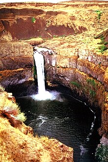
The most striking example of diluvial-evoirous "gigantic cauldrons" is still the waterbaths of the Channel Scablands (Fig. 1, 2).
Dilyuvial accumulation
The results of the accumulative activity of diluvial flows are of the greatest interest, since they are mainly amenable to unambiguous geological and morphological diagnostics, are well defined in the field and are decrypted in aerial and satellite images . They can also serve as a tool for calculating the hydraulic parameters of diluvial flows. The most informative in paleohydrological terms of the currently studied are diluvial-accumulative shafts and terraces (bars), as well as giant signs of ripple current (diluvial ridges, dunes and antidunes). Of particular interest are diluvial berm , studied, however, so far not enough.
The study of all issues related to the glacioclimatic and geological aspects of the formation of mountain and plain scablands is carried out in a wide framework of a new area of scientific research - Quaternary glaciohydrology , as a special section of general glaciology and geomorphology .
Illustrations
Fig. 5. The camp of geologists at the eastern front of the field of "curly rocks" of the Chagan scabland, the river basin. Chagan-Uzun, Southeast Altai
Fig. 6. "Dry waterfalls" of the Chagan scabland, river basin Chagan-Uzun, Southeast Altai
Fig. 7. Modern giant ripple signs at the end of the Alaskan Glacier Alsek. Photo by S. S. Chernomorets
Fig. 8. American geologist Keenan Lee studies lake-glacial sediments of the Chagan section, Chagan scabland, Southeast Altai
Fig. 9. Petroglyphs on the exhibited surface of the “curly rocks” of the Chagan scabland, Southeast Altai. Two directions of glacial hatching are clearly visible.
Fig. 11. Putorana Plateau , an extensive Quaternary scabland, one of the least visited and studied territories of the Asian part of the Russian Federation.
Notes
- ↑ Rudoi A.N. Geomorphological effect and hydraulics of the Late Pleistocene yocullaups of glacial-dammed lakes in Southern Siberia // Geomorphology, 1995. - Issue. 4. - S. 61-76.
- ↑ Groswald M.G. Eurasian hydrosphere catastrophes and glaciation of the Arctic. - M.: Scientific World, 1999. - 120 p.
- ↑ Bretz JH The Channeled Scabland of the Columbia Plateau // Geol. Soc. Am. Bull., 1923. - Vol. 31. - No. 3. - P. 617-649.
- ↑ V. M. Kotlyakov. Elsevier's dictionary of geography: in English, Russian, French, Spanish and ...
- ↑ Chernomorets SS, Rudoy AN Giant ripples as a result of large lake outbursts: distribution of the phenomena in mountainous areas of the world // Mitigation of natural hazards in mountain areas. Materials of International Conference, Kyrgyz Republic, Bishkek city, September 15-18, 2009 / Head edit. TV Tuzova. Bishkek: Salam, 2009.P. 24-26.
- ↑ Rudoy AN Earth analogues of the channels on Mars / The 30th Int. Microsymp. on comparative Planetology. - Moskow, Oktober 8-9, 1999.
- ↑ Marchenko A. G. The problem of the formation of fluvial relief on Mars // Bulletin of the Moscow University. Ser. geographer, 1993. - No. 4. - S. 87-91.
- ↑ Rudoi A.N. Geomorphological effect and hydraulics of the Late Pleistocene yocullaups of glacial-dammed lakes in Southern Siberia // Geomorphology, 1995. - Issue. 4. - S. 61-76.
- ↑ Grosvald M.G. Glaciation and volcanism of the Sayan-Tuva upland // Izv. RAS. Ser. geographer., 2003. - No. 2. - S. 83-92.
- ↑ Rudoi A.N., Baker V.R. Paleogyrology of the skeblend of Central Asia // Materials of glaciological studies, 1996. - Issue. 80. - S. 30-41.
- ↑ Rudoy A.N., Kiryanova M.R. Lake-glacial dammed formation and Quaternary paleogeography of Altai // Bulletin of the Russian Geographical Society, 1994. - V. 126. - Issue. 6. - S. 62-71.
- ↑ Rusanov G. G. Lakes and paleogeography of the Northern Altai in the Late Neopleistocene and Holocene. - Biysk: BSPU, 2007 .-- 164 p.
- ↑ Rudoi A.N. Geological work of Quaternary glacial superfluids. Forms of diluvial erosion and euphoria // Bulletin of the Russian Geographical Society, 2001. V. 133. Issue. 4.P. 31-40.
Literature
- Bretz JH The Channeled Scabland of the Columbia Plateau // Geol. Soc. Am. Bull., 1923. Vol. 31. No. 3. P. 617-649.
- Pardee JT Unusual currents in glacial Lake Missoula, Montana // Geol. Soc. Am. Bull., 1942. Vol. 53.1569-1600.
- Baker VR, Nummedal D. The Channeled Scabland . - NASA. Wash., DS, 1978. 186 p.
- Rudoi A.N., Baker V.R. Paleogyrology of the Central Asian skeblend // Materials of glaciological studies, 1996. Issue. 80.S. 30-41.
- Chernomorets SS, Rudoy AN Giant ripples as a result of large lake outbursts: distribution of the phenomena in mountainous areas of the world // Mitigation of natural hazards in mountain areas. Materials of International Conference, Kyrgyz Republic, Bishkek city, September 15-18, 2009 / Head edit. TV Tuzova. Bishkek: Salam, 2009. P. 24-26.
- Marchenko A. G. The problem of the formation of fluvial relief on Mars // Bulletin of the Moscow University. Ser. geographer, 1993. No. 4. P. 87-91.
- Grosvald M.G. Glaciation and volcanism of the Sayan-Tuva upland // Izv. RAS. Ser. geographer., 2003. No. 2. P. 83-92.
- Rudoy AN Earth analogues of the channels on Mars / The 30th Int. Microsymp. on comparative Planetology. - Moskow, Oktober 8-9, 1999.
- Grosvald M.G., Rudoi A.N. Quaternary glacial-dammed lakes in the mountains of Siberia // Izv. RAS. Ser. geographer., 1996. Issue. 4, pp. 112-126.
- Goncharov S.V. The boundary of the last glaciation on the Middle Yenisei: position and age // Dokl. USSR Academy of Sciences, 1986. T. 290. No. 6. P. 1436-1439.
- Rudoi A.N. Giant ripple of the current (history of research, diagnostics, and paleogeographic significance) - Tomsk: TSPU, 2005. - 228 p.
- Rudoi, A.N. and Kiryanova, M.R., Lake-glacial dammed formation and Quaternary paleogeography of Altai, Izv. Russian Geographical Society., 1994. T. 126. Issue. 6. S. 62-71.
- Rudoy AN, Baker VR Sedimentary Effects of cataclysmic Late Pleistocene glacial Flooding, Altai Mountains, Siberia // Sedimentary Geology, 1993. Vol. 85. N 1-4. R. 53-62.
- Rusanov G.G. Lakes and paleogeography of the Northern Altai in the Late Neopleistocene and Holocene. - Biysk: BSPU, 2007.164 s.
- PAUL A. CARLING, I. PETER MARTINI, JUERGEN HERGET, ao Megaflood sedimentary valley fill: Altai Mountains, Siberia. - Megaflooding on Earth and Mars / Ed. Devon M. Burr, Paul A. Carling and Victor R. Baker. Published by Cambridge University Press, 2009. P. 247-268.
- Paul L. Weis and William L. Newman. The Channeled Scablands of Eastern Washington: The Geologic Story of the Spokane Flood US Geological Survey, 1976.
- Rudoi A.N., Zemtsov V.A. New results of modeling the hydraulic characteristics of diluvial flows from the Late Quaternary Chuisko-Kurai glacier-dammed lake
Links
- A.N. Rudoi . Scablands. Scabland: exotic landscapes . Climate, ice. water, landscapes. Date of treatment January 30, 2011. Archived on May 27, 2012.
- A.N. Rudoi . Giant current ripples: A Review (unrevealed . Climate, ice, water, landscapes. Date of treatment January 30, 2011. Archived on May 27, 2012.
- The Channeled Scablands of Eastern Washington United States Geological Survey
- Keenan Lee. The altai flood
- Keenan Lee. The missoula flood
- Richard John Huggett . Fundamentals of Geomorphology 2nd Edition (PP. 246-247, 241). Routledge Fundamentals of Physical Geography. - London: 2007. - 483 p.
- Chuya Flood Video
- Mistery of megaflood
- Scablands in google maps
- The end of the tongue and the Alsek River, Alaska