Bay of Chalera ( French Baie des Chaleurs , English Chaleur Bay , translated from French as “Warm Bay” ) - part of St. Lawrence Bay , which separates the Gaspe Peninsula ( Quebec ) from New Brunswick ( Canada ). Width - about 50 kilometers. The length is about 137 km. Opened in 1534 by Jacques Cartier . The bay is teeming with fish, especially salmon.
| Shaler Bay | |
|---|---|
| fr. Baie des Chaleurs Chaleur bay | |
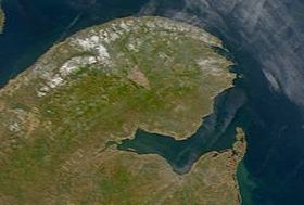 Shaler Bay. Photo taken from NASA satellite. | |
| Location | |
| Upstream water area | St. Lawrence Bay |
| A country |
|
| Provinces | Quebec , New Brunswick |
Title
The name was given by Jacques Cartier, who at one time saw fog over the bay and mistakenly concluded that the water in it was warm. Cartier sought the strait to Asia and named the southern tip of the Bay of Cap d'Espérance. He explored the bay on July 4–9, 1534 during his first expedition [1] .
The Micmacs called the Mowebaktabaak Bay the “Big Bay”.
Notes
- ↑ CARTIER, JACQUES (inaccessible link) . Dictionary of Canadian Biography Online. Date of treatment April 10, 2013. Archived May 27, 2012.