Onega Bay ( Onega Bay ) - the bay of the White Sea , located southwest of Arkhangelsk .
| Onega Bay | |
|---|---|
| Specifications | |
| Bay Type | Lip |
| Deepest | 36 m |
| Average depth | 16 m |
| Flowing rivers | Onega , Kem , Keret , Vyg |
| Location | |
| A country |
|
| Subjects of the Russian Federation | Republic of Karelia , Arkhangelsk Region |
| Areas | Belomorsky district , Onega district , Primorsky district |
Length 185 km, width 50-100 km, depth up to 36 m (average 16 m), stretched from southeast to northwest. The rivers flow: Onega , Kem , Vyg , Suma , Ukhta , Tapshenga , Kusherek , Tamitsa , Veiga , Unezhma , Nizhma , Rocheva , Nimenga , Kanda , Purnem , Lyamts . The height of the tides is up to 2.72 m, covered with ice for 185 days a year [1] .
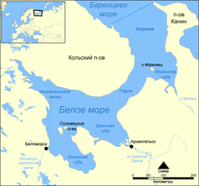
Numerous islands, most of them treeless, covered with tundra with dwarf birch . The largest and most famous archipelago of the bay is the Solovetsky Islands , where the Solovetsky Monastery is located. On the island of Kiy, near the mouth of Onega , the Onega Cross Monastery is located . Other large islands are Myagostrov , Shuyostrov , Kondostrov , Khedostrov , Kuzova archipelago in Kem skerries .
The bay is connected by the White Sea-Baltic Canal with the Baltic Sea . On the west coast, at the exit to the sea of the White Sea-Baltic Canal - the city of Belomorsk ; at the confluence of the Kem River - the city of Kem . At the southeastern end, at the confluence of the Onega River, is the city of Onega .
The southwestern coast of the bay, from Onega in the south to Kemi in the north, is called the Pomeranian coast ; the northeastern coast, from Cape Ukht-Navolok in the north to Onega in the south, is the Onega coast (this is the southwestern coast of the Onega Peninsula that separates the Onega Bay from the Dvina Bay ). The northwestern part of the Onega coast is sometimes called the Lyametsky coast , along the village of Lyamtsa .
Onega coast is characterized by terraced marshy plains and moraines with outcrops of crystalline rocks. Pomeranian coast is lower.
Protected from the north and northeast winds, the bay is characterized by a large number of clear, warm days. The coastal strip of the sea warms up well.
The salmon , herring and navaga are fished in the waters of the bay.
Content
Maps
- Sheets NQ 35-12 and NQ 35-12, NP 37-1, from a set of maps of Eastern Europe Cartographic military service of the USA . Series 501. 1954. Scale 1: 250,000
See also
- Malaya Sennukha - an island in the west of the bay
Notes
- ↑ Onega Bay - an article from the Great Soviet Encyclopedia .
Literature
- Encyclopedic Geographic Dictionary: Geographic Names / Ch. Ed. A. F. Treshnikov; Ed. col .: E. B. Alaev, P. M. Alampiev, A. G. Voronov and others. - M .: Sov. Encyclopedia, 1983.- S. 319.- 538 p. - 100,000 copies.
- Onega Bay // Small Encyclopedic Dictionary of Brockhaus and Efron : in 4 volumes - St. Petersburg. 1907-1909.