
Northern Canada ( eng. Northern Canada ) or the North ( eng. The North ) is the vast and northernmost region of Canada . From a political point of view, the term refers to the three territories of Canada : the Yukon , the Northwest Territories and Nunavutu . Also, the term North can be called the Canadian Arctic : part of the Canadian north of the Arctic Circle .
Territory
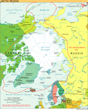
In 1925, Canada declared its rights to the territory of the Arctic between 60 ° W and 141 ° W [1] longitude , and to the north to the North Pole : all the islands in this area are the territory of Canada and its territorial waters. Recognition of territorial claims is complicated by disagreements in legislation. Canada and the USSR / Russia have long divided the Arctic by sector to the North Pole . The United States does not recognize division into sectors and has never claimed the territory of the Arctic archipelago of Alaska . Statements that the seabed is a continuation of the country's continental shelf are used to support territorial claims; for example, Denmark / Greenland claim territory to the North Pole, some of which are disputed by Canada. Foreign courts, military and civilian, are granted the right of innocent passage through the territorial waters of a coastal state in accordance with the UN Convention on the Law of the Sea [2] . However, the right of innocent passage is not permitted in inland waters, which are enclosed bodies of water or coastal waters with a string of islands. Disagreements over sectoral separation or extension of the territory to the North Pole and the definition of inland waters in the Arctic determine disagreements over territorial disputes in the Arctic. These requirements are recognized by almost all countries, including the United States of America; Denmark, Russia and Norway claim similar rights to the Arctic territories, which is met with resistance from the European Union and the United States.
This is especially important in the situation with the Northwest Passage . The Canadian government claims that the passage enters the Canadian inland waters because it is only 20 kilometers from the islands of the Canadian Arctic Archipelago ; The USA declares that it is international waters . At present, ice and low temperatures make this issue irrelevant, but global warming can make the passage suitable for navigation and adversely affect the ecology of this area, which worries the Government of Canada.
Exactly the same disputes (with Denmark) are conducted over the island of Hans , in the Nares Strait west of Greenland, which may threaten the sovereignty of Canada in the Arctic.
Geography
While most of the Arctic is a territory of permafrost and tundra, it is surrounded by different geological areas: the Innuit Mountains , which are connected to the Arctic Cordillera mountain system, which is geologically different from the Arctic areas (mainly consisting of lowlands). The arctic lowland and lowland of the Hudson Bay include the bulk of the geographic region, often seen as part of the Canadian shield (in contrast to the sole geological area). The soil mainly consists of permafrost, which makes construction difficult and often dangerous occupation, agriculture is almost impossible.
The Arctic watershed diverts water from northern regions of Manitoba , Alberta , British Columbia , from most of the Northwest Territories and Nunavut, as well as from some areas of the Yukon to the Arctic Ocean, including the Beaufort Sea and Baffin Sea . Apart from the Mackenzie River , the longest river in Canada, this watershed was almost never used for hydropower . Key sites in the watershed are the Peace River and the Athabasca , as well as the Great Bear and the Great Slave (the two largest lakes in Canada). Each of these lakes connects with the Mackenzie River, thus collecting most of the water flow from the Arctic watershed.
Demographics
The region is sparsely populated. As of 2006, the population is only 101,310 people [3] who lived in an area larger than Western Europe . The territory is rich in mineral resources, but in most cases their mining is unprofitable and dangerous for the environment. Although the percentage of GDP per capita is larger than anywhere else in Canada, the region remains relatively poor, mainly due to the high cost of living and prices for consumer goods, therefore the region is quite heavily subsidized by the Government of Canada . About 51% of the population of the three territories are Indians , Inuit , First Nations or Metis . [4] Inuit are the largest indigenous group in Northern Canada, 59% of all Canadian Inuit live here, and their share in Nunavut is 50%. [4] Several groups of Indians also reside in the region, mainly from the Chipewyan ethnic group . There are more indigenous people in each of the three territories than anywhere else in Canada. There are also many later immigrants from all over the world; of all the territory, the Yukon has the largest percentage of historically unconnected residents. [five]
Current State
For hundreds of years, this territory has been considered the largest “wild” area in the world. However, over the past 20 years (and especially the last 5), this area has experienced an economic boom along with other Canadian provinces. In some cities, there has been a slight increase in population, which has not been the case for several decades. Yellowknife became the center of the diamond industry in Canada (the country ranked third in the world in diamond production). Another new phenomenon for the north appeared in the city - the city silhouette and skyscrapers.
Also, as a result of the diamond boom, the average per capita income is $ 95,000.
According to the results of the Canadian population census for 2006 , for the first time in Canadian history, just over 100,000 people lived in three territories. [3]
See also
- Arctic Circle
- Tree line
- Geography of Canada
- Regions of Canada
- Provinces and territories of Canada
- Canadian Arctic Archipelago
- British Arctic Territories
- Operation Hurricane (Canada)
- Nord-du-Québec
Sources
- ↑ The Atlas of Canada - Territorial Evolution, 1927 Archived May 9, 2012.
- United Nations Convention on the Law of the Sea
- 2 1 2 Population and dwelling counts, for Canada and 2006, 2001 censuses - 100% data
- ↑ 1 2 2001 Census Aboriginal Population Profiles
- ↑ Aboriginal Identity Population, Percentage Distribution, for Canada, Provinces and Territories - 20% Sample Data from the 2001 Census