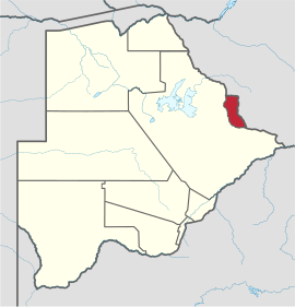
The North-East District [2] ( eng. North-East District ) - District [3] in Botswana . The administrative center is the city of Masunga ( en: Masunga ).
| County | |
| Northeast District | |
|---|---|
| English North-east district | |
| A country | Botswana |
| Includes | 2 sub- districts : Francistown and Northeast |
| Adm. Centre | Masunga |
| History and Geography | |
| Square | 5 120 km² (8th place ) |
| Timezone | UTC + 2 |
| Population | |
| Population | 159,225 [1] people people ( 2011 ) ( 6th place ) |
| Density | 31.1 people / km² (2nd place) |
| Nationalities | galanga |
| Denominations | Christianity , animism |
| Official language | English , Tswana |
| Digital identifiers | |
| ISO 3166-2 Code | BW-NE |
 | |
Content
Geography
Neighboring areas:
- Central - in the West
- Southern Matabeleland ( Zimbabwe ) - East
Settlements
The largest:
- Francistown / en: Francistown , 113,315 - Botswana's 2nd most populated city
- Masunga / en: Masunga , 3,175
Villages:
- Botalaot 173
- Bataille 549 [4]
other
Administrative Division
Administratively, the district is divided into 2 sub-districts: Francistown and Northeast .
Economics
Gold ore is being mined . Francistown has an international airport. The railway from Plumtri ( South Matabeleland ) to Palapye ( Central District ) passes through the territory of the okrug.
References and Sources
- A biography of Tshekedi Khama 1905-1959
- Atlas of the world. GNPP Cartography . 2005 year
- Botswana. Moscow, 1985 Authors: Volkov V.V., Chirkov V.S.
Notes
- ↑ The population of Botswana . City Population. Date of treatment August 22, 2014. Archived on August 22, 2014.
- ↑ Botswana. Reference map (scale 1: 1 750 000). - GUGK, 1977
- ↑ Botswana. Geographical name indicator (on the back of the map). - GUGK, 1977
- ↑ [ http://www.cso.gov.bw/media/2011%20Census%20_Alphabetical%20Index%20_Population%20of%20Villages.pdf 2011 Botswana Population and Housing Census. Alphabetical Index of Villages] (inaccessible link - history ) .