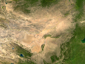
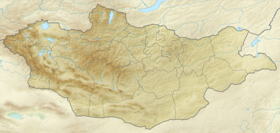
The Mongolian plateau is a vast plateau in the east of Central Asia with dimensions of about 2500 per 700 km. It covers an area of about 2.6 million km² [1] (including the Chinese part of about 1.4 million km² [2] ). Divided by the Gobi Desert into two parts - the northern part is located in Mongolia , and the southern - in the Chinese autonomous region of Inner Mongolia .
| Mongolian plateau | |
|---|---|
| mong. Mongolyn Hawtgay | |
 Gobi Desert and Mongolian Plateau | |
| Specifications | |
| Absolute height | 915-1525 m |
| Location | |
| Country |
|


Geography
The mountains of Altai , Tannu-Ola and Sayan mountains border the plateau from the north-west, the Khentei Plateau from the north, the Bolshoi Khingan Range , from the south the Tarim Basin , and from the west the Jungar basins of the Xinjiang Uygur Autonomous Region .
The height of the plateau varies from 915 to 1525 m. To the east and south of Ulan Bator towards the border with China, the height of the Mongolian plateau gradually decreases. The highest point - Mount Munkh-Khayrhan-Ula (4362 m) [1] - is located in the ridge of the Mongolian Altai . The Gobi Altai Range stretches along the western part of the plateau.
The dry continental climate of the Mongolian plateau causes a small amount of precipitation - 200 mm per year. Temperature varies widely. In Ulan Bator, for example, the average January temperature is −26 ° C, and July - +17 ° C. [one]
The rivers Selenga and Kerulen flow along the plateau. In the Chinese part of the plateau alone, there are more than 220 salt lakes. [2]
Population and Economics
The northern regions of the plateau are inhabited mainly by the Mongols , in the west - by the Kazakhs . The population of Inner Mongolia at 4/5 consists of the Chinese ( Han ). The plateau lands are relatively poorly developed economically.
The plateau is a dry steppe overgrown with short grass; nomadic cattle breeding is developed (sheep, goats, cows, horses and camels). Agriculture is limited by climatic conditions; Wheat , oats and other cereals and vegetables are grown. Sugar beets and oilseeds are cultivated in the irrigated areas of Inner Mongolia. Coal is mined on the Mongolian part of the plateau ( Sain-Shan ), coal and iron ore ( Baotou ) are mined on the Chinese. In addition, there is copper , molybdenum , fluorspar , uranium , gold , silver and other minerals. [one]
Completed in 1955 [1], the Trans-Mongolian Railway connects Ulan Bator, located in the north of the plateau, with the Russian city of Ulan-Ude and the Chinese Eren-Hot .
Notes
- ↑ 1 2 3 4 5 Mongolian Plateau (English) . - article from Encyclopædia Britannica Online . Date of treatment January 8, 2010.
- ↑ 1 2 Zheng Xiyu. Salt lakes on the Inner Mongolian Plateau of China // CHINESE GEOGRAPHICAL SCIENCE. - Science Press, Beijing, China, 1991. - T. 1 , no. 1 . - S. 83--94 .
See also
- Geography of china
- Geography of Mongolia