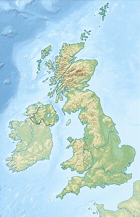
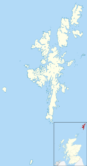
Yell , Yell is an island in the north of the Shetland Islands , Scotland .
| Yell | |
|---|---|
| English Yell | |
 | |
| Specifications | |
| Square | 212 km² |
| Highest point | 210 m |
| Population | 957 people (2001) |
| Population density | 4.51 people / km² |
| Location | |
| Archipelago | Shetland islands |
| Washer water areas | Atlantic Ocean , North Sea |
| A country |
|
| Region | Scotland |
| Area | Shetland |
Content
Geography
It covers an area of 212 km², making it the second largest in the archipelago and the eleventh in Scotland. It is washed in the southeast by the North Sea, in the northwest by the Atlantic Ocean. According to the 2001 census, 957 inhabitants live on the island, with an average population density of 4.5 inhabitants per km². It is the fifteenth most populated island of Scotland , and the third in the group of Shetland Islands, after Mainland and Walsey . The highest point is Mount Erisdale, 210 meters above sea level.
The island in particular and the Shetland Islands as a whole are the border between the northern part of the North Sea in the east and the Atlantic in the west. The 1st meridian of west longitude passes through the eastern part of the island.
Yell stretched in the meridional direction for 31 kilometers, with a maximum width of 12 kilometers. In the northeast, Yell is separated by the narrow Blumall Sound Strait from Anst Island, and in the southwest by Yell Strait from Mainland . The eastern coast of the island, as a rule, is low and sandy, while the western coast is rocky, rising to a height of 60-120 meters. The island is cut by several bays forming a natural harbor. There are also a number of sand spits connecting the peninsula with the main part of the island. Many of them are very short-lived and can be easily damaged by erosion caused by human activity, or severe storms, creating new islands or reviving old ones. There are few cultivated lands on the island, but coastal waters are rich in fish.
Most of the interior of the island is covered with a peat layer three meters thick, which is the result of sediments lasting three millennia. Peat is capable of holding large amounts of water, but it is highly susceptible to erosion, especially near the coast.
Yell Island is surrounded by small islands: Bigga , Stupid Hill , Yeri Lingi , Linga , Lamba , Little Roe , Little Hill , Mackle Hill , Orfacey , Brother Island , Sound Gruney , Ern Rock , Uyea , Fish Hill , Haaf-Grunei , Haskosei , Yunari and indented by small bays, bays: Barra , Basta , Mid-Yell , Otters .
Settlements: Basta , Burravo , Gutcher , Silly , Kallyvo , Kopister , Mid-Yell , Otterswick , Ulst , West Sandwich , Eyewick .
Wildlife
There is an otter on the island, a large and short-tailed skuas . In the Otterswick and Graveland Wildlife Refuge under the protection of the Red-throated Loon (Gavia stellata) - 27 pairs, 2.9% of the UK population [1] .
History
Yell has been inhabited since the Neolithic. Several broch type structures were identified and assigned to the Donorwegian period. Norwegian rule continued from the 9th to the 14th century, after which the island came under the control of Scotland.
Economics
Yell is connected by the Shetland Islands Council Ferries , with Anst , Mainland and Fetlar Islands. Ferries depart for the village of Gutcher in the northeast of the island to Belmont village in the southwest of Anst Island and Cape Hamars Ness in the northwestern part of Fetlar Island. In the village of Ulst in the south-west of the island, there is a ferry service to the village of Toft in the north of the island of Mainland [2] . There are marinas in the villages of Barravo , Kallyvo , Mid Yell .
The A968 motorway crosses the island from southwest to northeast and connects with the islands of Anst and Mainland via ferry crossings. The B9081 road, starting in the village of Mid Yell along the east and south coast of the island, leads to the village of Ulsta . The road "B9082" connects the villages of Gutcher and Kallivo . "B9083" - the villages of Kallivo and Stupid .
Politics and Power
The island is governed by a council of Yell Island, consisting of nine deputies elected in three constituencies [3] .
The Mid Yell Police Station provides law enforcement on the island [4] .
The fire and rescue station in the village of Ulsta in the south of the island is called Mid Yell. Twelve station employees deal with emergencies, including fires and traffic accidents [5] .
Education
The island has primary schools “Burravoe Primary School” in Barravo [6] and “Cullivoe Primary School” in Kallyvo [7] , and the secondary school “Mid Yell Junior High School” in Mid Yell [8] .
Attractions
- Manor " North Haa " XVII century built. In 1971, the estate and the surrounding buildings were included in the list of architectural monuments of category “A” [9] .
- The Old Haa Museum of Local History operates in the village of Barravo in the southeastern part of the island. The museum building was built in 1672 . In 1971 it was included in the list of architectural monuments of category “B” [10] .
Famous residents
- Pirie Willie Johnson (1920-2007) - musician, guitarist [11] .
- Jake Leslie Davis “ Topiary ” is one of the participants in the hacker attacks “ Operation AntiSec ” and “ LulzSec ” [12] .
- Robert Nisbet (1834–1917) - sailor and public figure, captain of sea vessels.
- Bobby Talloch (1929-1996) - scientist [13] .
See also
- List of islands in Scotland
- List of Shetland Islands
Notes
- ↑ Otterswick and Graveland Wildlife Refuge
- ↑ Ferries.
- ↑ Yell Island Council
- ↑ Police Station
- ↑ Fire and Rescue Station. (inaccessible link) . Archived on September 28, 2013.
- ↑ Burravoe Primary School Primary School
- ↑ Cullivoe Primary School Primary School
- ↑ Mid Yell Junior High School High School
- ↑ North Haa Manor
- ↑ Monument of architecture of category “B”
- ↑ Biography
- ↑ Hacker article
- ↑ Bobby Talloch
Links
- Jell Island Council
- Ell // Brockhaus and Efron Encyclopedic Dictionary : in 86 volumes (82 volumes and 4 additional). - SPb. , 1890-1907.
- Yell // Encyclopedic Dictionary of Brockhaus and Efron : in 86 volumes (82 volumes and 4 additional). - SPb. , 1890-1907.