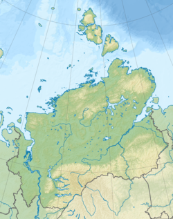
Norilskaya [2] ( Norilka [3] , in the upper Talaya [4] [5] ) is a river in the north of the Krasnoyarsk Territory of Russia , which flows territorially through the Taimyr Dolgan-Nenetsky District . The length is 57 [4] km. The average water consumption is 450 [3] m³ / s.
| Norilsk | |
|---|---|
 Falling into the Norilsk Falling into the Norilsk its right tributary - p. Outrigger | |
| Characteristic | |
| Length | 57 km |
| Pool | 20,000 km² |
| Water flow | 450 m³ / s |
| Watercourse | |
| Source | Small |
| • Height | 44 m |
| • Coordinates | |
| Mouth | Pyasino |
| • Height | 28 m |
| • Coordinates | |
| Location | |
| Water system | Pyasino → Pyasina → Kara Sea |
| A country |
|
| Region | Krasnoyarsk region |
| Area | Taimyr Dolgan-Nenets District |
| HWR Code | |
7 km to the northeast of the city of Norilsk , the village of Valek is located on the river. It flows from the lake Melkogo [5] .
The main tributaries are the Rybnaya and Valek rivers. In the summer, the Norilka River is navigable, used for tourism, fishing and water transport.
The height of the source is 44 m above sea level [6] . The mouth height is 28 m above sea level [6] .
The bridge over the Norilka is noted in the UNESCO collection “The Bridge Construction of the World ” as “the northernmost of the large bridges in the world behind the 69th parallel”.
Content
Basic Information
The length of the river is 57 km, the basin area is about 20 thousand. [4] km². It flows through the North-Siberian lowland . The average annual water discharge at the mouth is 460 m³ / s. [3] It flows out of Lake Melkoye , flows into Lake Pyasino with the formation of a delta . Geomorphologically, the Norilsk River can be considered the upper course of the Pyasina River .
River hydrology
The Norilka River basin is located above the Arctic Circle , in the climatic zone of the tundra and forest-tundra , a common permafrost . Mixed river feeding - snow and rain. High water from June to August. It freezes at the end of September and opens in the middle of June.
The hydrological regime of the river is determined by the extremely northern location of the river basin with a short summer period of positive temperatures; the flat character of the river with a small fall of the channel; heavy rainfall throughout the year and the presence of large lakes within the catchment. The Melkoye , Lam , Ketha , Glubokoye , Sobachye , Nakomyaken lakes and numerous small lakes in the tundra play a regulating role in the water regime of the river, smoothing floods. [3] [7]
Economic value
On the river is located the village of Valek , the buildings of the former dispensary , the airport of local airlines Valek and the combined rail-road bridge that connects Norilsk and Talnakh . Prior to the construction of the bridge, transport links between Norilsk and Talnakh were carried out: in the summer - Through the ferry and pontoon bridge, in the winter - Through the ice crossing.
The airport has a runway of 650 × 28 m for receiving An-3 , An-2 aircraft and lower class, and helicopters of all types. Previously, the river was used to receive the seaplanes of the Norilsk Combine . For this reason, the airport is traditionally called a hydroport . [8] [9]
The river is inhabited by arctic species of fish and it is actively used for fishing. In the summer period from the end of June to September, Norilsk is navigable and is used for recreational purposes and for water tourism to the Lakes Pyasino , Melkoye and to the large lakes on the Putorana Plateau - Lama , Glubokoe , Sobachye , Nakomyaken and Ketha . [ten]
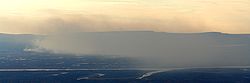
Proximity to the Norilsk Combine leads to environmental pollution of the river and Lake Pyasino.
Notes
- ↑ Surface water resources of the USSR: Hydrological knowledge. T. 16. Angaro-Yenisei district. Issue 1. Yenisei / ed. G.S. Karabaev. - L .: Gidrometeoizdat, 1967. - 823 p.
- ↑ Norilsk // Dictionary of names of hydrographic objects in Russia and other CIS countries / ed. G. I. Donidze. - M .: Kartgeocenter - Geodesizdat, 1999. - P. 323. - ISBN 5-86066-017-0 .
- ↑ 1 2 3 4 5 Norilka At Valek , R-Arcticnet V4.0
- ↑ 1 2 3 State Water Register . River Norilka (Talaya, Norilsk) . textual.ru . Ministry of Environment of Russia (March 29, 2009). The appeal date was December 20, 2018. Archived March 29, 2009.
- ↑ 1 2 Great Soviet Encyclopedia // B.A. Vvedensky II. - Moscow: Freight One named after Molotova, 12/03/1954 g. - T. 30 , no. NIKOLAEV - OLONKS . - p . 637 .
- ↑ 1 2 Sheet of map R-45-XXIII, XXIV Norilsk . Scale: 1: 200 000. Specify the date of issue / state of the area .
- ↑ Norilka at Valek Unsolved (inaccessible link) . Archived November 24, 2009. , UNESCO: Water resources
- ↑ Photos of Norilsk. Alexander Ananiev , Norilsk Chronicles, photos
- ↑ Urvantsev, N. N. Yenisei - the industrial gate of Siberia // Taimyr - my northern region . - M .: Thought, 1978. - S. 29. - 238 p.
- ↑ Putorana Plateau July 25 - August 20, 1996, Chronic Vodnik Club