Vilyui Reservoir - a reservoir formed by the Vilyui Hydroelectric Power Station in Russia on the Vilyui River , a tributary of the Lena River. Geographically located in Yakutia near the republican border with the Irkutsk region , about 80 km east of the Lower Tunguska River , the right tributary of the Yenisei . [2] The surface area is 2360 [1] km². The catchment area is 141 150 km² [1] .
| Vilyui reservoir | |
|---|---|
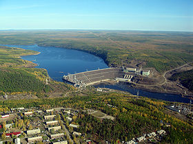 Vilyui hydroelectric station and village Chernyshevsky. | |
| Morphometry | |
| Height above sea level | 231 - 249 [1] m |
| Dimensions | 470 × 18 km |
| Area | 2360 km² |
| Volume | 40.4 km³ |
| Deepest | 70 m |
| Average depth | 17 m |
| Swimming pool | |
| Pool area | 141 150 km² |
| Flowing watercourses | Vilyuy , Chona |
| Flowing watercourse | Vilyuy |
| Location | |
| A country |
|
| The subject of the Russian Federation | Yakutia |


Content
- 1 Basic Information
- 2 Economic value
- 3 notes
- 4 References
Basic Information
The reservoir was formed in 1965 - 67 years. dam Vilyui hydropower plant on the river Vilyui . When the reservoir was created, 2.3 thousand hectares of farmland were flooded and 50 buildings were relocated. [one]
The area of the reservoir at a height of 246 m above sea level is 2,360 km² . According to the hydropower plant project, it is permissible to raise the level to a forced retaining level of 249 m and operate it to 231 m, which corresponds to a maximum amplitude of 18 m. [1] Significant changes in the water level are caused primarily by the uneven precipitation in different years.
The average long-term inflow of water is 20 km³ per year. The total volume of the reservoir at NPU is 40.4 km³, including the useful one - 22.4 km³. [one]
Economic Significance
The reservoir is used for seasonal and multi-year regulation of Vilyuya runoff, as well as for water supply, shipping and fishing. Fish live here - nelma , chir , etc. [3] [4] The passes from the reservoir through the spillway of a hydroelectric power station are used to provide navigation conditions in the lower reaches of the Vilyui River. [5] [6]
Notes
- ↑ 1 2 3 4 5 6 Hydro units on the river Vilyuy (inaccessible link - history ) . www.lhp.rushydro.ru . , JSC RusHydro , Lenhydroproject
- ↑ See the article on the project to create a hydroelectric power station - the Evenki Hydroelectric Power Station - on the Lower Tunguska River .
- ↑ Dictionary of modern geographical names / Rus. geo about . Mosk. center; Under the total. ed. Acad. V.M. Kotlyakova . Institute of Geography RAS . - Yekaterinburg: U-Factoria, 2006.
- ↑ Vilyui Reservoir // Great Soviet Encyclopedia : [in 30 vol.] / Ch. ed. A.M. Prokhorov . - 3rd ed. - M .: Soviet Encyclopedia, 1969-1978.
- ↑ Vilyui waterworks: socio-environmental consequences . www.plotina.net . Date of treatment December 18, 2018.
- ↑ Dam. No! . www.plotina.net . Date of treatment December 18, 2018.
Links
- Vilyui reservoir (physical map, scale 1: 1 000 000) // National Atlas of Russia . - M .: Roskartografiya, 2004. - T. 1. - S. 251. - 496 p. - 3000 copies. - ISBN 5-85120-217-3 .
- Photoalbum: Yakutia, Vilyui reservoir. . bayanac.narod.ru . Date of treatment December 18, 2018.