Kaiserstuhl (German Kaiserstuhl ) is a plateau of volcanic origin in the south-west of Germany , in the state of Baden-Württemberg .
| Kaiserstuhl | |
|---|---|
| him. Kaiserstuhl | |
 | |
| Highest point | |
| Absolute height | |
| Location | |
| A country |
|
History and Geography
The Kaiserstuhl up to 557 meters high belongs to the geographic region of the Upper Rhine Lowland , in southern Baden , east of the Rhine , in a northwest direction from the city of Freiburg . The average height of the highlands is 355 meters. The highest heights are reached by the Totenkopf mountains (height 557 meters), Eichelspitze (height 520 meters), Katarinenberg (height 492 meters). The length of Kaiserstuhl from southwest to northeast is 16 kilometers, its greatest width is 12.5 kilometers.
The name ( Kaiserstuhl - in the translation of the Emperor’s Throne ) was given to the highlands in memory of the German King (later - the emperor) Otton III , who ruled here at the very end of the 10th century. Kaiserstuhl was first mentioned in writing in 1304 .
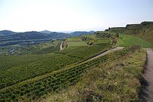
According to geology, volcanic activity in this area occurred in the Tertiary period . The mountain range is rich in rare minerals: wollastonite , various zeolites , and garnet are found here. Climatically, Kaiserstuhl belongs to the warmest regions of Germany. Here, as in the Mediterranean, mild winters are observed followed by hot summers. Thanks to the loessial rocks covering the volcanic sole, conditions for viticulture are very favorable in Kaiserstuhl. A significant number of thermophilic animals also live here. In Kaiserstuhl, Germany's largest population of May beetles (in other regions almost extinct), is preserved.
Cities of the region
The following cities are located in the Kaiserstuhl district:
- Eichstetten
- Balingen
- Bötzingen
- Breisach am Rhein
- Ambush
- Ihringen
- Crossbar
- Vogtsburg
- Endingen