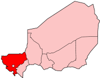
Tillabéri ( French: Tillabéri ) is a region in Niger . Its area is 97 251 km². The population is 2,572,125 people (as of 2011 ). The population density is 26.45 people / km². The administrative center of the region is the city of Tillabury .
| Region (province) | |
| Tillabury | |
|---|---|
| fr. Tillabéri | |
| A country | Niger |
| Includes | 6 departments |
| Adm. Centre | Tillabury |
| History and Geography | |
| Square | 97 251 km² (5th place ) |
| Timezone | UTC + 1 |
| Population | |
| Population | 2 572 125 [1] people ( 2011 ) ( 4th place ) |
| Density | 26.45 people / km² (4th place) |
| Digital identifiers | |
| ISO 3166-2 Code | NE-6 |
 | |
On the territory of Tillaberi is the capital of the country Niamey , allocated in a special administrative unit.
Content
Geography
The Tillaberi region is located in the southwest of Niger. To the north of it lies the state border of Niger with Mali , to the west of it is the state border with Burkina Faso , in the south-west is the state border with Benin . To the east of Tillaberi lies the Nigerian province of Tahua , to the southeast - the province of Doso .
The Niger River and its tributaries Gorvol , In-Ates , Sirba flow through the province of Tillaberi.
Administrative Division
Administratively, the region is divided into 6 departments and 1 municipality (the city of Tillaberi). [2]
Department of Filingu (Filingué):
- Area: 26,217 km²
- Population: 553,127 (2011)
Department of Kollo :
- Area: 10,002 km²
- Population: 443,371 (2011)
Department of Wallam (Ouallam):
- Area: 22,093 km²
- Population: 383,632 (2011)
Department of Say:
- Area: 14,430 km²
- Population: 316,439 (2011)
Department of Tera :
- Area: 15,794 km²
- Population: 579,658 (2011)
Tillabéri Department :
- Area: 8715 km²
- Population: 295,898 (2011)
Notes
- ↑ Institut National de la Statistique du Niger: Le Niger en chiffres 2011 , p.23
- ↑ Institut National de la Statistique du Niger: Annuaire statistique des cinquante ans d'indépendance du Niger , P ..