Malinovka (until 1948 - Lenka-Kabazi ; Ukrainian, Malinivka , Crimean-Tat. Qobazı, Kyobazy ) - a village in the Bakhchisarai district of the Republic of Crimea , as part of the Postal settlement (according to the administrative-territorial division of Ukraine - the Postal Council of the Autonomous Republic of Crimea ), previously was one of the branches of the farm to them. Chkalova . In Malinovka there are 6 streets and 1 lane [7] , the area occupied by the village is 15 hectares, in which, in 116 yards, according to the Village Council for 2009, there were 367 inhabitants [8]
| Village | |
| Robin | |
|---|---|
| Ukrainian Malinivka , Crimean-Tat. Qobazı | |
 | |
| A country | Russia / Ukraine [1] |
| Region | Republic of Crimea [2] / Autonomous Republic of Crimea [3] |
| Area | Bakhchisarai district |
| Community | Postal postal settlement [2] / Postal postal council [3] |
| History and Geography | |
| First mention | 1678 |
| Former names | until 1948 - Kobazy |
| Square | 0.15 km² |
| Center height | 207 m |
| Timezone | UTC + 3 |
| Population | |
| Population | ↗ 336 [4] people ( 2014 ) |
| Official language | Crimean Tatar , Ukrainian , Russian |
| Digital identifiers | |
| Telephone code | +7 36554 [5] |
| Postcode | 298426 [6] / 98426 |
| OKATO Code | |
| OKTMO Code | 35604402121 |
| COATUU code | 120455604 |
Population
| Population | |
|---|---|
| 2001 [9] | 2014 [4] |
| 309 | ↗ 336 |
The 2001 All-Ukrainian Census showed the following distribution by native speakers [10] :
| Tongue | The number of inhabitants. | Percent |
|---|---|---|
| Russian | 191 | 61.81 |
| Crimean Tatar | 95 | 30.74 |
| Ukrainian | nineteen | 6.15 |
Population Dynamics
|
|
Geography
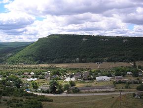
Robin is the most northeastern village of the region, located on the right bank of the Alma valley , in a kind of canyon, at the river’s outlet from the Inner ridge of the Crimean Mountains , the height of the village center above sea level is 207 m [22] . The distance to Simferopol is 17 km [23] , to Bakhchisarai - about 19 kilometers [24] . Transport communication is carried out along the regional highway 35Н-062 [25] (according to the Ukrainian classification - С-0-10224 [26] ) from the highway 35Р-001 (Simferopol - Sevastopol). 2 km from the village there is a 1479 kilometer railway platform, through which trains to Sevastopol and Simferopol follow.
Title
The etymology of the historical name of Robin - Kobaz is not exactly established. According to one version of Kobaza - an abridged version of the original name Koba-Agza, which means “cave hole” in the Crimean Tatar ( qoba - cave, ağız - mouth, mouth, opening, hole). The variant of the name Lenka-Kabazi [27] cited in the decree of the Presidium of the Supreme Council of the RSFSR of May 18, 1948 on renaming and mentioned in all post-war literature comes from the name of Lenin Kabazi , found, for example, on a 1936 map [28] .
History
There is little evidence of the existence of Kobazy during the time of the Crimean Khanate : for the first time, in the documents that have reached, he was found in the kadiaskerké defter (court case) of 1678 [29] , in the same cases of the 17th – 18th centuries the village’s jamaat [30] was mentioned, acting as an independent legal faces [29] . Compiled in 1784, just before the annexation of Crimea , the “Cameral Description of the Crimea” in the Bakhchisarai Kadylik of the Bakhchisaray Kaymakanism recorded two villages: Kobazy and Other Kobazy [31] - parishes-maale of a large village [32] .
After the annexation of Crimea to Russia (April 8, 19 April 1783 [33] , (8) February 19, 1784, by the registered decree of Catherine II to the Senate , in the territory of the former Crimean Khanate the Tauride Region was formed and the village was assigned to Simferopol Uyezd [34] . After the Pavlovsk reforms, from 1796 to 1802, it was part of the Akmechet district of Novorossiysk province [35] . According to the new administrative division, after the creation of the Tauride province on October 8 (20), 1802 [36] , it was part of the Aktachin volost of Simferopol district.
According to the Vedomosti, about all villages in Simferopol Uyezd consisting of an indication in which the volost is the number of yards and souls ... dated October 9, 1805, 263 Crimean Tatars lived in 44 yards in Kobazy and the land belonged to the provincial secretary Chernov, known in Crimean history [11] . On the military topographic map of Major General Mukhin of 1817, 25 yards in the village are indicated [37] . After the reform of the volost division of 1829, Kobazy, according to the Vedomosti on the official volosts of the Tauride province of 1829 , was assigned to the Yashlav volost (renamed from Aktachinsky) [38] . On the map of 1842, 35 yards are indicated in the village [39] .
In the 1860s, after the Zemstvo reform of Alexander II , the village was assigned to the Mangush volost . According to the “List of Populated Places of the Tauride Province” of 1864 , according to the results of the VIII revision , Kobazy is the owner’s Russian and Tatar village on the Alma River , with 24 courtyards, 110 inhabitants and a mosque [12] , and on the three-verst map of 1865-1876 there are 12 courtyards (on the map there is the neighboring village of Kur-Tymez , which is not in the "List ...") [40] . The village was empty, apparently due to the emigration of the Crimean Tatars to Turkey [41] , and migrant workers from Russia settled in the estate of the old village and already in 1872, Orthodox from Kobaz were mentioned among the parishioners of the Balta-Chokrak church [42] . For 1886, in the village of Kabaz , according to the reference book “Volosts and important villages of European Russia”, 97 people lived in 20 households, a mosque operated [13] . In the Memorial Book of the Tauride Province of 1889 (according to the results of the 10th revision of 1887), the village of Novye Kobazy with 12 yards and 86 inhabitants was not assigned to the volosts (new villages with a non-Muslim population usually fell into this category) [14] .
After the Zemstvo reform of the 1890s [43], the village was transferred to the new Tav-Bodrak volost . On a detailed map of 1890, on the site of the village, an unnamed landowner estate [44] (a certain landowner Klachanovsky [45] ) is shown. In 1912, already in the village of Kobazy, the construction of a new mekteba building was begun [46] . According to the Statistical Directory of the Tauride Province. Part II. Statistical essay, issue of the sixth Simferopol Uyezd, 1915 , in the village of Kabaz of the Tav-Bodrak volost of Simferopol Uyezd there were 19 yards with a Tatar population of 133 registered residents. In possession were 152 acres of convenient land and 15 acres of inconvenience, all holdings had land allotments. The farms had 36 horses, 19 cows, 25 calves and foals and 1290 heads of small livestock. There was also Zeisler’s estate “Kabaza” - 5 German yards, 7 ascribed and 14 “outsiders” residents of 600 acres of convenience and 200 inconvenience, 31 horses, 10 oxen and 11 cows [15] ..
After the establishment of Soviet power in Crimea, according to the decision of the Krymrevkom of January 8, 1921 [47] , the volost system was abolished and the village was included in the Podgorodne-Petrovsky district of Simferopol district, and in 1922 the districts were called districts [48] . On October 11, 1923, according to the decree of the All-Russian Central Executive Committee, the administrative division of the Crimean Autonomous Soviet Socialist Republic was amended, as a result of which the Podgorodne-Petrovsky district was liquidated and Simferopolsky and Kabazy were formed and included in its composition [49] . According to the List of settlements of the Crimean Autonomous Soviet Socialist Republic according to the All-Union Census on December 17, 1926 , in the village of Kabazy, Bazarchik village council of Simferopol region, there were 26 households, all peasant, the population was 116 people (51 men and 65 women). In the national relation, 73 Russians, 12 Ukrainians, 8 Germans, 9 Greeks, 11 Czechs, 1 Bulgarian, 2 are recorded in the “other” column [17] . According to the All-Union Census of 1939, 106 people lived in the village [18] . In 1940, the village, together with the village council, was already part of the Bakhchisarai district [50] .
In 1944, after the liberation of the Crimea from the Nazis, on August 12, 1944, Resolution No. GOKO-6372c “On the resettlement of collective farmers to the Crimea” was adopted, according to which it was planned to resettle 6000 collective farmers [51] and in September 1944 the first new settlers arrived in the district (2146 families) from the Oryol and Bryansk regions of the RSFSR, and in the early 1950s a second wave of immigrants from various regions of Ukraine followed [52] . Since June 25, 1946, Kabazy as part of the Crimean region of the RSFSR [53] . On May 18, 1948, by the decree of the Presidium of the Supreme Council of the RSFSR, the village of Lenka-Kabazi was renamed to Robin [27] . April 26, 1954 the Crimean region was transferred from the RSFSR to the Ukrainian SSR [54] . Until 1960, Kukurekovka was added to Malinovka (on June 15, 1960 the village was no longer registered [55] ), from 1960 [55] to 1968 [56] it was located on the left bank of Alma Mironovka [57] . According to the 1989 census , 268 people lived in the village [18] . Since February 12, 1991, a village in the restored Crimean Autonomous Soviet Socialist Republic [58] , on February 26, 1992, was renamed the Autonomous Republic of Crimea [59] . Since March 21, 2014 - as part of the Republic of Crimea of Russia [60] .
Rudnyovka
Rudnevka [61] - (there is a variant: Rudnevka [62] ), a hamlet-village in the Malinovka district, on the left bank of Alma, the former eastern part of Mironovka. In the Statistical Handbook of the Tauride Province of 1915, the estate of a certain Rud M. O. (with one yard without a population) is attributed to the village of Kabaz [15] and, apparently, this name was assigned to a separately lying part of the village, although Rudnevka is not found in official documents, but it was mentioned in guides on this part of the Crimea [62] [63] . Settled and demolished during the straightening of the Alma riverbed in 1966 during the construction of the spillway of the Partisan reservoir [64] .
Attractions
To the east of the village, under a rocky canopy, in 1880, the archaeologist Merezhkovsky unearthed a site of a primitive man of the Mousterian era , known in science as Kobazi I and relating to Kabazian culture [65] .
Notes
- ↑ This settlement is located on the territory of the Crimean peninsula , most of which is the subject of territorial disagreements between Russia , which controls the disputed territory, and Ukraine , within the borders of which the disputed territory is recognized by the international community. According to the federal structure of Russia , the subjects of the Russian Federation are located in the disputed territory of Crimea - the Republic of Crimea and the city of federal significance Sevastopol . According to the administrative division of Ukraine , the regions of Ukraine are located in the disputed territory of Crimea - the Autonomous Republic of Crimea and the city with special status Sevastopol .
- ↑ 1 2 According to the position of Russia
- ↑ 1 2 According to the position of Ukraine
- ↑ 1 2 2014 Census. The population of the Crimean Federal District, urban districts, municipalities, urban and rural settlements . Date of treatment September 6, 2015. Archived on September 6, 2015.
- ↑ New Bakhchisaray phone code, how to call to Bakhchisaray from Russia, Ukraine . Directory of rest in the Crimea. Date of treatment June 21, 2016.
- ↑ Order of Rossvyaz of March 31, 2014 No. 61 “On the Assignment of Postal Codes to Postal Facilities”
- ↑ Crimea, Bakhchisaray District, Robin . CLADR RF. Date of treatment January 14, 2015.
- ↑ Cities and villages of Ukraine, 2009 , Postal Council.
- ↑ Ukraine. 2001 Census . Date of treatment September 7, 2014. Archived on September 7, 2014.
- ↑ Rospodil population beyond my river, Autonomous Republic of Crimea (Ukrainian) . State Statistics Service of Ukraine. Date of treatment October 26, 2014.
- ↑ 1 2 Lashkov F.F. Vedomosti about all villages in Simferopol Uyezd consisting of an indication in which the volost is the number of yards and souls ... dated October 9, 1805. Page 85 // Proceedings of the Tauride Scientific Commission . - Printing house of the Tauride Provincial Government, 1897.
- ↑ 1 2 Tauride province. List of settlements according to 1864 42 . St. Petersburg. Karl Wolfe Printing House. Date of treatment November 17, 2014.
- ↑ 1 2 Volosts and important selenia of European Russia. According to the survey, carried out by statistical institutions of the Ministry of Internal Affairs, on behalf of the Statistical Council . - St. Petersburg: Statistical Committee of the Ministry of Internal Affairs, 1886. - T. 8. - P. 53. - 157 p.
- ↑ 1 2 Werner K.A. Alphabetical list of villages // Collection of statistical information on the Tauride province . - Simferopol: Printing house of the newspaper Crimea, 1889. - T. 9. - 698 p.
- ↑ 1 2 3 Part 2. Issue 6. List of settlements. Simferopol Uyezd // Statistical Handbook of the Tauride Province / comp. F.N. Andrievsky; under the editorship of M.E. Benenson. - Simferopol, 1915 .-- S. 92.
- ↑ The first figure is the ascribed population, the second is temporary.
- ↑ 1 2 Collective of authors (Crimean CSB). List of settlements of the Crimean Autonomous Soviet Socialist Republic according to the All-Union Census of December 17, 1926. . - Simferopol: Crimean Central Statistical Office., 1927. - S. 134, 135. - 219 p.
- ↑ 1 2 3 4 R. Muzafarov. Crimean Tatar Encyclopedia. - Vatan, 1995.- T. 2 / L - I /. - 425 p. - 100,000 copies.
- ↑ from Malinivka Autonomous Republic of Crimea, Bakhchisaraysky district (Ukrainian) . Verkhovna Rada of Ukraine. Date of treatment October 30, 2014.
- ↑ Cities and villages of Ukraine, 2009 , Postal Council.
- ↑ Population of the Crimean Federal District, urban districts, municipal districts, urban and rural settlements. . Federal State Statistics Service. Date of treatment November 15, 2016.
- ↑ Weather forecast for s. Robin (Crimea) . Weather.in.ua. Date of treatment January 14, 2015.
- ↑ Distance Simferopol - Robin (Bakhchisarai district) (unavailable link) . Dovezuha. RF Date of treatment January 14, 2015. Archived November 16, 2016.
- ↑ Distance Bakhchisaray - Robin (Bakhchisaray district) (unavailable link) . Dovezuha. RF Date of treatment January 14, 2015. Archived March 7, 2016.
- ↑ On the approval of the criteria for classifying public roads ... of the Republic of Crimea. . Government of the Republic of Crimea (03/11/2015). Date of treatment November 15, 2016.
- ↑ List of public roads of local importance of the Autonomous Republic of Crimea . Council of Ministers of the Autonomous Republic of Crimea (2012). Date of treatment November 15, 2016.
- ↑ 1 2 Decree of the Presidium of the Armed Forces of the RSFSR of 05/18/1948 on renaming settlements of the Crimean region
- ↑ Map of Southern Crimea 1936 . This is Place.ru (1936). Date of treatment November 15, 2016.
- ↑ 1 2 Lashkov F.F. Collection of documents on the history of the Crimean Tatar landlord // Bulletin of the Taurida Scientific Scientific Archival Commission / A.I. Markevich . - Simferopol: Printing House of the Tauride Provincial Government, 1895. - V. 23. - S. 97, 100. - 163 p.
- ↑ Historical Dictionary (inaccessible link) . Date of treatment February 17, 2015. Archived on November 7, 2014.
- ↑ Lashkov F.F. of the Kaymakanstvo and who are the members of the Kaymakan // Cameral description of the Crimea, 1784 . - Simferopol: Bulletin of the Taurida Scientific Archival Commission, 1888. - T. 6.
- ↑ Chernov E.A. Identification of settlements of the Crimea and its administrative-territorial division of 1784 . Azov Greeks. Date of treatment October 3, 2014.
- ↑ Grzhibovskaya, 1999 , Manifesto on the adoption of the Crimean peninsula, Taman Island and the entire Kuban side under the Russian state. 1783 p. 96.
- ↑ Grzhibovskaya, 1999 , Decree of Catherine II on the formation of the Tauride Region. February 8, 1784, p. 117.
- ↑ About the new division of the State in the Province. (Named given to the Senate.)
- ↑ Grzybowska, 1999 , From the Decree of Alexander I to the Senate on the Creation of the Tauride Province, p. 124.
- ↑ Map of Mukhin in 1817. . Archaeological map of Crimea. Date of treatment November 8, 2014.
- ↑ Grzhibovskaya, 1999 , Bulletin of official volosts of the Tauride province, 1829 p. 128.
- ↑ Map of Betev and Oberg. Military Topographic Depot, 1842 . Archaeological map of Crimea. Date of treatment November 12, 2014.
- ↑ Three-verst map of Crimea VTD 1865-1876. Sheet XXXIII-12-c . Archaeological map of Crimea. Date of treatment November 17, 2014.
- ↑ Seydametov E. Kh. Emigration of Crimean Tatars in the XIX - early XX centuries // Culture of the peoples of the Black Sea / Yu.A. Katunin . - Tauride National University . - Simferopol: Tavria , 2005. - T. 68. - S. 30-33. - 163 p. ( Pdf )
- ↑ Mikhail Rodionov. Statistical-chronological-historical description of the Tauride diocese. . - Simferopol .: printing house S. Spiro, 1872. - 270 p. (inaccessible link)
- ↑ Boris Veselovsky. The history of the zemstvo over forty years. T. 4; History of Zemstvo . - St. Petersburg: Publisher O. N. Popova, 1911.
- ↑ Milestone map of Crimea, end of XIX century Sheet XV-12. . Archaeological map of Crimea. Date of treatment November 21, 2014.
- ↑ Sergey Tkachenko. Village Kukurekovka (Crimea) . Crimean Truth. Date of treatment January 14, 2015.
- ↑ Дело о строительстве нового здания мектебе в дер. Кобазы Симферопольского уезда. (Ф. № 27 оп. № 3 дело № 988) (недоступная ссылка) . Госархив АРК.. Дата обращения 7 марта 2015. Архивировано 23 сентября 2015 года.
- ↑ История городов и сел Украинской ССР. / П. Т. Тронько . — 1974. — Т. 12. — С. 197—202. - 15,000 copies.
- ↑ И. М. Саркизов-Серазини . Население и промышленность. // Крым. Путеводитель / И. М. Саркизов-Серазини. — Москва-Ленинград: Земля и фабрика , 1925. — С. 55—88. - 416 p.
- ↑ Историческая справка Симферопольского района . Дата обращения 27 мая 2013. Архивировано 19 июня 2013 года.
- ↑ Административно-территориальное деление РСФСР на 1 января 1940 года / под. ed. Е. Г. Корнеева . — Москва : 5-я Типография Трансжелдориздата, 1940. — С. 389. — 494 с. - 15,000 copies.
- ↑ Постановление ГКО от 12 августа 1944 года № ГКО-6372с «О переселении колхозников в районы Крыма»
- ↑ Как заселяли Крым (1944–1954). (inaccessible link) . Эльвина Сеитова, аспирант исторического факультета ТНУ. Дата обращения 26 июня 2013. Архивировано 30 июня 2013 года.
- ↑ Закон РСФСР от 25.06.1946 Об упразднении Чечено-Ингушской АССР и о преобразовании Крымской АССР в Крымскую область
- ↑ Закон СССР от 26.04.1954 О передаче Крымской области из состава РСФСР в состав Украинской ССР
- ↑ 1 2 Справочник административно-территориального деления Крымской области на 15 июня 1960 года / П. Синельников. — Исполком Крымского областного совета депутатов трудящихся. — Симферополь: Крымиздат, 1960. — С. 17. — 5000 экз.
- ↑ Крымская область. Административно-территориальное деление на 1 января 1968 года / сост. М.М. Панасенко. — Симферополь: Крым, 1968. — С. 17. — 10 000 экз.
- ↑ Крымская область. Административно-территориальное деление на 1 января 1977 г. / сост. М.М. Панасенко. — Симферополь: Исполком Крымского областного совета депутатов трудящихся, Таврия, 1977. — С. 128.
- ↑ О восстановлении Крымской Автономной Советской Социалистической Республики . Народный фронт «Севастополь-Крым-Россия». Дата обращения 24 марта 2018.
- ↑ Закон Крымской АССР от 26 февраля 1992 года № 19-1 «О Республике Крым как официальном названии демократического государства Крым» . Ведомости Верховного Совета Крыма, 1992 г., № 5, ст. 194 (1992). Архивировано 27 января 2016 года.
- ↑ Федеральный закон Российской Федерации от 21 марта 2014 года № 6-ФКЗ «О принятии в Российскую Федерацию Республики Крым и образовании в составе Российской Федерации новых субъектов — Республики Крым и города федерального значения Севастополя»
- ↑ Караби - чего проще, а с тюркского не поймешь (недоступная ссылка) . Крым. Познавательные маршруты по родному краю: теория, методика, практика. Дата обращения 14 января 2015. Архивировано 19 декабря 2014 года.
- ↑ 1 2 Николай Викторович Закалдаев. Маршрут 3 с. Скалистое — г. Бакла — с. Приятное Свидание. // Пешком по Крыму или Крымские тропы. . — Симферополь : Атика, 2003. Архивная копия от 7 апреля 2011 на Wayback Machine
- ↑ Николай Викторович Закалдаев. Маршрут 2. Из с. Приятное Свидание к Змеиной пещере и в с. Чистенькое. // Пешком по Крыму или Крымские тропы. . — Симферополь: Атика, 2003. Архивная копия от 16 октября 2014 на Wayback Machine
- ↑ Партизанское водохранилище . Энциклопедия Крыма. Дата обращения 14 января 2015.
- ↑ История изучения «пещерных городов» . Полуостров сокровищ Крым. Дата обращения 14 января 2015.
Literature
- Почтовский поссовет // Города и села Украины. Автономная Республика Крым. Город Севастополь. Историко-краеведческие очерки. — Слава Севастополя, 2009.
- Административно-территориальные преобразования в Крыму. 1783—1998 гг. Справочник / Под ред. Г. Н. Гржибовской . — Симферополь: Таврия-Плюс, 1999. — 464 с. — ISBN 966-7503-22-4 .
Links
- с Malinivka Avtonomna Respublika Krim, Bakhchisaraysky district (Ukrainian) . Verkhovna Rada of Ukraine. Date of treatment October 30, 2014.
- Map sheet L-36-117 Simferopol . Scale: 1: 100,000. Status of the terrain for 1984. 1988 edition
- Map of the Bakhchisaray region of Crimea. Detailed map of Crimea - Bakhchisarai district (inaccessible link) . crimea-map.com.ua. Date of treatment October 19, 2014. Archived February 1, 2014.
See also
- Mironovka
- Crowing