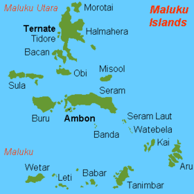
Barat Day ( indon. Barat Daya ) - a group of islands in the north-eastern part of the Lesser Sunda Islands . The location of the islands southwest of the administrative center of the province of Ambon determined their name (Barat Daya in translation from Indonesian “Southwest”).
| Barat Daya | |
|---|---|
| indone. Barat daya | |
 Barat Daya on the map of the Lesser Sunda Islands | |
| Specifications | |
| Largest island | Wind |
| total area | 10 500 km² |
| Highest point | 1412 m |
| Location | |
| Water area | Sea gang |
| A country |
|
| Provinces | Maluku |

Administratively, the islands are part of the Barat Dai district of the Indonesian province of Maluku .
Geography
They consist of one large island of Vetar (3.6 thousand km²) and small islands of Roma, Damar , Theun, Nile. The relief is mountainous, the highest point (1412 m) is located on the island of Vetar. The climate is subequatorial monsoon with distinct dry (June-October) and wet (November-May) seasons. Precipitation is about 2000 mm per year. Air temperature fluctuates around 25-27 ºС all year round. As a result of human activity, indigenous deciduous forests are replaced by secondary savannah and coconut palm plantations.