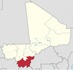
Sykaso ( fr. Sikasso ) - region (province) in Mali .
- The administrative center is the city of Sikasso ; other cities - Kutiala , Buguni .
- The area is 70 280 km² , the population is 2 625 919 people ( 2009 ).
| region | |
| Sikaso | |
|---|---|
| fr Sikasso | |
| A country | |
| Includes | 7 counties |
| Adm Centre | Sikaso |
| History and geography | |
| Square | 70,280 km² (7th place ) |
| Timezone | UTC + 0 |
| Population | |
| Population | 2 625 919 people ( 2009 ) ( 1st place ) |
| Density | 37.36 people / km² (2nd place) |
| Digital identifiers | |
| ISO 3166-2 code | ML-3 |
 | |
Geography

Sikasso market
In the north it borders with the regions of Koulikoro and Segou , in the east with Burkina Faso , in the south with Côte d'Ivoire , in the west with Guinea .
The province of Sikasso is located in the extreme south of Mali.
Population
Representatives of the peoples of Senufo , Samago , Bambara , and Pele live mainly in the province.
Administrative division
Administrative Card Sikasso.
Administratively, the province is divided into 7 districts:
| District | Square, km² | Population, [1] people (2009) |
|---|---|---|
| Bouguni | 20 028 | 459 509 |
| Kadiolo | 5,375 | 239 713 |
| Colondieba | 9,200 | 202,618 |
| Cutie | 8,740 | 575,253 |
| Sikaso | 15 375 | 725 494 |
| Yanfolida | 9,240 | 211,824 |
| Yorosso | 5 500 | 211 508 |
Notes
- ↑ Resultats Provisoires RGPH 2009 (Région de Sikasso) , République de Mali: Institut National de la Statistique , < http://instat.gov.ml/documentation/sikasso.pdf > .