Sinyavino is an urban-type settlement in the Kirov district of the Leningrad region of Russia . The administrative center and the only settlement of Sinyavinsky urban settlement.
| Settlement | |||||
| Sinyavino | |||||
|---|---|---|---|---|---|
| |||||
| A country | |||||
| Subject of the federation | Leningrad region | ||||
| Municipal District | Kirovsky district | ||||
| Urban settlement | Sinyavinsky | ||||
| Head of Settlement | Efimov Yuri Leonidovich | ||||
| History and Geography | |||||
| First mention | XVIII century | ||||
| Former names | Vagriselka, Mikhailovsky, Vagresasco, Senyavino | ||||
| PGT with | 1930 year | ||||
| Square | 91.85 [1] km² | ||||
| Timezone | UTC + 3 | ||||
| Population | |||||
| Population | ↘ 4187 [2] people ( 2019 ) | ||||
| Digital identifiers | |||||
| Telephone code | +7 81362 | ||||
| Postcode | 187322 | ||||
| OKATO Code | 41225563 | ||||
| OKTMO Code | |||||

History
The village of Sinyavino was located on the Sinyavino Heights , it has been known since the beginning of the 18th century, when by decree of Peter the Great these lands were "distributed to the settlement of Russian peasants" of the land: to Alexei Senyavin and the Navy, to lieutenant Sergei Senyavin.
As the village of Vagriselka , it is mentioned on the maps of the St. Petersburg province of J. F. Schmitt in 1770 and A. M. Wilbrecht in 1792 [3] [4] .
On the map of the St. Petersburg province of F. F. Schubert in 1834, it is referred to as the village of Vagriselka , consisting of 51 peasant households , adjacent to it is the manor Vagriselka of the landowner Dubyansky [5] .
VAGRISELKA (SINYAVINO) - the village belongs to the actual state councilor Dubyansky, the number of inhabitants under the audit: 216 m., 228 w. p. (1838) [6]
VAGRISELKA (SINYAVINO) - the village of Mr. Zinoviev, along the postal tract and country road, the number of yards - 74, the number of souls - 256. (1856) [7]
The number of inhabitants of the village according to the Xth revision of 1857: 280 m., 257 g. paragraph [8] .
VAGRISELKA (SINYAVINO) - the owner's village at the well, the number of yards - 73, the number of inhabitants: 263 m., 273 railways. P.;
Orthodox chapel. School. (1862) [9]
According to the home census of 1882, 124 families lived in the village, the number of inhabitants: 344 m., 296 g. P.; the category of peasants - the owners [8]
The peasants of the village of Sinyavino (Vagriselka) bought in 1883 from the heirs of Zinoviev, a plot of land with an area of 4213 acres and 784 fathoms, encircling Sinyavino plots [10] .
In 1867, the works of the St. Petersburg merchant V.N. Vlasov built and consecrated a wooden church on a stone foundation in the name of the Archangel Michael [11] .
SINYAVINO (MIKHAILOVSKY, VAGRESASKO) - the former owner's village of Porech volost, courtyards - 114, residents - 555;
Orthodox church, school, 3 shops, 3 inns. (1885) [12] .
According to the Materials on statistics of national economy in Shlisselburg district from 1885, 54 peasant households in the village of Senyavino (or 44% of all households) were engaged in dairy farming [13] .
According to the first census of the Russian Empire :
SINYAVINO (MIKHAILOVSKY) - village, Orthodox - 615, men - 312, women - 303, both sexes - 615. (1897) [14]
In the XIX - early XX centuries, Sinyavino administratively belonged to the 1st camp of the Shlisselburg district of St. Petersburg province.
In the early 1920s, peat mining began at Sinyavinsky swamps , at some distance from the village, and 9 peat mining villages were built.
SINYAVINO - peat mining in Maryinsky Village Council, 105 farms, 263 souls.
Of which: Russian - 98 households, 242 souls; Ingrian Finns - 1 farm, 1 soul; estov - 2 households, 9 souls; Latvians - 2 households, 6 souls; Jews - 1 household, 1 soul; Ukrainians - 1 farm, 4 souls. (1926) [15]
From 1917 to 1923, the village of Sinyavino was part of the Sinyavinsky Village Council of the Ivanovo Volost of Shlisselburg Uyezd.
Since 1923, as part of the October volost of the Leningrad district .
Since 1926, the area of the city of Shlisselburg.
Since February 1927, as part of the Mginsky volost, since August 1927, as part of the Mginsky district [16] .
On April 20, 1930, the settlements of peat developers were administratively united into the working village of Sinyavino [17] .
According to 1933, the village of Sinyavino was the administrative center of the Sinyavinsky village council of the Mginsky district, which included 2 settlements: the village of Gontovaya Lipka and the village of Sinyavino , with a total population of 1,714 people [18] .
According to 1936, the Sinyavinsky Village Council with an administrative center in the working village of Sinyavino included 4 settlements, 108 households and 1 collective farm [19] .
During World War II , fierce battles took place in this area; both the village and the village were completely destroyed. During the battles on the Nevsky Piglet and Sinyavinsky Heights , more than 360,000 people died.
After the war, the village of Sinyavino was not restored, the village was restored in more modest territorial borders.
Since 1944, as part of the Sinyavinsky Council.
Since 1960, as part of the Tosno district .
Since 1963, the Sinyavinsky City Council is subordinate to the Tosno City Council.
Since 1965, Sinyavinsky City Council is subordinate to the Kirov City Council [16] .
According to the data of 1966 and 1973, the working village of Sinyavino was also subordinate to the Kirov City Council of the Tosnensky District [20] [21] .
According to 1990, the village of Sinyavino was under the administrative subordination of the Kirov region [22] .
Geography
The village is located in the northwestern part of the district on the P21 ( E 105 ) highway ( St. Petersburg - Petrozavodsk - Murmansk ) Kola .
The distance to the district center is 8 km [22] .
The distance to the nearest Petrokrepost railway station is 9 km [22] .
Demographics
Change in population over the period from 1838 to 2018 [23] [24] [25] [26] [27] [28] [29] [30] [31] [2] [32] :
Economics
The main enterprises of the village:
- meat processing plant
- poultry farm "North" .
Coat of Arms
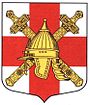
The coat of arms of the Sinyavinsky city settlement was approved by the decision of the Council of Deputies of the MO of September 15, 2008 No. 24. The coat of arms was developed by a creative team led by K. S. Bashkirov . The coat of arms is entered in the State Heraldry Register of the Russian Federation No. 4372 .
Coat of arms description:
In a silver field there is an inscribed red (red) cross; on top of the cross - two golden swords decorated with black sheath, crosswise, arms up; on top of it is a golden Russian helmet [33] .
Monuments and Landmarks
- Obelisk at the burial place of soldiers who died in World War II
- In the vicinity of the village there is a monument at the meeting place of soldiers of two fronts and a monument in honor of the participants in the assault on Sinyavinsky heights , obelisks on the mass graves of Soviet soldiers who died in battle.
- Bronze bust on the central square in memory of twice Hero of the Soviet Union Kravchenko Grigory Panteleevich .
- A commemorative plaque on the house number 13 on the street Kravchenko in memory of twice Hero of the Soviet Union Kravchenko Grigory Panteleevich.
Gallery
|
|
|
Famous residents
- Morozov, Yuri Andreevich - Soviet football player, Russian football coach, Honored coach of the USSR.
- Kravchenko Grigory Panteleevich - lieutenant general of aviation, pilot ace, the first twice Hero of the Soviet Union . He died in battle at Sinyavino February 23, 1943.
Streets
Eastern, General Margelov, Country, Green, Oblique, Kravchenko, Red Dawn, Forest, Forest Lane, Meadow, Murmansk highway, New, Sand, Victory, Reutov, Sadovaya, Sadovy lane, North, Labor, School, South [34] .
Gardening
Lipki, Priozernoe, Sinyavinsky, Nightingale [35] .
Notes
- ↑ Settlements. Administrative division of the Leningrad region. - SPb., 2007, p. 38 Archived on October 17, 2013.
- ↑ 1 2 Resident population by context of municipalities of the Leningrad Region as of January 1, 2019 . Date of appeal April 27, 2019.
- ↑ "Map of the St. Petersburg province containing Ingermanland, part of the Novgorod and Vyborg province", 1770
- ↑ “Map of the circle of St. Petersburg” by A. M. Wilbrecht. 1792
- ↑ Topographic map of St. Petersburg province. 5th layout. Schubert. 1834
- ↑ Description of the St. Petersburg province by counties and camps, 1838
- ↑ Alphabetical list of villages by counties and camps of the St. Petersburg province. 1856
- ↑ 1 2 Materials on the statistics of the national economy of the St. Petersburg province. Vol. 2, Peasant farming in Shlisselburgsky district. // Numerical data on the peasant economy of St. Petersburg, 1885, p. 310, p. 32
- ↑ "Lists of the populated areas of the Russian Empire, compiled and published by the Central Statistical Committee of the Ministry of the Interior" XXXVII St. Petersburg Province. As of 1862. SPb. ed. 1864 p. 191
- ↑ Materials on the statistics of the national economy of the St. Petersburg province. Vol. 2, Peasant farming in Shlisselburgsky district. // Notes to the tables. St. Petersburg, 1885, p. 310, p. 133
- ↑ Historical and statistical information about the St. Petersburg diocese for 1884., P. 274
- ↑ “Volosts and the most important villages of European Russia. Issue VII. Provinces of the lakeside group ”, St. Petersburg. 1885, p. 92
- ↑ Materials on the statistics of the national economy of the St. Petersburg province. Vol. 2, Peasant farming in Shlisselburg district, St. Petersburg, 1885, p. 310, p. 185
- ↑ “Populated places of the Russian Empire according to the first general census of 1897”, St. Petersburg, 1905, p. 197
- ↑ List of settlements of the Pargolovskaya volost of the Leningrad district according to the 1926 census. Source: PFA RAS, f. 135, op. 3, d. 91.
- ↑ 1 2 Handbook of the history of the administrative-territorial division of the Leningrad Region.
- ↑ Reference book of the history of the administrative-territorial division of the Leningrad Region. Mginsky district.
- ↑ Administrative territorial division of the Leningrad region. - L., 1933, p. 52, 283
- ↑ Administrative and economic guide to the Leningrad region. - L., 1936, p. 165
- ↑ Administrative and territorial division of the Leningrad region / Comp. T.A. Badina. - Reference book. - L .: Lenizdat , 1966 .-- S. 36 .-- 197 p. - 8000 copies. Archived October 17, 2013. Archived October 17, 2013 on Wayback Machine
- ↑ Administrative territorial division of the Leningrad region. - Lenizdat, 1973, p. 39 Archived on March 30, 2016.
- ↑ 1 2 3 Administrative and territorial division of the Leningrad Region. - Lenizdat, 1990, ISBN 5-289-00612-5 , p. 77
- ↑ Administrative territorial division of the Leningrad region. - L., 1933, p. 93
- ↑ Administrative and economic guide to the Leningrad region. - L., 1936, p. 21
- ↑ 1959 Census of the USSR Archived July 19, 2011.
- ↑ Census of the USSR 1970 1970 Archived on January 6, 2012.
- ↑ 1979 Census of the USSR; Archived September 12, 2011.
- ↑ All-Union Population Census 1989. The number of urban population of the RSFSR, its territorial units, urban settlements and urban areas by gender
- ↑ Administrative territorial division of the Leningrad region. - SPb., 1997, p. 21
- ↑ Population of Russia, federal districts, constituent entities of the Russian Federation, districts, urban settlements, rural settlements - district centers and rural settlements with a population of 3 thousand or more people
- ↑ Results of the 2010 All-Russian Population Census. Leningrad region.
- ↑ Population of the Leningrad Region by municipal entities as of January 1, 2018
- ↑ Materials of the Administration of the Sinyavinsky urban settlement and the newspaper Nasha Gazeta (Bulletin of the Sinyavinsky municipal settlement), issue 12 (24), December 2008
- ↑ System "Tax Reference". Directory of postal codes. Kirovsky district, Leningrad region. Sinyavino. Streets.
- ↑ System "Tax Reference". Directory of postal codes. Kirovsky district, Leningrad region. Sinyavino. Gardening.
Bibliography
- Sinyavino. Autumn battles of 1941-1942. A collection of memoirs of participants in the Sinyavino battles. I.A. Ivanova (ed.). SPb., Polytechnic, 2008.
Links
- Sinyavino (Leningrad Region) - article from the Great Soviet Encyclopedia .
- Official site of Sinyavinsky urban settlement