Agger ( German: Agger ) is a river in Germany that flows along the land of North Rhine-Westphalia , its river index is 2728. [1] The river basin area is 816.244 km², [1] and its total length is 69.5 km [1] .
| Agger | |
|---|---|
| him. Agger | |
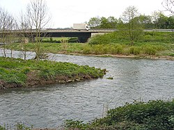 Sylt's confluence (bottom) to Agger (top) Sylt's confluence (bottom) to Agger (top) | |
| Characteristic | |
| Length | 69.5 km |
| Swimming pool | 816,244 km² |
| Watercourse | |
| Source | |
| • Height | 437 m |
| • Coordinates | |
| Mouth | Zig |
| • Height | 52 m |
| • Coordinates | |
| Location | |
| Water system | Sieg → Rhine → North Sea |
| A country |
|
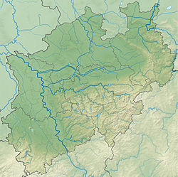
| Region | North Rhine-Westphalia |
Content
- 1 Geography
- 1.1 Current
- 1.2 Inflows
- 2 History
- 3 notes
Geography
Current
The source of the river is located on the southern outskirts of Meinerzhagen at an altitude of about 437 meters above sea level, a kilometer west of the source of Volme . First, Agger flows south, absorbing several small watercourses on the right and left, then is blocked by the dam . Here Renge from the east and Genkel from the north join him. After the dam, the river turns west, rounding the mountain of Helenberg in an arc.
It flows into the Sieg on the right side between the cities of Troisdorf and Siegburg , located west and east of the Agger mouth, respectively, at an altitude of about 52 meters above sea level.
Agger flows through the Merkish , Oberbergish , Reinisch-Bergisch and Rhine-Sieg districts along its route.
Tributaries
| Title ( Russian ) | Title ( German ) | A place confluence [km] | Left/ right inflow | Length [km] [1] | Area basin [km²] [1] | Height [m asl] [2] | Index |
|---|---|---|---|---|---|---|---|
| Rengse | 61,463 | left | 5,630 | 7.475 | 284 | 2728 12 | |
| Genkel | 60,890 | on right | 7,102 | 10,656 | 284 | 2728 14 | |
| Dörspe | 56,035 | left | 11,747 | 27,633 | 202 | 2728 18 | |
| Steinagger | Steinagger | 55,830 | left | 11,424 | 30,343 | 201 | 2728 2 |
| Seßmarbach | 51,481 | on right | 9,036 | 20,182 | 181 | 2728 32 | |
| Rospebach | 48,779 | on right | 8,194 | 13,279 | 169 | 2728 34 | |
| Strombach | 48,548 | on right | 8,313 | 6,390 | 169 | 2728 36 | |
| Loper bach | 43,766 | on right | 3,068 | 10,017 | 153 | 2728 38 | |
| Ville | Wiehl | 41,779 | left | 33,594 | 140,721 | 145 | 2728 4 |
| Walbach | 38,284 | on right | 5,057 | 6,581 | 132 | 2728 52 | |
| Kaltenbach | 36,227 | left | 5,356 | 5,756 | 126 | 2728 54 | |
| Leppe | Leppe | 33,811 | on right | 19,392 | 52,227 | 119 | 2728 6 |
| Loopebach | 30,589 | left | 7,697 | 12,528 | 111 | 2728 72 | |
| Schlingenbach | 25,884 | left | 6,613 | 8,731 | 99 | 2728 74 | |
| Nafbach | Naafbach | 9,963 | left | 22,652 | 45,869 | 67 | 2728 78 |
| Sulz | Sülz | 7,102 | on right | 48,711 | 244,571 | 62 | 2728 8 |
| Jabach | 6,901 | left | 7,809 | 7,523 | 61 | 2728 92 | |
| Auelsbach | 5,412 | left | 7,417 | 7,720 | 59 | 2728 94 | |
| Rothenbach | 2,806 | left | 5,672 | 56 | 2728 994 |
History
On 2 January 1584, in the lower reaches of the river, the , one of the battles of the Cologne War, took place .
Notes
- ↑ 1 2 3 4 5 Gewässerverzeichnis des Landesamtes für Natur, Umwelt und Verbraucherschutz NRW 2010 (XLS; 4.67 MB) ( details (German) )
- ↑ Messung anhand Deutscher Grundkarte 1: 5000