Sebelan [2] or Kuhe-Sebelan [3] (outdated Savalan [4] ; Pers. سبلان , pronounced: Sabalan) is an extinct stratovolcano in the east of the Armenian Highlands [5] [6] , in the north-west of the Islamic Republic of Iran , in the Ardabil ostan . Height 4811 [6] or 4821 meters [3] .
| Sebelan | |
|---|---|
| Persian. سبلان | |
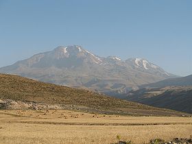 Volcano in July 2006 | |
| Specifications | |
| Volcano shape | Stratovolcano |
| Education period | Holocene |
| Last eruption | is unknown |
| Highest point | |
| Absolute height | 4811 [1] m |
| Relative height | 3283 m |
| Location | |
| A country |
|
| Ostan | Ardabil |
| Mountain system | Armenian highlands |
| Ridge or array | Elburs |

The Sebelan Upland is connected in the west with the chains of Karadag and through them with the mountains of Armenia and Transcaucasia .
Sebelan in the south is separated by the Adzhichai river valley from the western spur of the Talysh mountains , in the east by the Karasu river valley from the main chain of Talysh. The volcanic origin of Sebelan is indicated by the composition of the rocks composing it, and the shape of the peak (a truncated cone, partially failed), and the presence of hot sulfur springs on its slopes. The top of Sebelan is almost always covered in snow.
According to Kazvini , on this mountain the prophet Zarathushtra spoke with Ahura Mazda [7] .
Content
Geography
The main peak of Sebelan has a height of 4811 m and is called "Soltane-Savalan" (Sultan of Savalan). There are two more less high peaks: Käsre-Dah and Haram-Dah (4400 m high). Sebelan is located in a geographical triangle between three large cities: Ardabil in the east, Meshchginshchr in the northwest and Serab in the southwest. [eight]
In Armenian sources it is also mentioned in the form of Sahvarzan [9] .
Hydrography
Due to its very high altitude and exposure to humid air from the Caspian Sea in the east, Sebelan has an important feature - it is characterized by a constant high degree of humidity, as well as the constant presence of a snow cap on it, because of which a huge amount is sometimes accumulated in the crater water, resulting in the formation of the only crater lake in Iran, 145x80 m, 40 m deep. This lake is unique in terms of limnology. It is located 25 m below the peak of the volcano. Due to the very low temperatures, the water in the lake is frozen (with the exception of the summer months). The waters of the lake are sulfate in terms of chemistry, and are very rich in silicon [10] . In addition to Lake Sebelan, other mountain lakes at a lower altitude are Atgoli, Ardabil Kara-Gol, Sarap Kara-Gol, Kyzyl-Bare-Gol, Kuri-Gol and Sary-Gol. Directly near the top are seven small glaciers. The long-term presence of snow and the relatively high average annual rainfall (more than 500 mm) lead to the formation of numerous streams and small rivers in this stratovolcano, which can be divided into two closed catchment basins: Urmian and Caspian. The Caspian basin covers all southeastern water bodies that flow into the river Balag-Chai, as well as the north-western (Ahar-Chai) and eastern, as well as the north-eastern, which, together with the above, come into contact with the Karasu river, then with Araks and finally with Kura. The Urmian basin is limited to the water bodies of the southwestern slopes that flow into Talh-e Ruda.
Geology
Together with Sekhend and Ararat in neighboring Turkey, Sebelan is a tectonically active volcanic region in which strong earthquakes are quite frequent. But, as for the peak itself, tourists and locals have nothing to fear: the eruption of the Sebelan volcano has not been observed for many thousands of years. Its internal activities are manifested in the form of various thermal sources, where sulfates are primarily observed. Their temperature is from 21 to 82 ° C [11] .
Vegetation
The size and topography of Sebelan play an important role in ecology and have a serious impact on the climate and vegetation of northwestern Iran, namely the Ardabil region, as well as Western and Eastern Azerbaijan. On more gentle slopes up to 2500 m above sea level, automorphic soils are favorable for agriculture, the steppe type of vegetation predominates. Above this height, agricultural conditions are very unfavorable, so there are no permanent settlements there. The second vegetation cover zone covers regions up to 4000 m, where the alpine type of meadows predominates, and there is no vegetation above 4000 m [12] .
Economics
Historically, Sebelan has been of great economic importance in a regional and local sense. In the regional plan, the volcano and the surrounding area contains a large number of mineral and thermal springs ( Persian : ab-e garm, lit. “hot water”), which attract both the local population and tourists, since sulfur thermal springs are very powerful in treatment of skin diseases [13] . Iranist G. Schweizer points out that in these sources in the 1960s. treated not only people, but also animals of local peasants. On the southern slopes of Sebelan, thermal spas have been built with modern medical centers, which are regularly visited by tourists from Tabriz and Tehran. From a local point of view, Sebelan, due to favorable climatic conditions, is a region very suitable for agriculture, especially on the gentle southern slopes. There has historically been a big contrast between Sebelan and Sehend in a way of life - in the mountains of Sebelan, a nomadic way of life dominated, and in Sahanda - permanent agricultural settlements. The nomads were mainly Kurds, who lived north of Sabalan up to the Mogan steppes and the Araks river, and their six main tribes were Chalabyan, Muhammed-Khanlu, Huseynaklu, Haji Alilu, Hassan Begl and Karachol. The upper summer pasture border was 3800 m, and nomad Kurds set up tents up to 3500 m. These ousted Shiite groups switched to a settled lifestyle during the 20th century [14] [15] . The complete transformation of the surroundings occurred as a result of the construction of the dam and other irrigation systems, due to which the pastures were turned into fertile agricultural territories. In addition to health tourism, sports and ecological tourism are also developed in Sebelan. Tourists are attracted by the very beautiful summer nature of the volcano and the surrounding area. Popular sports include mountain climbing and skiing - the modern Alvars ski center has been built in Sebelan [16] .
Links
Notes
- ↑ Sebelan : [ eng. ] // Global Volcanism Program . - Smithsonian Institution .
- ↑ Map of Iran, scale 1: 2 500 000, GUGK, 1986.
- ↑ 1 2 Topographic maps of the General Staff unopened (inaccessible link) . Date of treatment November 12, 2014. Archived March 22, 2015.
- ↑ Savalan // Brockhaus and Efron Encyclopedic Dictionary : in 86 volumes (82 volumes and 4 additional). - SPb. , 1890-1907.
- ↑ Sebelan - an article from the Great Soviet Encyclopedia .
- ↑ 1 2 Geography. Modern illustrated encyclopedia. Article: Armenian Highlands . - M .: Rosman. Edited by prof. A.P. Gorkin. 2006.Original text (Russian)The most significant in height. extinct volcanoes Big Ararat (5122 m), Aragats (4090 m), Sebelan (4811 m), Syuphan (4053 m), Small Ararat (3896 m).
- ↑ James R. Russell. Zoroastrianism in Armenia. - Harvard University, 1987 .-- P. 164.
- ↑ سبلان بلند ؛ سهند زيبا unopened (inaccessible link) . Date of treatment June 6, 2019. Archived on April 20, 2018.
- ↑ Robert H. Hewsen. The Geography of Ananias of Širak: Ašxarhacʻoycʻ, the Long and the Short Recensions. - Reichert, 1992 .-- P. 259.
- ↑ http://sat.co.ir/aboutsabalan.html
- ↑ Harrison, John Vernon (1968.). "2. Geology", in: Fisher, William Bayne: The Land of Iran, The Cambridge History of Iran I. Cambridge, UK: Cambridge University Press, p. 132, DOI: 10.1017 / CHOL9780521069359.003, ISBN 9780521069359 , OCLC 489573396.
- ↑ Ehlers, Eckart (14.1.2011.). Sabalan Mountain, Encyclopædia Iranica. New York: Columbia University
- ↑ Bromley, Christopher; Khosrawi, Khosrow; Talebi, Behnam (2000.). "Geophysical Exploration of Sabalan Geothermal Prospects in Iran", in: Iglesias, Eduardo: Proceedings of the World Geothermal Congress, 2000. Tokyo: International Geothermal Association, p. 1009.-1014, ISBN 9780473068110 , OCLC 123421560.
- ↑ Schweizer, Günther (1974.). The Aras-Moghan development project in Northwestern Iran and problems of nomad settlement, Applied Sciences and Development IV. Wiesbaden: Franz Steiner Verlag, p. 134.-148, OCLC 604404664.
- ↑ Tapper, Richard (2002.). in: Thompson, Jon: The Nomadic Peoples of Iran. London: Azimuth Editions, p. 260.-283, ISBN 9781898592242 , OCLC 59463669.
- ↑ آشنایی با کوه سبلان - اردبیل - همشهری آنلاین